11TH DECEMBER 2023 Hill of Foudland
Photos
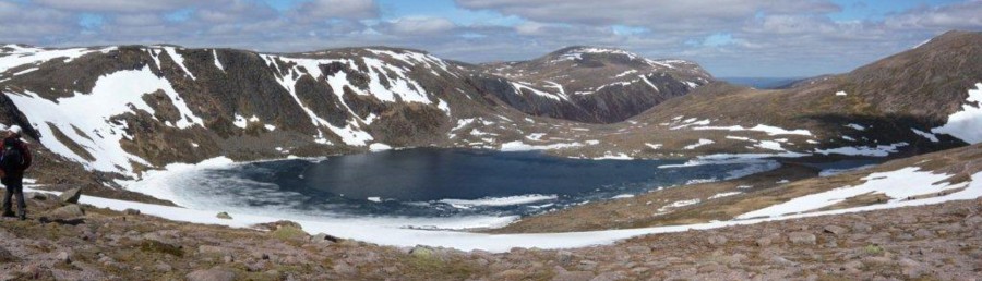
The Hill of Fou(n)dland (both spellings permitted) , recognisable to all who lift their eyes when travelling along the A96 Inverness Road, has been quarried for its midnight blue slate over some centuries. Sadly, foreign slate is more commercially viable, and so only small derelict spoil heaps adorn its slopes; and modern communication masts adorn its summit - yet it is still a notable hill, as it sternly forces the A96 around its perimeter.
And for a short half day walk suitable to the low light of December, it is an easy stroll, on easy track, with a trig to visit, and those new-fangled tree plantations to admire (and to ponder the cost to the tax payer for their subsidies…) - we're so impressed by the alternating rows of exotic spruce with native pine.
On another day, with better visibility, you would admire the views south over the strath of the Gadie burn to Bennachie, or look north to the much improved weather at the Moray Firth; or today just to welcome the expensive new pedestrian gate into the old sheltered conifer plantation, along the narrow crooked path among the trees down past the wreckage of Storm Whoever, back to the cars.
Our great finish, though, is really the excellent food at Morgan McVeigh's, well worth a visit, the Xmas turkey an absolute treat (other options available, and just as good!).
And yet again I thank the drivers (this time Geoff, Nick, Andy, June & Bill), but also, at the end of 2023, I want to thank all the walkers who come on these walks. As our Secretary and main Organiser, James B, always says - without walkers, there would be no walks. So thank you everyone who turns out for these Monday walks - I hope you enjoy them as much as I do. And if you have any requests for 2024 walks, email me now - the next year's programme is in production and will be with you before the New Year!
3RD DECEMBER 2023 Pitfichie Forest and Tillyfourie Quarry
Poster
Photos
Main Walk
To round off the 2023 CHC Sunday Walks programme, the chosen walk was around Pitfichie Forest followed by Xmas Lunch at the Bennachie Lodge in Kemnay. The weather over the past few days had been very cold, clear, wind free and dry. Luckily for us, although not quite so bright, this continued into Sunday. My garden thermometer in Alford dipped to -9c early Sunday morning, but for us at our arrival at Pitfichie Forest car park, the car ambient thermometer read -5c at 8.30am. Eighteen walkers once booted up, some coming wisely prepared with micro-spikes on for the slippery conditions, set off up the main track to head for Tillyfourie Quarry. The chosen route led us down the edge of the woods on a track of sorts to join a more distinct path that led us to a small scale quarry that was close to a siding for the old Alford Valley Railway. This railway which opened in 1859 connected with the Great North of Scotland Railway mainline at Kintore. The last passenger train that ran on this line was on 31 December 1949. The final goods train was exactly 16 years later on 31 December 1965. From here we went north on a defined track that used to be a narrow gauge incline, worked by gravity to transport the granite rock from the main quarry down to the smaller workings and on to the rail line for transportation. The main quarry that opened in the late 19th century soon came into view. The tall brick chimney that is still standing on a granite plinth with a platform, was probably used for a boiler. The steam produced from here was used to operate three cranes for quarrying use. The exit route from here was round some wind blown tree terrain before joining the main track. Following this westward and branching off at the next junction, we soon ascended a path that led us to the 361m spot height of White Lady Hill. Lovely views were had from here, especially with a dusting of snow and hard front on the hills making the effort of the day all the more worthwhile. After a short refreshment break at the low point between here and Green Hill we ascended this hill to reach our high point of the day, 399m. Despite the BBC weather app forecasting 0% chance of precipitation for our chosen walking area, we could see quite a few localised showers to the east and south. The weather gods were on our side for our last Sunday walk of 2023 and it stayed dry for the descent off the hill and the walk back on the main track to the carpark. From here it was a short drive to the hotel in Kemnay to meet up with 7 members of the Saunter group and a most enjoyable social Xmas lunch was had. Thanks to all who came along, our backmarker for the day and of course a special thanks to all the volunteer drivers, not just today, but throughout the whole year. Without your assistance and driving skills in sometimes tricky conditions these walks would not be possible. Merry Xmas, a healthy, happy and prosperous New Year to you all
Sunday Saunter
We arrived in the car park on a cold and frosty morning at an hour rather later than our usual start; some might say, "the best of the day was already past" but early starts are not in the nature of Saunterers even it means grabbing the last space in a busy car park. The long walkers were off much earlier to explore the highs of Tillyfourie and the lows by way of visiting the long deserted and water filled quarry and Turriff Hillwalking and Mountaineering Club were reported to be in the vicinity.
Also floating by but at a distance was a hot air balloonist appearing stationary in the still air sharing the space with the large and numerous skeins of geese honking on their way to look for some grass free of frost to feed on. Back on the ground the Saunterers turned to face the forest and make their way out of the car park and up an increasing frosty track where the white prospect seemed largely to be the result of prolonged frost rather than snowfall, the pine needles and heather festooned with delicate crystals.
Forest tracks usually lead into the trees and this one was no exception with unexceptional views of the trees; a large area clear felled brightened the way and in due course the path giving access to the upper slopes of the hill appeared and we carefully picked our way over the less slippery footholds as the path steepened and wound round boulders and tree roots. Steepness here was good as we all warmed up and the south facing slope meant much of the hard packed frost, now with a little snow in the mix had melted and also the view to the west where the sun was shining became apparent. Lochnagar looked well covered and in the far distance the Cairngorms glowed as if lit from within.
Our path, deep set into the hillside thanks mostly to the passage of innumerable mountain bikes took us close to the summit of our wee hill now covered with an inch or two of lovely fresh snow. For Saunterers close is usually close enough but the best view hereabouts is definitely from the highest point looking over the Howe of Alford and beyond so if you get some snow in your boots making your way across to enjoy it, you should have put on your gaiters!
The descent was much less steep and we were soon on easier ground after passing a few birds busy amongst the trees prying pine cones apart for the seeds; were these crossbills? They were just too far to be sure without binoculars. Tall larches flanked our way down to the main track were the view to the south and east caught the eye. The Hill of Fare awaiting its proposed 21st century development and the Barmekin at Echt comfortably clothed with the remains of its prehistoric fort. Also prehistoric beside our track is Whitecairns stone circle dated to 2000BC but looks as old as the huge stones that make it.
An easy walk back to the car park completed the walk, a walk that started with birds and for some, finished with another.
20TH NOVEMBER 2023 Gartly Moor and Knockandy Hill
Photos
Always irritating when you carefully keep an eye on the forecast, decide the day before that everything’ll be fine for your walk, then wake up to find the Met Office has changed its mind… However, there’s really- bad and not-so-bad, so off we went to Gartly Moor (not on Google Maps!), to begin the day with romantic mist draping the landscape as we climbed the road and track on to the Moor. This name is mainly misleading, as it is largely planted with non-native conifers, but easy track (used for rallying – Bill told us how fast he’s taken these tracks, unbelievable but I won’t repeat it here…) took us to a beautiful mast vanishing into the mist (I’m becoming a connoisseur, see last walk), and then on to where the Forestry were working hard removing huge piles of timber, but no signs telling us to go away, very good.
Soon after the country changed: we broke thru to the Knockandy slopes and watched the sheep cantering off, not being used to humans in these parts. The trig was in a beautiful location but sadly as well as the mist, we now had rain and gusty wind to contend with. A quick exit downhill for lunch under the pines, and an onward route sheltered by the forest trees, followed by the slightly unnerving sight of cows running towards us… they soon realised we had no hay, and we continued down the most amazing steep cow-created mud zigzags to the burn and the road bridge. Here, the vision of the rain blowing across the field made us decide the road was the better part of valour, so after climbing the gate, we enjoyed the relative calm of the leg stretch back to the cars.
Finally a great coffee & cake stop at Kellockbank garden centre - I’m not allowed to say the best part of the day!
5TH NOVEMBER 2023 Tors of Ben Rinnes
Poster
Photos
Main Walk
With numerous Amber and Red wind and rain warnings, and the accurately predicted record rainfall amounts (three times the October average in Inchmarlo), the Club were back out on the hills again on November 5th. The walk chosen was the rain postponed October trip up Ben Rinnes, by a route not taked before, a direct assault
From the distillery at Milltown of Edinvillie, simply known as Benrinnes distillery. Originating in 1926 it currently produces whisky primarily for blending, doesn't have a visitors centre, and although currently producing appeared to be not so when we parked our cars and donned our boots.
An old, rarely used, track took us uphill passing at short distance from the informal distillery "pond" to the edge of a planted woodland and a gate to the open moors. The track continued a steady upwards with the top of Ben Rinnes showing in silhouette against the bright (and very welcome) sun. With some altitude gained, views opened up to the northeast towards Abelour, and though broken cloud still hung is some of the valleys and hollows under an overnight inversion, skies above (and a forecast of a dry da) looked very promising.
Our chosen route deviated off the track onto a clear path through the heather on what was a fairly wet slope of the hill. A brief steep section brought us onto the first granite tors of Ben Rinnes, known locally as "Scurran of Well", scurran being a Gaalic word for peak or pinnacle used particularly on Ben Rinnes. A brief stop to admire the expanding views before turning south to the next scurran known as the Ladies Chair. What feature warranted this name was not obvious but the scurrans were impressive, granite, but heavily grooved horizontally where weaker rocks had been weathering out of the eons, with the many of the sides of the scurrans just rising almost vertically out of the heath. These vertical walls made a perfect backrest for a sit down and our first bite to eat (perhaps that's how they gained the name "Chair") with the sun shining down on us, not a breath of wind, and no midges (too cold or all drowned in the recent rains).
After some walkers scrambled up the wet, surprisingly slippery granite to the highest scurran it was a south heading to reach the summit of Ben Rinnes 840m with a trip point and now the best views to the northeast down the Spey Valley and far away (25km) the Moray coast. From the summit a short walk gently downhill took us to the Scurran of Morinsh. So convivial were conditions another refreshment stop was made this time with a view upstream the Spey, where the glen was partially obscured by persistent inversion clouds. Amazingly as we basked, two very separate snow patches were espied on southwest facing slopes at 750m altitude directly facing the afternoon sunshine. Close inspection of one of these clearly indicated three different layers.
Now turning our back on the weakening sun our return took us across rougher moorland to arrive at Fauldgates Cairn, the reason for it not being known. The onward path took us over Bay;s Hill (pronounced Babbies), reputed to be the second resting place of a local witch, the first being too close to town!!.
We rejoined out outward track downhill that gave us good views of the quiescent distillery and its rather impressive smooth red chimney stack, which on closer inspection proved to be red brick, overpainted red.
An inspiring November day in the hills, 11.5 km in a leisurely five hours. Thanks to Bill for organising the event (twice, October and November), and thanks to all the drivers for covering a quite a high mileage.
Sunday Saunter: Tullich
Tullich in the title and Tullich on the ground but not many travellers who pass by or who stop at the cheese factory or leave their vehicle at the Forestry and Land Scotland car park (signposted Cambus o' May) are aware that it was the centre of the community, the first burgh on Deeside until the development of Ballater in the 19th century. As early as 1798 the church was abandoned with the creation of the parish Glen Muick, Glengairn and Tullich with the new parish church in Ballater. A new bridge over the Dee and a spa at Pannanich moved the focus of the area to Ballater and with the coming of the railway most of Tullich's people moved to the ever growing village.
The car parking area outwith the FLS close to the road that's free to use had plenty of space and so it was as our cars rolled in close to the 11:00 start time and a brisk walk took us into the woods, a mature plantation of pine trees dark in the late autumn sunlight. As the pine trees are left behind the footpath to take us into the native birch woods starts somewhere in the area but it's not easily found as it's overgrown with gorse, juniper and very healthy heather but once that's out of the way the route is clear leading us up into a landscape of autumn colour in the now bright sunshine. The birch have retained plenty of golden leaves, the larch's yellow needles mostly carpeting the grassy surrounds and here and there fly agaric mushrooms stud the heath their red caps giving a warning to keep away but one that is clearly ignored as their tops have been nibbled by some hungry unknown creature.
Quite soon we become aware of the quarry spoil heaps, man-made screes of discarded rocks, a something that might appear to be a disfigurement in the rural countryside but 90 years or so after the abandonment of the quarries nature has reclaimed these piles and ridges and they now seem to be a natural feature. Scots pine now soften and, in some parts, obscure the old workings where the red, close grained granite cliffs have been blasted apart to produce the building stone much in demand as the area developed. The passer by now sees, if they push their way into the old quarries, blocks looking as fresh from the cliff now as when they were liberated but it is the scale and smoothness of the worked cliffs that is so surprising. These high walls of rock are smooth, the surface mostly unblemished and the visible features fine cracks and flakes. Where faults have left blocks, some looking precariously balanced and ridges they are massive, some leaving overhanging roofs and deep cracks.
The flat working area outside the quarries is a wide ledge that overlooks the flat land of the Dee valley that gives outstanding views east downriver to the white towers of the suspension bridge and west to the domineering massive of Lochnagar with its aspiring acolyte the Coyles of Muick in the foreground. Here we sit taking our coffee and later lunch in the sunshine enjoying the unbelievable balmy warmth of a November afternoon blessing our good fortune to be out and about in such stunning scenery. As we ate a passing butterfly, a red admiral found one of our number irresistible spending some time resting on her hair.
We might have sat there and enjoyed the sunset, maybe next time, but we had to move on to the next attraction of this most interesting of Saunters. The western quarried cliff has the highest and possibly the smoothest walls and is well used by rock climbers, now perhaps better described as rock athletes and technologists such are the moves they make and the equipment they need to progress. Here the walls have been bolted to provide protection and engaged in some precarious, but carefully judged manoeuvres was a climber tightly attached to his safety rope while others waited their turn. Not something you see everyday but as none of the Saunterers showed any interest in following the youngsters up the cliff we moved on downhill away from the quarries and back on a track that led west to the Culsten Burn. This, to borrow rock climbing jargon was the crux of our walk.
As we approached the burn the sound of running water increased to rushing water, that gurgling, splashing sound of a good going burn in spate and looking across the flat area where the water was more placid it was still too deep to ford safely, never mind dry shod. Earlier, I had described this as a possibility and I sensed some disappointment then if we had to turn back, so we didn't. The only way was upstream and after fifty yards the stream narrowed and a small tree was conveniently growing out of the bank to provide a hand hold and a suitably mossy foothold to launch the Saunterers over the foaming maelstrom. Once launched everybody landed as dry as they started, some needing a helping hand none the worse for their little adventure.
Away from the burn the way was a tranquil wander through the trees now a mixture of aspen, oak with the occasional cherry tree to brighten the prospect; here a lochan hosted a few mallard and on the far side the biggest bird box I've seen, possibly Airbnb for owls. The lovely rolling countryside gave way to a strip of farmland then down to the A93 and Tullich Kirk with its impressive collection of carved stones all luxuriously displayed in a concrete and reinforced glass case. Following the circular cemetery wall, so built to deny the Devil a hiding place we joined the Deeside Way and a kilometre took us to the base of the cnoc supporting the Monaltrie Monument. The way up is a delightful walk through more birch trees to the obelisk standing on top of this sandy hill. It commemorates William Farquharson of Monaltrie (1753 - 1828) who did a lot of work improving the area. The inscription faces west towards Ballater and Lochnagar and by the looks of the path up it's rarely visited now. We followed the lie of the land back to the Deeside Way and just as we reached the end of the Saunter the tea room at the cheese factory claimed our attention still warm and sunny enough to sit outside.
30TH OCTOBER 2023 Geallaig Hill & Mammie
Photos
After two weeks of endless rain, floods and wind, we were incredibly lucky to be gifted the first day of dry, a day with views, a day with some wind, fair enough, but only enough to make you feel you were on a mountain…
Once the party of nine had convened – after exciting delays caused by a bus on fire en route - the decision was taken to tackle the steep climb up Geallaig immediately, thereby putting off the low farm land and its likelihood of wet to near the end of the walk. We watched as a dozen vehicles swept past us, carrying pheasant shooters, gamekeepers and dogs, to their first drive of the day, luckily across towards Rineten and away from our route.
An hour took us to the summit; after the coffee stop, the stroll down the track, getting warmer and more sheltered, was very enjoyable, with interest provided by the amazing stretches of young pines (planted? regen?), red deer prints and mysterious poo declared to be raptor by our Poo Expert Andy.
Lunch by the pheasant rearing area, then over the Gairn footbridge and up a bonus hill, the wonderfully named Mammie, complete with an irresistible mast, which new views to Morven, Mona Gowan, Scraulac, Carn a Bhacain, and up to Ben Avon and Beinn a Bhuird. And of Glen Gairn looking its best with its birches and larches clad in gold.
Descending, and duly dealing with the wet and muddy ground predicted earlier, we met with the pheasant shooters, fortunately finished for the day, then finished our route with a trip along past the new Gairnshiel bridge (not a thing of beauty nor a joy forever), over the old bridge and back uphill to the start.
My thanks to all who came - thank you for the great company, and of course especial thanks to drivers Sue, June and Andy.
28TH SEPTEMBER-1ST OCTOBER 2023 Strathpeffer Weekend
Photos
Twelve club members spent the long weekend at the Ben Wyvis Hotel in Strathpeffer. This was an excellent location with many hills within driving distance and shorter local walks from the village itself, which also has some excellent tea shops. Some visited the Highland Museum of Childhood on the former Strathpeffer railway station and the Pictish Eagle Stone on the outskirts of the village. This was the Club’s first weekend at Strathpeffer.
The weather forecast on Friday was for high winds so many of the group opted for lower level local walks, while a group of four went up the Corbett Little Wyvis and one brave member battled his way up and down the Munro Ben Wyvis (which he nicknamed Ben No-vis!). On Saturday the weather improved. One group headed off to the Strathfarrar Munros where they were joined by two club members who were staying elsewhere in Campervans, one climbed Maoile Lunndaidh, and the others headed to the Strathconon Corbetts Meallan nan Uan and Sgùrr a'Mhuilinn, where they divided into three groups taking routes of varying length. The sound of bellowing stags could be heard in the distance and they were seen by some. There was also mention of a golden eagle having been spotted as well as a group of ravens. Some returned to Strathconon on Sunday to climb the Corbett Bac an Eich.
The list of hills climbed over the weekend was a follows:
Munros
Ben Wyvis
Sgùrr na Ruaidhe
Càrn nan Gobhar
Sgùrr a' Choire Ghlais
Sgùrr Fhuar-thuill
Maoile Lunndaidh
Corbetts
Beinn a' Chaisteil
Little Wyvis
Meallan nan Uan
Sgùrr a'Mhuilinn
Bac an Eich
Graham
Càrn na h-Easgainn
Corbett Tops
Sgùrr a' Ghlas Leathaid
Sgùrr a' Choire-rainich
Lower hills
Knock Farril and Cnoc Mor (Trig. Point 269m)
Cnoc Croit na Maoile (Trig. Point 319m)
Creag na Manachainn (Trig. Point 338m)
18TH SEPTEMBER 2023 Hill of Duchery, Glen Tanar
Photos
3RD SEPTEMBER 2023 Carn Bhac from Inverey
Poster
Photos
Main Walk
Being swept up to Inverey in a brand new Tonale set the tone for the day as the hardy group of walkers were almost swept off the mountain by the unseasonal gale of wind. More of that later.
Braemar was just picking itself up after the Annual Gathering, the previous day’s road signs yet to be collected and the bunting still fluttering in the breeze. In the fields, the temporary car parks and camping areas still had some late stayers, the van dwellers at some stage of their Sunday breakfast. In the laybys the overflow from the fields caused concern that the parking at Inverey would all be taken. The village, at the centre of Deeside tourism now has a presence on the outdoor art installation circuit due to the placing outside the Invercauld Hotel of a giant stainless steel overflowing bucket. Perhaps, in time this bucket will become engrained in Scottish popular culture as much as Oor Wullie’s one.
The car park had plenty of space and is overlooked by an elegant granite memorial to John Lamont of Corriemulzie. Born there in 1805, the son of a forester, sent to Germany for his education where he became an astronomer remembered for his work on the magnetism of the Earth and ennobled by the King of Bavaria. His memorial is engraved in the three languages he must have spoken, English, German and Gaelic was erected in 1934 by the Deeside Field Club. I was struck by the contrast of this simple stone and its purpose and the extravagant bucket in Braemar the only purpose of which is to ask, Why?
The signpost in the car park points the way to Glen Ey and we leave the village behind and progress through the last of the pines onto the open fields and moor beyond passing, at the confluence of the Ey Burn and the Alt Cristie Mor a mobile sauna looking very like a converted horse box and a flimsy tent next door. As this was just at the start of the walk no-one felt the need of a sauna so we passed by perhaps making a mental note to drop in on the way back.
The path rises steeply and after a short ascent the glen opens out, the heather still in bloom and beyond a grassy sward with the remains of Auchelie, an area that, according to the archaeological record has 21 ruined buildings all that remains of a township cleared about 1840. Here we turned right and started the long ascent of the broad ridge to the end of the track, a few sheep keeping us company. Soon we were beginning to feel the effects of the ever increasing wind and going over the bump of Carn nan Seileach met a party of walkers, their jackets all tightly fastened, who had retreated from the hill in the face of the breeze. The strong south west wind had been forecast and a decision had been taken in the car park to do the walk in a clockwise direction rather than the planned alternative to avoid walking into the wind at the high point of the walk. The reality was that there was no escape from the effects of the wind and we pressed on refreshed by a coffee stop sheltered at the edge of the track but just beyond the end of the track and mindful that there was another 200 meters of ascent to gain the summit of Carn Bhac we decided that it would be too windy to go further and turned our attention to Carn Creagach at 894 m, not far short of Carn Bhac but the approach and the subsequent walking would give us the gale on our backs. On checking windspeed data from the Cairngorm weather station once back home I learnt that the wind speed there at 1245 m recorded a speed of 137Kmph or 85 mph at about the time we decided to change our plan.
We walk across the plateau, the ridge is so broad it can hardly be called anything else, and enjoy the varied going over short heather and quartzite rubble taking in the cairned top above Coire na Caillich and Creag an Lochain. The views in the clear air were immense and the detail of Ben Macdui, for example about 20k distant could be made out. The clouds in the mostly blue sky were smooth edged and constantly changing. Looking across the valley a herd of deer had been seen grazing earlier in the walk just as we left Auchalie and from the heights we could see the same herd, or so we assumed, peacefully stocking up for the winter ahead,
It only remained for us to make our way off the hill, the wind still noticeably strong despite our considerable descent over easy heather and back along the track past the mobile sauna that appeared closed for business and on to Inverey. But not before one of the most remarkable and surprising head-turning moments of the walk. In the garden green of the house just before the end of the track I caught a glimpse of a falconry display; here behind the house were ten or more raptors all tethered to posts, mostly quiet in the company of a group of men and a gardener. We approached a little closer, the birds showed some alarm but the gardener and the men continued to lounge and smoke fat cigars ignoring us as we stared as this magnificent display. Clearly, there was not going to be any invitation to come closer so we backed off meeting the others by the cars.
Thanks to my fellow walkers for not being too disappointed about leaving Carn Bhac for another, less windy day.
Sunday Saunter at Glen Nochty
There were 13 saunterers who took part in the lovely walk on a glorious September day, we thought that we had turned the calendar back to a summer’s day.
The last part of the drive into the parking area involved single track road with a sign that said, “Pheasants crossing the road, take care”. We counted eight pheasants crossing the road, very slowly, in front of our car!
We had a lovely walk in, navigating several small streams. Some of us jumped over, others waded over, and some used the stepping stones. A variety of stream crossing moves were noted! There was an early stop for elevenses at 11.05 as we spied a nice seating area with a view. A buzzard was spotted in the distance.
We had another impromptu stop just over an hour later at a lovely “bothy” next to a small lochan and sand martins were spotted. The water in the lochan was sparkling.
After this stop, we then began the hill climb, slow but steady in the heat.
A few intrepid walkers did an extra climb to Red Craig whilst the rest of us stomped through heather to the top of Green Hill where we had a gorgeous view and our third and final lunch stop. Conversation included “Which estate are we on?” as we spotted a boundary stone next to the fence and gate.
Refreshed, we began the downward walk, halfway down, we spied a very nosey young deer watching us.
As we came closer to the end of the walk, we went past a large herd of cattle, who moved as a large crowd towards us (separated by a fence), they then turned and ran back the way. Some moved at quite a pace. In the distance, we viewed a shepherd’s hut in a field next to a house and we were wondering if this was available for rent as a B&B.
We turned a corner and thereupon were the cars. According to the GPS, we walked 12.2km in a time of 4 hours and 45 minutes.
A glorious day’s walk in beautiful countryside, what more can we ask for?
14TH AUGUST 2023 Craigowl (455m)
Photos
6TH AUGUST 2023 Ben Avon from Keiloch
Poster
Photos
Main Walk
Leabaidh an Daimph Bhuidhe, (LaDB) the highest tor on the Ben Avon massive at 1171m, and always a long walk but this time made fractionally longer still by an ambitious ascent from the south at upper reaches of Glen Gairn (as in Gairnshiel Bridge and where the Saunters were exploring). Only five club members volunteered for the hike, starting at Keiloch and, at least to start with, using the traditional route through the forests at the back of Invercauld house and into Glen Slugain. Weather was fine with sunny spells, the going on the estate tracks easy, but despite this we took two wrong turns, quickly corrected and beyond the confusion we ascended the Slugain. It was not long before we were passed by a Club cycling couple having made easy meat of the estate roads but finding it tough on the ascending rough vehicle track, and stopped for a chat (aka rest) with us.
After just under 2km of vehicle track we turned right up an unnamed glen to start the non-tourist route to LaDB. The ascent and the sun warmed things up a bit so a refreshment break was taken where James realised he’d left his hiking poles behind at on the chat location back on the track. We hoped they would be there on our return at the end of the day. We followed the track pleasantly alongside the babbling burn on a steady northerly bearing until, as expected, the track became merely quad bike tracks (identified at the pre-walk desk-top planning using Bing Maps satellite imagery) which provided guidance for a good distance before they too petered out. Pathless we were now approaching a bealach where satellite imagery showed peat hags that were probably best avoided, and though the ground was relatively dry, we kept some minimal altitude passing over the flat bealach that dropped us down into the upper reaches of Glen Gairn. On a rough bearing the target was a “satellite imagery” house/fishing hut on the banks of the Gairn, but the house turned out to be a lonely but massive boulder, an error in identification perhaps showing the limitations of using satellite imagery as a route planning tool.
But, house or boulder, it was where we needed to be, and we easily picked up the OS marked main path running down Glen Gairn. Downstream was the way we were going crossing the lazy, meandering Gain several times helped by water conditions that looked to be average. We made all the crossings, after a little riverbank searching, with feet remaining mainly dry.
After 2km of river hopping descent, we had to turn northwest up the glen of the Allt an Eas Mhore. Across that burn was our OS path, but unlike the Gairn that we had left behind less than 1km ago, the Eas Mhore was in spate, bank to bank water cascading down a relatively steep gradient as far upstream as the eye could see. All five of us finally made it across after a lot of searching for the optimum spot, and again patience was rewarded, not only by having dry feet but also spotting an adder, curled up and stationary, trying to keep warm. Indeed the early morning experience, and forecast, of bright weather, was not holding, it was now overcast with very light drizzle in the cool wind but we knuckled down for further refreshments.
Now on the path side of the Eas Mhoir the OS path was not that great and it too ran out. The volume of water in the burn seemed to get no less despite us passing various substantial tributaries, and the ground on which we walked was wet with water flowing where it obviously normally didn’t. After some time of continuous gradual ascent we saw the tor of LaDB less than 1km away on the horizon. It was hard to understand how the Eas Mhoir could gather so much water in such a short distance from the summit, and rather than following it further, we made a beeline for the tor across some fairly extensive, gradual-sloping, water-oozing stretches of terrain
The tor was in sight, but then 200 metres form the summit the cloud blew over and it began to drizzle. By the time we reached it conditions were miserable, cloudy, windy and some big drops of rain. The full waterproofs came out and those walkers who were keen (or not been before) scramble up the tor where it was reported as being “colder, wetter and windier” than at the base. We didn’t hang around but headed southwest off the summit following the tourist path as our return. From LaDB 1071m, we descended out the cloud base at 1141m and it was like being on different planet with extensive views to the north (Moray Coast) across to the neighbouring hill of Beinn a’ Bhuird, and it’s northerly top the Stob an t-Sluichd. Between that top and us was a very impressive Garbh Chorie highlighted with a patch of sun and surrounded by steep cliffs. Though it does not contain a lochan it is the source of the Allt an SSluichd which flows away northward though an impressive glen before joining the River Avon. Poetntial here for an interesting walk
Having soaked up the views we dropped to the Bealach, the Sneck, turning south on the tourist route down the Glas Allt Mor, effectively the main tributary of the Quoich. This burn, like the Gairn in the morning, was flowing with what appeared to be normal water volume. It remained remarkable how much water had been flowing in just the one burn, the Glas Allt Mhor.
With warming temperatures we stopped at the random very large boulder known as Clach Cleirich, s spot with tremendous views to the corrie and cliffs of Beinn a Bhuird and its southern spikey outcrop A’ Chioch. With waterproofs back in the pack it was high speed down the well maintained path , to enter the headwaters of Glen Slugain. We took the higher, vehicle track route and using a slightly incorrect grid reference, and some slightly fault memories, finally found very secretive and well-hidden The Howff. We entered and spent a little time and signed the visitors book by which time the midges had traced our CO2 emissions and had entered to feed upon us. We departed and retraced our morning steps down the Slugain, joyfully finding James poles lying exactly where he had left them. The long trapse back along the Invercauld roads dragged on but a 1km stretch of road held around 40 wood ants nests, built on the southern edge of the forest where there was little shading/good solar heating and an abundance of pine needles – perfect. The evening sun also showed up Lochnagar rather well.
We never again bumped into our colleague cyclists, and only know that they observed a mountain hare, and a couple of ptarmigan and returned home safely.
For us it was around 36km, 1200m accumulated ascent, nearly 11 hours (total time) and around 50,000 steps (+/- a couple of thousand according to different wrist devices) Short walk - Creag an Dail Bheag
Nine of us met at the Keiloch car park and for future reference for those not aware, the machine now takes cards and the parking fee is £3.50. However, the old fee of £3 is still displayed. Any complaints to the Invercauld Estate please!
We walked along the road to towards the secluded Invercauld House. The estate, which has been under the stewardship of the Farquharson family since the early 1500’s, covers approximately 95,000 acres of the Cairngorms National Park. It includes Ben Avon in the north, to Braemar on the Clunie Water to the west, then east to Crathie and Ballater and south to Glenshee, The Invercauld Estate has some really magnificent scenery and covers five very different types of terrain from montane and moorland through woodland to the valley floor and the riparian area along the Estate's four main rivers. We experienced a variety of the types of terrain on our walk.
Opposite the house we turned right and took the track to the bealach between Carn Liath and Culardoch (900 m). Some other groups passed us on the way as we took our coffee break exchanging pleasantries as well as our routes for the day. While the weather was fine at this stage there were possibilities of rain and even thunder around lunch time for the area, but this was quite vague as to the location.
We turned off the track and headed for Carn Liath up the steepish path. Approaching the east top some of us caught a glimpse of a couple of ptarmigan moving between the rocks. We had lunch at the original high point of the mountain at 861 m (central top) enjoying the views as well as our food and the company of our fellow group companions. There were some ominous looking dark clouds over Ben Avon, but we only seemed to experience some light rain from when we had left the main track below. Some of us who had earlier donned our overtrousers must have warded off the serious rain.
After lunch we went out to the southern top of Carn Laith walking for a short distance next to a stone wall, which seemed in good condition. From there we headed back and then north-west for about 800m on to the high point of the walk, Creag an Dail Bheag via a faint path, passing another cairn on the way. At a height of 863 m, this is the new name for the western summit of Carn Liath after re-measurement found it to be higher than its central top (not easy to tell). For some of the group this was now a new Corbett! Despite the dark clouds, there were still good views across to Ben Avon. We then descended off-path along the ridge and down, over a stream and onto the stalker’s path, which took us back, down through the wood to the tracks around the Invercauld Estate and back to the start Keiloch car park.
Apart from some light showers, the weather was fine for the walk with some sun and summer warmth. All enjoyed their walking experience on this part of the Invercauld Estate. Total distance 22km, Ascent 600m.
Sunday Saunter Tom Odhar, Glen Gairn
The Saunterers all arrived in good time and parked in the spacious layby at Braenaloin generously provided at no cost to us by Invercauld Estates having passed the mysterious new road end and junction that will be used when the new Gairnshiel Bridge eventually opens. Mysterious because signs announce the opening as Spring 2023 and as Autumn 2023 approaches the bridge and associated new roads look ready to welcome traffic but still the old bridge, built 1749 and ready for retirement, is still negotiated by traffic on the A939. There is also no news about why the bridge, cost £3.8 million is delayed or when it will open.
The track down to Rineten was open and we walked with care over the steep gravely surface of the degraded tarmacadam surface past the curiously out of keeping industrial silo probably there to store and dispense grain feed for the imported pheasants being made ready for the opening of the pheasant shooting season on October 1st
There are certainly plenty of sheep also needing fed many of them fresh from the sheepshearer and looking, without their fleece as if they could all do with a good nourishing bale of hay but will have to make do, for the time being with the fine Glen Gairn grass growing on the fertile soil so characteristic of this area.
The farmhouse at Rineten is well looked after and must be occasionally used as a holiday cottage well sited in the lee of Cnoc Chalmac a wee hill worthy of more exploration another time as we made our way over to and across the River Gairn by the old Bailey bridge and up to the magnificent derelict house at Tullochmacarrick now completely neglected and only occupied by the sheep and pigeons. This is the Manse of Glen Gairn, the minister in 1847 was the Rev Robert Neil. The Rev Neil must have looked out as we did over the River Gairn and enjoyed the view to Lochnagar and Ben Avon but in those days the glen would have been busy with people working all the hours of daylight, children running about and perhaps helping in the fields while the old folk put their world to rights.
The track took us up and over the shoulder of the Craig of Tulloch and down to the Alt Coire nam Freumh, a good going burn with a deep pool just where we didn’t want it, right in the middle of the path so some care was needed to get across dry shod. After a restorative coffee stop the track took us up and over a rise to be faced with the prospect of a descent almost as far as we had ascended from Tullochmacarrick. This roller-coaster of a walk might have discouraged some walkers but the Saunterers took it in their stride and set off up the slope of Tom Odhar with their usual good humour and after quite a steep 180 metres the summit was passed.
Shortly afterwards we happened across a recently constructed bothy type building and upon inspection it was found to be just that but it lacked a very important characteristic of a genuine bothy – the door was locked. We could look in the windows to appreciate the comforts within, utilitarian tables and chairs but a state-of-the-art wood burning stove; strange that, as the nearest tree was about 8km away. This was clearly not a howff for the gangrel hillwalker but a cosy shelter for the “slaughtering guns”. Punctilious as ever Invercauld Estate had remembered to provide facilities for the staff outside in front of the bothy in the shape of two luxurious pic-nic benches. We couldn’t pass this munificence by and as it was just about lunch time we decided to dine.
After a brief post-prandial rest, we continued on our way back towards the River Gairn but not before we stopped to explore Easter Sleach another of the many deserted farm communities in the glen. Easter Sleach has a large, roofless barn like building perhaps dating from the 19th century but it is surrounded by many much older buildings most of which are now little more than piles of stones. But what stones! Many of the rectangular granite blocks still in place showing where walls once stood are huge. They have been skilfully shaped and brought in from a distant quarry and accurately placed using block and tackle with lesser stones above, the houses being constructed without mortar. The fields lie below the buildings, dry stone boundaries heavily reinforced with stones gathered off the land to make untidy consumption dykes that are now redundant in the empty glen.
The glen may now lack people but we found that the grass was studded with lots of impressively large field mushrooms considered a delicacy by some while those of us from N.E. Scotland had been brought up to be very cautious with any sort of mushroom so we left well alone. We’d already passed by a few chantrelles growing in the path. The track was soon running along close to the north bank of the River Gairn giving us a good opportunity to appreciate the scale of the river, one of the major tributaries of the Dee as it drains a huge tract of land to the east of Ben Avon. Our path disappeared into the river and emerged on the south side, a ford giving some security of passage only to those in a suitably equipped vehicle so we continued on sheep tracks across the grassy floodplain and crossed the river by Tullochmacarrick. The walk finished as it started leaving Rineten but this time our destination was the car park.
Here’s Susie’s contribution giving more detail about these sites in Glen Gairn.
Tullochmacarrick - a large township including a long house and a crofting township – one of many in Glen Gairn and the fertile uplands to the west, the remnants of cultivation and settlement since the Middle Ages. The 19th century farmhouse has been a category C listed building since 2006. It is larger than other remaining farm buildings in the area and is a rare survivor
Rineten and early to mid 18th century listed building category C
Easter Sleach
Wester Sleach
The Strone – prehistoric and post mediaeval
What happened to the people – Land reformer Andy Wightman, with a family connection to Ardoch, refers to the exclusion of Aberdeenshire from the Crofters’ Holding Act 1886, which gave tenants in the Crofting Counties security of tenure. He sees Ardoch as a symbol of land mismanagement
24TH JULY 2023 Beinn a’ Bhuird (1197m)
Photos
14TH-17TH JULY 2023 Crianlarich Weekend
Photos
Friday 14th July
Our group of 12 met up at the hotel at 7pm and discussed plans for walks over the weekend. Some hills were climbed on the way to the hotel (Ben Vorlich and Stuc a' Chroin from Loch Earn and Sron na Chlachain from Killin), taking advantage of the relatively dry weather that day.
Saturday 15th July
The weather forecast was for heavy rain with possible thunderstorms. No major hills were tackled that day but several lower-level outings were undertaken:
- Sron na Clachain from Killin (group of 4)
- Train to Ardlui, ferry across Loch Lomond to Ardleish then walk back to hotel along West Highland Way (group of 5)
- Walk south from hotel along WHW to Falls of Falloch and back (group of 2)
- Walk north from hotel along WHW to Auchterada and back (group of 1)
In the event, the weather was less wet than expected!
Sunday 16th July
Weather forecast was windy with showers, improving into the afternoon and a number of Munros were tackled:
- Beinn Bhuidhe from Glen Fyne (group of 2)
- Beinn Achaladair and Beinn a' Chreachain (group of 2)
- Sgiath Chuil from Auchessan (group of 5)
- An Caisteal and Beinn a'Chroin (group of 1 and abandoned due to high winds)
A group of 2 also walked on the WHW north from Victoria Bridge.
Monday 17th July
The weather was light rain, light winds, improving into the afternoon. 2 groups tackled hills before heading home:
- Aonach Eagach traverse with a mountain guide, including 2 Munro's Sgorr nam and Meall Dearg (group of 4)
- Beinn Chabhar from Benglas Falls (group of 3)
Tuesday 18th July (extra day for 1 group member)
- Meall Buidh and Stuchd an Lochain from Loch an Daimh
A successful club weekend, despite the unsettled weather with a comfortable hotel, good food and great company!
9TH JULY 2023 Craig Leek Saunter
Photos
Sunday morning July 9th was dreich, surely a newsworthy occurrence after so much fine weather and early sunshine but it didn't deter a party of seven Saunterers setting out for Invercauld, the drivers having to remind themselves how to turn the windscreen wipers on as the fog and drizzle enveloped them. Their resolve was reinforced by a good weather forecast indicating that by the time they rolled into the car park the clouds would have done rolled away and so it happened, resulting in a mostly clear sky but leaving the hills scenically draped with the remains of the low cloud.
In the car park the Saunterers limbered up and debated whether or not waterproofs were to be carried on such a fine day. I said I couldn't comment burdened as I was with the Club's bivvy bag. Decisions made, we headed for the hills past the buildings at Keiloch all neat and tidy, gardens well kept and new fences fresh from the joiners; was royalty expected we wondered? Walking beside the pasture dotted with mature trees with highland cattle browsing in the distance, the sunny hillside beside us rising, clad in vivid purple heather blooming earlier than usual, made it easy to understand why Prince Albert, no stranger to alpine meadow scenery settled for this part of Scotland.
Shortly, we approached the demesne of Invercauld House, not that much can be seen of the substantial 1875 building from the tradesman's side of the property. A glimpse of the sculpture garden can be seen, the residents of the house taking it upon themselves to improve the unimprovable Scottish scenery. The two pieces that can be seen by the passer-by, a large, amply proportioned female form (what would have Queen Victoria thought!) and an elegant horse, possible a stallion as the masculine representative.
Leaving the dark and dingy courtyard behind the house and the impressive collection of wheelie bins standing to attention the open countryside was most welcome as the path turned away from the glen and into mature plantations of mostly Scots Pine on the hillside. We gained height and paused to let the party regroup and as we did so an unidentified bird was seen, perched on a dead tree left standing for the bird's convenience by the foresters. Our binocular bearer was called forward to identify this possibly exotic bird only to be told it was…a pigeon!
We left the plantation behind but the track was still bordered with pines of all ages all progeny of the trees we'd passed by. This was to be one of the most appealing features of the walk; the extensive regeneration of tree cover on the estate. A large area of clear-felled forest, recently replanted is fenced but much to the freshly tree clad hillside is outwith any fence. For those of us who had been here before, let's be generous and say ten years, this was a complete surprise, what had been open moor was now a thick wood of healthy-looking birch trees quickly closing in on the edges of the track. So much so that some intruding trees had had their track side branches pruned, presumable to prevent them damaging the paintwork of passing Range Rovers. Other sections of the track looked as if it had been sprayed with weedkiller to discourage the burgeoning vegetation.
The approach to Craig Leek from the bealach between it and Meall Gorm is initially an easy walk on a well-trodden foot path rising to meet a wall, tumbledown in parts. Even so, Susie had opted for a Super Saunter in which no hills would be climbed and headed off along the main path. The rock here is an outcrop of serpentine, a form of altered limestone that also appears on the Coyles of Muick and accounts for the rich display of alpine flowers we passed, cushions of yellow saxifrage, pansies, alpine potentilla, globeflower and a field gentian. A ring ouzel was also seen here. This exposure also gives the Saunterer a bit of a challenge as the path steepens into a short series of irregular secure steps but soon relents to give an easy approach to the summit, a small cairn sheltering a bushy rowan tree. (Susie's choice was a wise one - for her)
The descent through the regenerating birch forest goes past long deserted settlements, their fields still grassy holding back the sea of bracken taking advantage of the fertility still evident in the area. Lower down at a ford in the stream the ground was damp enough to support a scattering of marsh orchids in full bloom. Lastly, Felagie Cottage looked fit for a postcard in its fresh red, white and blue as we passed by, the car park a long, straight kilometre away.
2ND JULY 2023 Glenshee to Invercauld
Poster
Photos
26TH JUNE 2023 Beinn Bhrotain (1157m)
Photos
After a forecast of thundery weather postponed the program date for the Culter June Monday walk and the new date being right after a strenuous club weekend at Glen Affric Youth Hostel, only four hardy walkers set off in sunshine on the Monday walk to the distant Beinn Bhrotain. Skilful timing by the coordinator ensured that the two walkers and two bikers met up within a couple of minutes at White Bridge crossing the upper River Dee. The well maintained path on the western side of the Dee was taken with wonderful views of the Chest of Dee, and torturous twists and turns in the watercourse that set enquiring minds working overtime to figure out the fluid dynamics of such. Soon a small cairn indicated a branch to the left and the commencement of the real ascent. The path was not clear at times especially through what would normally be pretty wet ground but dry enough on the day to hiked over with no trouble. We skirted past the crags of Carn Fiaclach Beag, and pushing up the contours towards Carn Fiaclach we stopped at a hollow, sheltered from a cooling westerly wind and with some suitable rocks to sit upon. A golden plover was not happy and threatened us with her call from just four metres away. Steeper ground took us to the to the summit of Carn Cloich-muuilinn at 942m. Views were developing - the upper top of Devils Point, then the long ridge north along Cairn Toul and Angels peak, and to the northeast an impressively bulky Beinn Macdui and its snout of Sron Riach.
An unavoidable descent of 70 metres to the final bealach at 860m was necessary before the final haul across mixed heath and rocks up to Beinn Bhrotain at 1157m Scotland's 19th highest peak. In ascending to this altitude we spotted a stunted, weather beaten Sitka spruce, no more than 5cms tall, growing at 1050m, certainly the highest altitude for any tree ever spotted by our group members (but subsequent reading found this Recording Scotland's extreme high-altitude trees - BBC News
The summit was reached, marked by a cylindrical trig point surrounded by its own drystone dyke, but a separate, larger dyke had room for the four of us to shelter and have further refreshments. As we hunkered down, cloud, being swept by in the wind, descended, it became quite dark and hailstones began to bounce around us and the rock. We decided it would be one of the showers we had seen during our ascent, so stayed put in the shelter that we had despite the wet, the wind, and the cold hail. Sure enough, after ten minutes the sky cleared and we were back in sunshine admiring the raincloud moving away, and enjoying further views across the vast expanse of the Geldie/Feshie watershed, the latter pointing us to Sgorr Goaith and the rift of Glen Eanaich and ultimately Speyside.
We set off on our return, pretty much the same route this time spotting a birch tree surviving at 620m altitude. Many wildflowers were also spotted, the bog asphodel were at their peak, but perhaps the most exciting was the tiny, tiny flower of Alpine Blaevberry (Vaccinium Uliginosum) and several examples of Golden Rod (Solidago virgaurea) somewhat stunted by the climate at altitude. And yes, the golden plover objected once again to our brief passage through her territory.
Arriving back at the parked bikes at White Bridge we divided once again into walkers and bikers to make the last 5km back to the cars giving the walkers a total of 27km (17 miles) and 1000 metres of vertical ascent. Without doubt a good day in the hills
23RD-25TH JUNE 2023 Glen Affric, Alltbeithe Hostel
Photos
2022 was the first year that the CHC had an overnight stay in a bothy (Allt Scheicheachan) situated 9 km north of Blair Atholl. This year's outing was another first for the club as we booked a two night stay in the Glen Affric Youth Hostel.
The hostel more commonly known as Allt Beithe is only accessible by foot and is situated 14 km west of Glen Affric car park, or 17 km east of Morvich in Kintail. As Allt Beithe is a unique, eco-friendly hostel with no mains electricity, no internet connection, mobile phone signal, heating or fridge, all supplies had to be carried in and any waste produced, carried back out again on our return journey.
The selected route was the slightly longer one from Morvich.
Eleven enthusiastic participants met at 11am at the Countryside Centre car park opposite Morvich Caravan Club campsite and set off carrying heavily laden packs in sunny and very warm conditions. An excellent track led us through Gleann Choinneachain and a steady climb up to the picturesque Bealach an Sgairne. This bealach is situated between the two Munros A’ Glas Bheinn and Ben Attow (Ben Fhada), offers amazing views back down Strath Croe to Loch Duich and eastwards towards Glen Affric.
After a well deserved break we dropped down to Loch a’ Bheataich and seven of us set off up the short grassy slopes of the Corbett Sgurr Gaorsaic; others carried on to meet the new, very enthusiastic and welcoming hostel warden Marc.
In the early evening some of us were brave enough to have a wild swim in a pool in the River Affric. Others attempted a shower in the one and only wonky shower room. After a warmed up, cooked or re-hydrated evening meal and lots of cups of tea we all had an early night as the following day was going to be a relatively long one for some of us.
The long spell of very settled weather unfortunately broke overnight as heavy rain showers were heard on the corrugated dormitory roof along with high winds. Once a hearty breakfast was consumed the weather was looking much better than was forecast. It was still quite windy but the rain showers had blown through for the time being and we all set off on our chosen routes.
Four of us set off to climb the three Munros NNW of the hostel, An Socach, Sgurr nan Ceathreamhnan and Mullach na Dheiragain. Seven of us shared the same Munros, excluding the outlier Mullach and Dheiragain, but taking an interesting line off the latter Munro via the south ridge. One other very enthusiastic member set off quite early to successfully tick off the remote Munro Beinn Fhionnlaidh having to scale the already climbed Mam Sodhail and Carn Eighe.
Having all arrived back safely, some of us decided to head back to the lovely little pool in the River Affric to get cleaned up, others to the even more wonky shower, the former being the more successful option.
The following day the weather was more like the predicted forecast with high winds and heavy rain due later in the morning. Once breakfast was had, backpacks re-packed and goodbyes said to the hostel warden, it was decided that due to weather conditions no other hills were to be climbed on the way out. A slightly longer route was chosen for the return journey, the Glen Affric / Kintail Trail.
This trail took us past the recently renovated Camban bothy, some lovely waterfalls and new bridges over the Allt Granada and Allt a’ Choire Domain en route toGlen Licht House owned by the Edinburgh University Climbing Club. Luckily for us we were able to gain access to the house for shelter as the rain came on heavily around 5 km from there. The onward 6 km from here was on a tarmac road, so with no respite from the rain and strong wind, it was a case of head down and get on with it.
In conclusion, everyone said that it was a very enjoyable experience staying in a unique and remote location with the now unusual experience of being cut off from the outside world with no internet or mobile phone coverage for a couple of days.
Thanks to all for participating.
8TH-11TH JUNE 2023 Kinlochbervie Weekend
Photos
4TH JUNE 2023 Carn a Mhaim and Ben Macdui
Poster
Photos
Sunday Saunter Ballater - Glen Gairn
10 Saunters arrived in Ballater just as the sun came out to find the town in festive mood, setting up stalls on the square by the Church for what turned out to be Ballater Duck Festival. The full car parks made car parking a little less straightforward than usual but this first complication of the day was overcome without too much difficulty as drivers managed to fin alternative spots.
A path signposted to the Deeside Way took us out of Station Square across the edge of Monaltrie Park, onto the Cinder Track ,thence onto to the Pass of Ballater Road, and shortly afterwards to the track leading ever upwards. Quite steeply in places, with about three false dawns of levelling up, only to be followed by the persistent , steady pull up, passing through the birch woodlands dappled in the (unaccustomed) sunshine. A brief coffee stop in the much appreciated sun and warmth provided some respite, and it wasn't long before we were clear of the trees and Crannach Hill loomed dramatically into view to the east. At this point the second complication reared its head -a plethora of paths not on either the paper 1:50,000 or the online 1:125,000 OS maps which disorientated us somewhat as we headed up for the mast, before soon correcting our error and taking the appointed route towards Creagan Riabhach. We were now clear of the trees and were met with a wonderful panorama centred on Lochnager and its two small patches of hills, flanked by Mount Keen to the south and a distant Ben Avon and its tors. We all agreed what a glorious day it was to be on the hill, before settling down for lunch is a hollow sheltered from the still chilly breeze.
Soon afterward was the parting of the ways when 4 of us continued on the path towards Peter Hill, which we did not ascend but continued to the path which took us down the valley of an unnamed tributary of the Gairn. Eventually into a lovely wooded area above Glen Gairn where we followed a group of ewes and lambs down the track. Skirting a couple of sheep filled fields we then came out though a gate at a few houses at Abergairn, before continuing down to the Pass of Ballater Road, where we crossed onto a path between the former holiday home of the Dundee marmalade Keillers, now the Craigendarroch hotel complex back onto the A93 into Station Square . By this time clouds were just descending onto Lochnager.
Meanwhile, the rest of us opting for the shorter walk still seemed to be somewhat bamboozled by the undocumented paths and ended up taking the track leading off in a south easterly direction from what was a junction of 4 paths rather than the T junction on the 1:50,000 map. Instead of continuing east and then south east to take the short cut to the south-westerly footpath indicated on the 1:125,000 map which would have taken us down to the track taken by the others, above Glen Gairn - according to the paper map. However, the 1:125,000 map showed that the footpath as a track which stopped abruptly in the woodlands north of Abergain. So perhaps it was all for the best. We had avoided what might have been difficult going through the trees. Instead we passed an area where there is extensive birch regeneration, before descending fairly steeply though a patch of boodland , next walking beside a small burn and then arriving at the Pass of Ballater road, equidistant between its junction with the A93 and that with the minor road leading to the Cinder track. We opted for the Cinder Track which took us tack to Station Square the way we'd come.
Once there it was off for coffee/tea and the last scone in the outdoor space behind the Orka Artisan Café and Bistro, where the sounds of the pipes playing the Rowan Tree to welcome the winning duck from the Duck Festival.
27TH-30TH MAY 2023 Skye Weekend
Photos
Sometimes, just sometimes, we are truly lucky with the weather…the wet start to Saturday had gone by the time a group of us had explored a medieval castle and prehistoric fort near Uig (and David had got himself safely off Bla Bheinn…).
The rest of the weekend got better and better – the cool but bright Sunday saw some on the Black Cuillin, others on demanding Corbetts, yet more to less known highlights of Trotternish. Monday – well, should’ve brought the sunhat…more Cuillin action, more Glamaig summiters, more exploration of the Trotternish heights, a beautiful day. Going home day glorious sunshine, and one group had a final flourish on a superb half day hill & coast walk.
Congratulations go to David Soden, Geoff Weighill and Catherine Lacy for finishing the Skye Munros, Rob now has just one to go!
Few mammals spotted (I don’t count sheep), the only interesting birds reported were a pair of ring ouzels on Tuesday; the wildflowers were mainly what we regularly see on Deeside, apart from Antennaria diocia (Mountain Everlasting), Sedum acre (Biting stonecrop) and Rosa pimpernellifolia.
The Uig Hotel, despite some mild blips, was a lovely place to stay, and thank you to everyone for being such great company!
Bla Bheinn (M) (1)
Sgurr a Mhadaidh (M) (2)
Sgurr a Ghreadaidh (M) (2)
Sgurr Dubh Mor (M) (2)
Sgurr nan Eag (M) (2)
Sgurr nan Gillean (M) (2)
Am Basteir (M) (2)
Bruach na Frithe (M) (4)
Glamaig (C) (?)
Garbh Bheinn (C) (3)
Belig (3)
Marsco (3)
Beinn Deag Mhor (2)
Beinn Dearg Mheadhonach (2)
The Storr (2)
Beinn Edra (4)
Boide Bhuide (3)
Quiraing (5)
Beinn Tiananvaig (4)
15TH MAY 2023 Boddam – Cruden Bay
Photos
A glorious day for a coastal walk -sunshine, blue skies, blue sea - what more could you want? Well, wildlife spotting. The cold spring meant coltsfoot coinciding with celandines, daffodils, bluebells and red campion. And primroses everywhere on the cliffs, just amazing. See list below for what we saw!
The new start by Peterhead prison added an interesting dimension to the day, with much discussion of the power station, what's been done to it and its new role. And someone has paid out for new track, too, with colourful benches - thought the shire had no money? And for nearly the whole way, seabirds on and off the cliffs, the usual cacophony of the kittiwakes (plus that distinctive aroma…), the effortless gliding of the fulmars, the excitement of what I swear was definitely a solitary puffin bobbing in the water. Star of the show, the two dolphins calmly making their way north. Although ranger Zack was great value as we demanded to know why they (Scottish Wildlife Trust, who own much of the coast at Longhaven) had not fixed a dodgy section of path, forcing us over 2 barbed wire fences (the answer, obviously enough, being lack of money and insufficient use to warrant an expensive solution).
Despite the barbed wire, the small party of 6 had a wonderful day out, and thanks, as always, are due to drivers David and Sue, especially for dealing with the inevitable roadworks….
In flower: primrose, celandine, daffodil, arum (OK not actually in flower), violet, gorse, coltsfoot, marsh marigold, scurvy grass, thrift, bluebell, red campion, white campion, comfrey, sea campion, kidney vetch, birdsfoot trefoil, silverweed, sweet cicely, greater woodrush, horsetail (yes, in flower), salmonberry.
Birds: sedge warbler, swallow, kestrel, stonechat, blackbacked gull, herring gull, rock pipit, eider, cormorant, shag, house sparrow, guillemot, razorbill, kittiwake, fulmar, puffin (I'm sure it was a puffin…), heron, rock dove, jackdaw, crow, great crested grebe.
Mammals: dolphin, grey seal, roe deer, rabbit.
10TH-11TH MAY 2023 Glen Tilt
Photos
At last, the Club offered a walk through the geologically interesting Glen Tilt from Linn of Dee to Blair Atholl with the unconventional minor variation to visit Loch Tilt. Linn of Dee at 7.15am was pleasantly midge free, probably been to cold for the blighters (or bighters) and five intrepid club members, after visiting the Linn itself, headed up the track to White Bridge and onto the newly refurbished building Red House, now in a role of a comfortable bothy with separate new, composting toilet block. Well done NTS (though Mountain Bothy Association will now maintain it). This was an irresistible spot for a refreshment stop, taken outside in some sun, despite the comforts of the interior. Next challenge was the major crossing of the Geldie Burn, a show-stopper if in spate, but pre-walk checks of SEPA riverflow gauging stations, particularly Mar Lodge had shown river levels to be at the lower end of "Normal", and so it turned out. Three walkers hoped and skipped over boulders, keeping feet and boots dry, two put on water shoes and walked across safely.
Further river crossings were avoided by keeping west of the burn (known as the Alt an Seilich at this point) on a vague path, rather than following the landrover track, and we were soon at the ruins and larch trees of Bynack Lodge, stopping for another break amongst the ruins.
12km into the walk we were approaching on path the watershed between water flowing east, and into the Dee, and west, into the Tay, but here we deviated off path to visit the hidden Loch Tilt sitting almost on the watershed at altitude 510m. A pretty loch on squelchy land between to hills, we walked along eastern shore to the outflow amongst a reed bed that was only just showing signs of a Spring greening. It was a good point for bird spotting, including redshank and Tufted Duck.
Following the outflow burn from Loch Tilt we re-joined the main path and had a further refreshment stop. Glen Tilt at this point becomes straight, very straight following the line of the Loch Tay fault, about which John had researched, the eastern side consisting of sedimentary rock had dropped downward by 500 metres (yes that's 500m) and moved north-eastward by 7km crunching its way against the hard granite rocks of the western side of the fault, movements of unimaginable proportions. James Hutton made a name for himself after visiting Glen Tilt in 1765 and raising controversial theories which have proven to be correct. The location was once one of the top 50 sites of geological interest in the UK. See: Glen Tilt: In the footsteps of Hutton (ougs.org)
The straight fault line line was interrupted by the large tributary of the Allt Feith Lair coming in from the east through some distant extensive birch forest. The well trodden path up this glen is a back-door entry to the summit of Carn an Righ. The from the western side, the Tarff Water cascaded over the Falls of Tarff to join the Tilt. After those straight-line interruptions, the glen returned linear for fully 10km raising the quote "Nature doesn't do straight lines except in Glen Tilt". James Hutton identified significant geological points, now highlighted by access fences or even bridges to gain optimum viewing and it was clear to see the pink intrusions of granite (in molten form at the time of intrusion) amongst the greyness of the sedimentary rocks.
Passing a planted forest we arrived at Forest Lodge, the first sign of civilisation on this side of the watershed and 24km into the walk. House Martin's were whizzing by as we stopped for yet another break. The weather had been fair with light winds and some sunshine although one afternoon shower had hit us and caused the waterproofs to come out, but now it was back to some warming sunshine.
Next strategic point was Marble Lodge, renowned for the quality of the marble that had been quarried and although we failed to spot the quarry the rocks in the riverbed included some.
We were met by John's wife coming up from Blair Atholl (having parked the campervan) and welcomed her gained knowledge of the intricate network of paths through the woodlands downstream of Gilberts Bridge. Here we heard the cuckoo for the first time this year, and as we descended into further civilisation, spotted the usual garden birds of chaffinches and blue titis. By now the afternoon showers had merged into continuous rain and although the trees offered shelter we reached the Blair Atholl campsite looking a little damp but feeling good after 37km and 550m of ascent in 10 hours. After all (well both) Pitlochry taxi services failed to answer their phone (at 5.30pm) we caught a but to Pitlochry where accommodation at the Youth Hostel awaited us.
After a comfortable night at the Youth Hostel we set off for a leisurely hike to the summit of Ben Vrackie, 841m. Through the hilly streets of Pitlochry we passed through the attached village of Moulin to reach the walkers car park for the hill. Here James spotted some volunteer path repairers, and it was hard to persuade him not to join them, but we remained intact and continued up the hill, followed by one of their dogs, a spaniel or similr. It followed, and followed, and followed, and even shutting a kissing gate behind us did not deter it, swiftly and skilfully opening the gate with its snout. Well uphill from its owner we met a couple descending the hill and after a briefing they took the dog by the caller downhill, and it never looked back at us, hopefully eventually being reunited with its owner.
Today was sunny and bright with just a few fluffy clouds we pressed on passed Loch Choire, a lock enhance by a dam, but pretty under the blue sky. The path became steep but well-constructed with stone paving/steps, which, however, went on, and on, and on. Finally at a brief levelling we stopped for refreshments with glorious views down past the loch to Pitlochry and the River Tay meandering off into the far distance. It was soon back on the steps/paving once again, surely a mammoth undertaking at the tie of construction, but we learned later, a welcome replacement to the peaty scar that had soiled the hill in the past.
The views developed with altitude, and were extensive in all directions from the summit which we shared with just another couple. The pointed out their previous days route around the Beinn a Ghlo complex, which with crystal visibility seemed almost within reach. We had views up and down the Tay and in the very far distance to the west believe we could see the snow speckled Mamores, 70km away. Descending we returned to the loch then took a different route back to the car park, where yet again we found the footpath volunteers. Not only had the dog been returned safely (its owner had got worried and was heading up the path looking for it), but it turned out that James knew the parents of one of the volunteers and a good friend of one of the others - it's a small world. Back to Muolin in glorious sunshine we could not drag ourselves path the outside tables of the local pub, so we officially terminated the walk of 12km and 830m ascent and took some liquid refreshments, being the only folk sitting outside in the sun. We grabbed the local Potite to take a photo of us which he did with enthusiasm. A quick walk back to the Youth Hostel, a change of clothes and freshen up, a short walk onto the main street of Pitlochry (via a pie shop) and we were well in time for the Megabus to Perth (Broxden) and then the connecting bus to Aberdeen, a comfortable total travel time of 3 hours, environmentally friendly and a good chance to have forty winks.
A unique couple of days
A HUGE thanks to Neil for being our "Taxi Angel" driving us to Linn of Dee at 6am in the morning and saving us the hassle of having to return to pick up parked cars.
7TH MAY 2023 Glenfiddich to Tomnavoulin via Corryhabbie Hill (781m)
Poster
Photos
Long Walk: Corryhabbie Hill
All 19 walkers set off from a double-dreich Aberdeen/Alford in our little bus with an optimistic forecast for better weather in Speyside.
Overcast conditions prevailed on the 3km trudge from Bridgehaugh through Glen Fiddich on the road/track out to Glenfiddich Lodge buildings, sadly in advanced decline. Although work had been done to remove the hundreds of decaying bird corpses that had littered this landscape during a reconnaissance trip 6 weeks earlier.
We all took the high road climb up along the flank of Hill of Glenroads crossing on to the further climb on Morton’s Way along the broad ridge line. A great view of Ben Rinnes cheered us up briefly before we were overcome by low cloud. Lunch at the summit was also short due to the cold wind with little shelter available and thick cloud. We could only imagine what the views would have been like on a different day. After dropping off the summit to Muckle Laprach, and crossing a long stretch of peat hag, conditions started to improve. In the cloud no longer, and eventually, the cloud clearing completely as we traipsed South along the ridge to Carn an t’Suidhe, where full time perma-sunshine appeared. And as we were enjoying this unusual experience, a herd of deer strung out in a long line crossed our path about 250m in front and below us. I estimated about 100, maybe more, or maybe less, but its too late to count them now. Great views over to Ben Avon and Beinn a’Bhuird. So we eased off the end of the hill, enjoying the sunny landscape back to the bus at Allanreid, passing fields full of sheep and lambs. I also proved to myself that the electric fence was indeed live, with a repeat test to confirm.
Other flora and fauna spots were:
Lapwing nest with a clutch of eggs
Primroses in full bloom
Blue lizard (yes indeed, but unconfirmed, just ask Sue)
The day was certainly an Improver and finished remarkably nicely. Back to dreich Aberdeen
Sunday Saunter: Corgarff
This report could be the shortest yet. Like the mist we came and went.
But, as you might suspect there was much more to it than that and unlike aircraft at Dyce we didn’t circle round Culter for 45 minutes waiting for it to clear we took the road to Strathdon and travelled in hope.
Now, hope is a fine thing but it can’t be relied upon and we were rather disappointed to find that the cloud layer was well down on the hillsides although visibility at car park level was good. Good enough to watch the procession of fast cars roaring up the road towards the Lecht having conquered the Devil’s Elbow earlier in the day. Perhaps this would be their crowning achievement.
We as mere walkers kept well to the grassy verge and were glad to leave the road behind us on the verdant track with the peewits circling overhead discouraging us from their nest site. Duly discouraged we passed by the spacious back yard of Cockbridge Farm were large substantial three-sided wooden stall-like structures were gathered together. “What sort of animal’s going to be tethered in these?” was our collective question. We all came to I think, the correct answer at the same time; these were shooting butts waiting to go up the hill and be disguised with sod and stone.
The window of visibility between the low ground and the base of the cloud stayed much the same as we wound our way over the shoulder of Tom a’ Gharraidh; the garden hill and skirted the shapely Carn Mor well worth an ascent another day, perhaps the cairn at the summit has special significance. Looking back the whitewashed Corgarff Castle was like an inland lighthouse in the gloom its slender tower showing how much its architect’s inspiration owed to the castellated tower houses elsewhere in Aberdeenshire. We had walked ourselves close to the hill fog and while we still had a view a halt was held for a refreshment and afterwards heading gently uphill, we were temporarily enveloped in the mist and were oblivious of the views as we traversed Camock Hill; a flat topped hill of no special significance to most but to Susie a hill she’s happy to be associated with as her maiden name was Cammock!
Cheerfully we went on following the track and as we did so the sky brightened, turned a delicate shade of blue and the Sun came out. Cheerfulness turned to delight as winter woolies were shed, hats and gloves discarded in a reckless drive to enjoy the sunshine however short this sunny interval would be and by the time we arrived at the summit of Carn Leac Saighdeir; the Soldier’s Bed with the views of Donside below us and west to a snowy shoulder of Ben Avon it was warm enough to enjoy a relaxed lunch in the lee of the trig point on its slabby top.
A sharp, unpleasantly loose and stoney descent led us down to the Old Military Road. This is part of the road from Blairgowrie to Inverness engineered by William Caulfeild in 1753 and is doing very well still providing an easily walked route despite its 270 years of use. Pothole free it showed signs of recent maintenance and ditching sure to keep it going for as long as folk need an interesting way through the glen. This old section has been swallowed up by the current A939 and we followed it back to the cars, heading for tasty al fresco (albeit clad on duvet jackets and hats) at Goodbrand knitwear.
17TH APRIL 2023 Cat Law (671m)
Photos
2ND APRIL 2023 Mona Gowan and Mullachdubh
Poster
Photos
Main Walk
Fifteen club members gathered at the Glenfenzie car park promptly at 9am. Ten minutes later and we were off up the road and onto the track past the old Glenfenzie farm. Initially following the burn up the glen, we turned left at a track junction for the steep haul up to the top of Craignagour Hill where we regrouped at its insubstantial cairn. So far, the weather was on our side with light winds, no rain and good visibility. We then set off along the fence line that we would follow all the way to Morven. A quick down and up and we were at the top of Mona Gowan (749m) and a welcome coffee break sheltering in the lee of the impressive cairn. At this point we saw the first mountain hares of the day, easily spotted as still partially white. On and down to the rocky defile known as the Slacks of Glencarvie, over Mullachdubh (681m) and down to the bealach between it and the northwest shoulder of Morven. The going was now a mixture of hill/deer tracks and offpath as we negotiated the peat hags and heather up to the top of the shoulder. The plod was lightened by the sighting of an eagle and the now plentiful hares flushed out as we climbed in and out of the peat hags. At the top of the shoulder, we met a substantial path which quickly took us up the final climb to the top of Morven (872m) and lunch. After a morning of 360 views over Aberdeenshire our luck gave out at the top as the cloud descended. Still no wind though, so James took the opportunity with Catherine to ably demonstrate the club's emergency shelter for use with a casualty.
After lunch we set of back down the path west of the summit that took us gently down the southwest shoulder to meet our outward track. Soon we were at our first river crossing which was negotiated easily by a short diversion upstream. As we approached the remaining Morven lodge outbuildings (the original lodge having been dismantled and by the Keiller family who owned the estate and used in the building of the Craigendarroch Hotel at Ballater), Peter spotted black grouse in among the small copse of trees. This is apparently a known spot for black grouse but it was a first for several of us. Passing the picnic benches at the old laundry, another coffee break beckoned - it would have been a shame to pass up such a facility! Then the final haul up and over to Glenfenzie, past the old township and back to the cars. Overall, a good day out on the hill.
Thanks to everyone who came and a special thanks to Geoff for volunteering to be back marker for the day.
Sunday Saunter: Balmoral Cairns
Luxury car parking at Balmoral with the banana shaped space having been slightly enlarged with fresh tar and gleaming white lines greeting the driver. User friendly machines as well to dispense the necessary ticket on application of a mere £5.00. I see it's the same cost at Glenmuick and Invercauld will surely raise their fee in due course; still it's good to be off the road safely and securely even if, in the case at Balmoral, that the toilets are portaloos.
To the walk. A unique saunter, others will take you to summits, waterfalls, bridges and all but only on this one can you rub shoulders, metaphorically speaking, with the highest echelons of British and German aristocracy.
With the 1834 Easter Balmoral suspension bridge being closed till autumn 2023 12 saunterers (11 club members and one guest) take to the Brunel designed bridge that looks solid enough to last forever although it was refurbed in 2014. We pass at a distance the statue of John Brown. It's well back from the road indicating, perhaps the distaste felt by King Edward VII towards him. The road takes us sharply uphill and winds its way through the imposing houses and cottages leaving the dead hand of Victorian architecture behind. We're now off the tarmac and into the cairns walk proper with a steepish pull up to Princess Beatrice's cairn; with a respectful nod we move on to Prince Albert's pyramid and pause to reflect the passing of a great man. Victoria would have said, "the greatest man" but I always feel that this mathematically correct pyramid only represents the technocrat and not the loving husband, the family man, the administrator and organiser who did so much to modernise Britain in the 19th century. But who could wish for better placed memorial with Ben Avon and Beinn a'Bhuird in sight and the Dee valley below.
The good path winds its way from cairn to cairn, much of the route is signposted but careful navigation is needed and time was taken to explain, with the aid of the OS app how the map represented the landscape and helped keep us right on track.
The Princess Royal Victoria's cairn stand by itself on a separate hillock, Canup, like the others mostly surrounded by trees but on a rocky tor. The chosen route was not easy going and the final part was a steep pull to the crest of the hill but the view looking east, once we'd recovered our breath was outstanding. The way back to the valley track was a well walked path, obviously the one we should have taken for the ascent but it has yet to make its appearance on any OS map and it doesn't feature in any review of the walk nor is it included in descriptions of the Balmoral Cairns circuit.
On the way back we ticked off Princess Alice's, Prince Arthur's the Purchase (the first cairn, built when Prince Albert bought the Balmoral estate in 1852) and Prince Leopold's cairn with its good view down to Balmoral castle. Not a complete round but a good interesting wooded walk. All the trees must have been planted about 50 years ago smothering the cairns from view. For many years the only cairn visible from the A93 was Prince Albert's pyramid and even it is not noticeable now. Victoria must have wanted the cairns to be seen from near and far but perhaps interest in them faded with the passage of time and forestry became more important to the management of the estate. Now that tourism is the dominant industry perhaps it's time to clear the trees and let the cairns stand out in the landscape as Queen Victoria intended.
7 of us adjourned to the Craigendarroch for the usual high standard scone (cheese, fruit or plain, all available at 5pm) and tea or coffee. The comfy sofas are back.
20TH MARCH 2023 Creag an Sgor (634m)
Photos
March 20th, the Vernal Equinox, by general definition the first day of Spring, and the planned Monday walk was a return to the Cabrach hill of Creag an Sgor (634m) hoping for some good views, absent on our last pass-over in November 2022. Based on the weather forecast our hopes were not too high but at least for the long drive to Cabrach, icy roads were not a worry. A highlight of the road journey for one car was an overhead sighting of a red kite.
Parking spot was the lonely Cabrach church where the recently refurbished car park had space for only a few cars.The first Club arrivals spotted a stoat in its white winter coat, an ermine, a rare sight indeed. A historic spot with the current building erected in 1786 but on the site of a previous church built 1580. Hopefully the work on the car park is indicative of an ongoing maintenance program for this Category B listed building. Our route took us past the well hidden Cabrach House into open moorland track running along the lower westerns slopes of The Buck, its top hidden in low cloud. This was very obviously currently the domain of sheep, lots of sheep. They took umbrage at our presence and trotted off in several single file lines, that continued for over a kilometre across the glen to presumably a favoured bit of pasture where they finally dispersed again.
Across the rolling terrain three were numerous large but derelict farms and steadings indicating more affluent times in the past and near one of these we spotted a stone structure built into the hillside, an old lime kiln or perhaps a distillery. The Corbach makes claims to be the fatherland of whisky, with over illicit 100 stills in the area at one stage. The Carbach Trust are well into a project to return whisky distillation, legally, into the area through a new distillery and visitors centre.
Our challenge was not so much the sheep, nor the whisky (of which there was none, rather numerous burn crossings. The ground was generally quite wet, and the burns were moderately full, with a few snow patches at higher elevation boosting the flow. We managed well with no complaints of wet feet being made. The wet groundAt a semi derelict wooden hut on the Kindy Burn (one of many burns) that flows north into the Deveron we stopped for refreshment, some taking advantage of the shelter of the hut interior, clearly used by the sheep, others repositioning the wooden benches outside to enjoy the fresh air and views. Some skyline deer had us in their sights.
The track up the Kindy petered out, but we followed till the burn itself petered out and soon we were on the OS marked watershed county boundary, the only indication on the ground a solid rusting steel fence tensioning post, with all remnants of the fence long rusted away or else thankfully having been removed. On post-walk map research this geographical point is significant as it is the watershed to the Kindy Burn on its northern side that we had followed and on its southern side the head of another burn marked as Kindie that joins the Don at Glenkindie. On the walk a brief, very steep and slippery ascent brought us to Dun Mount 602m.and then a pleasant amble along a long whaleback open ridge with the catchments of the two "Kindy/ies" on our right and left.
After a short descent we entered the maze of landrover tracks in which sits our target hill, Creag an Sgor 643m. As in November, the summit was in thin cloud, so again there were no views, but its crags gave us plenty of shelter for a lunch stop. We negotiated the tracks amongst minor heathery before emerging fully back into a vast open wilderness marked on the OS map as The Rones and Balvalley Moss. This was too flat and soggy for sheep and our route marked as a path, was often an old track, abandoned long ago allowing nature (including water) to regain some control. With one hour of walking remaining, the weather forecast of late afternoon rain proved correct, and waterproofs were donned by most but those that didn't arrived back at the church and cars only a little damp. We'd timed it perfectly, as the rain became serious during the homeward car journey. 21km walked, the longest for some time and certainly a good circuit of Cabrach.
Final words from the walk coordinator - "Thanks you all for being such great companions on the walk coping brilliantly with numerous burn crossings, and dealing effortlessly with some pretty rough ground. I'm just sorry the conditions meant I had to stay at the front peering at map & compass, and I didn't get a chance to chat - oh well! Hope you all got something out of the day, and as always, thanks to the noble drivers". Catherine
5TH MARCH 2023 West Wirren
Poster
Photos
Main Walk
March, considered by some as the first month of the Spring season with winter now passed, is a good month for a hike in the Angus glens, this year being a return to Hill of Wirren, a perennial favourite, but with a twist. This walk was going to tackle the hill from the south, from Bridgend on the lower reaches of Glen Lethnot. The school at Bridgend had ample parking off the approach road and it was here the group of eighteen met up for the start. Weather was good, cool but with bright spells. The rookery just behind the school was very noisy, surely a major distraction during lessons perhaps. An ascending farm track up past the school soon stretched the muscles and warmed up the body before passing Lethnot Lodge with its immaculately tidy yard and barking kennelled dogs.
The track became gentle in its ascent on the northeastern slopes of lower Glen Lethnot with a view across the glen to the trafficked, eleven kilometre dead end tarmacked road. Within good time we reached the extensive stone ruins of a settlement, possibly known as the Clachan of Finnoch after the adjacent hill, Craig of Finnoch 351m. The ruins provided plenty of shelter from a chilly northwest air so was taken as a refreshment stop. Once settled and enjoying snacks and coffee, the local sheep took a distant stance and eyed us for quite a few minutes before heading off in a disgruntled manner, to higher, more distant elevations.
We too finally upped from our cosy perches and headed off on unmapped track up the Shank of Ledmanie. Back over our shoulders were extensive views out to the coast and easily recognisable Montrose Basin and further still to the Sidlaw Hills. Disturbingly streaks of falling precipitation were visible both to our right and left of our route ahead. Just as we were heading off-path, the precipitation reached us first light drizzle, turning to small, white, soft hail that seemed to easily find its way down the back of your neck. Universally the group donned waterproof trousers, gloves and jacket hood, and headed off through some peat hags before a flatter, vegetated stretch, that would be a real quagmire in a normal March, but with only 50% rainfall this February, was thankfully relatively dry and supportive.. As we advanced, we gradually entered cloud, and the soft hail turned briefly to snow, settling a bright white in contrast to the blackness of the few peat hags we passed.
After a couple of fence-crossings we were soon upon the summit of Hill of Wirren 678m with its raised trig point surrounded by standing water, eroded peat hags and a variety of fences in various stages of neglect. Unfortunately, the views the hilltop normally offers were lost in the cloud and light snow, so the only option was to head east to our next trig point just over 1km away located off summit of the rather featureless East Wirren, 634m. Passage through a gate in what is presumed to be an estate boundary fence took us from one landrover track to another but a branch off that put us on an old, abandoned track that was now below cloud base, and we tucked in under the embankment for a further refreshment break. Refuelled we followed the track that lead us gracefully down (and a little up) over Black Hilll towards Oldtown which we never reached as with good guidance we negotiated unmapped tracks that had a few significant ups and downs but finally lead us back on our morning outbound path. It was just a short walk downhill to the raucous crows and the parked cars.
Apart from the crows the group reported sightings of mountain hares, hopelessly “camouflaged” in white, some red kites and an unconfirmed eagle. Flora was limited to the semi domesticated snowdrops in the school grounds that provided a white carpet to the rookery above. Sunday saunter: Rocks of Solitude
After an efficient pick up in Culter and a swift delivery to Edzell we were 35 minutes early arriving in a car park and raised the question, “what does one do in Edzell relatively early on a Sunday morning?” No problem really, just carry on with the blether that started about 40 miles up the road interspersed with observations of the crows busy pecking and probing the bare earth for sustenance. Their activities turned the soil over and left scratching and scrapings behind rather like the state of the car park covered with craters that would have reminded Buzz Aldrin of his lunar excursion. The car parks in this part of Edzell, known as Edzell Muir are exceptionally spacious and the niggling worry of finding a parking space is quickly replaced by concern for one’s suspension and concern that you might not have chosen the one other saunters had chosen. As was the case.
However, once all together on the pavement of Edzell’s wide main street we followed it to the start of the route on a lane leading down to the River North Esk, here a wide stretch of water, shallow in parts over slabs of red sandstone. The banks showed signs of late winter, possibly early spring with a profusion of snow drops and as I write this the snow drops in profusion. After a quick visit to the water’s edge, we take to the security of the well surfaced and fenced path. Less secure is the shoogly bridge over the river, the braver, or more foolhardy members of our party venture as far as the mid-point of this wood and wire structure and return to tell the tale. As we get into our stride the path rises above the river and we can look across to the far bank strewn with tree trunks and upturned slabs of sandstone presumably all victims of Storms Frank and Arwen.
The first part of the walk on the west bank is part of the Dalhousie Estate ending at the Gannochy Bridge over the river built in 1724 and widened in 1796 by Lord Adam Gordon – more of whom later.
The second part starts at the Blue Door, a simple opening with a lintelled arch which online reviews whimsically wonder might lead to an enchanted place, which turns out to be the beech wood above the gorge. Here red squirrels gladdened the eye playing hide and seek in the branches above us. The then owners of this area, the Russell family decided, after the death of their son James in 1944 to make the estate, the Burn House and the woodland walks an endowment in James’s memory enabling this lovely walk to be enjoyed by everybody. Royalty also passed this way; Queen Victoria trod the path on one of her highland adventures in 1861.
Category B listed building, The Burn was built in 1791 by Lord Adam Gordon, 4th son of the 2nd Duke of Gordon who was a career army officer. It is historically significant because of its association with him and of the landscape he designed which include 18th century woodlands
Somewhere, just over the bridge the Highland Boundary Fault is crossed but just where is not obvious. The horizontal layers of red sandstone that we saw earlier in the walk have become more and more vertical and the sandstone becomes a conglomerate. Perhaps that was it? As we walk further along the path the gorge with its rapids and dark pools, all named for the fishing fraternity opens out with views of fields here the river relaxes and widens and we pass stands of holly, its glossy green leaves defying winter. Now the sandstone has definitely been left behind. Perhaps that was it? The rock is now hard and grey showing a quarried face because here the Rocks of Solitude have been blasted to cut a path that allows passage through the spectacular Gannochy gorge, which is a SSI because of its geology and of its architectural and botanical interest. Looking at the various rocks and formations it’s easy to see why. The work to create the path was carried out by prisoners of war, the Napoleonic war This was helped on its way by Lord Adam Gordon being the Army Commander in Chief in Scotland having access to the manpower and possibly the explosives to carry out the task.
Lunch was taken at the furthest point of the walk and to vary the return to Edzell it was decided to visit the Doulie Tower. This folly, now a roofless ruin, more work of the indefatigable Lord Adam is not easy to find but well worth the slight effort. We returned to the main path and back to the section close to the river where wood is bounded by ploughed fields. Here several huge beech trees still lie, victims of Storm Arwen, splintered trunks and boughs to be clambered over or walked round. Manageable obstacles on the way out but a bit tiresome on the way back but made the refreshments at the excellent Sinclair’s Larder all the more welcome.
Footnote. Adam Gordon had no children to inherit the estate after his death in 1801, when it was sold to Alexander Brodie, brother of Brodie of Brodie, who had made a fortune in the East India Company. That fortune was inherited by his daughter Elizabeth and was tremendously attractive to the bankrupt Marquis of Gordon, later 5th and last Duke of Gordon whose statue graces the centre of Golden Square. She disliked the high society life she moved in till the Duke died in 1836 and although she was an Episcopalian after some soul searching she found her niche in the Free Church of Scotland in 1846, 3 years after the disruption. Having already allowed Free Church ministers to meet at her home Huntly Lodge (now Castle Huntly Hotel). She found the “Moderates” (Church of Scotland ministers who had not joined the Free Church) tiresome, but would force herself to tolerate them and invite them round when her nephew by marriage the Duke of Richmond and Gordon who had inherited the estate “came round to dinner”.
13TH FEBRUARY 2023 Benaquallie (494m)
Photos
There’s nothing like a short drive to the start to encourage the punters! Lumphanan is a quiet village nestling in a lovely valley, and 14 of us met there by the (new) school, for a circular walk up Benaquallie. This is a mere 494m but is a very distinctive hill, not least because of its enormous cairn near the summit. And it’s on somebody’s tick list, as it is a Marilyn, a Hump a Tump and possibly a Yeaman. Feel free to Google....!
Anyway, we took the Old Military road north out of the village, built by Major Caulfeild around 1764, possibly replacing an even earlier drove road. This rises gently up to the Tarland road, from where we took farm tracks to reach the shoulder of Benaquallie. The views to the north from these tracks are outstanding, especially with the amazingly good weather we were blessed with. From Morven round to Bennachie, with many other hills visible between. Not much snow around, though…
It was then moorland track thru the heather over the summit and winding back down the a now deserted farm, then road, fields and woods took us back to the Tarland road (inspecting 2 prehistoric hut circles on the way ). Finally, a walk thru moor & pasture over Glenshalg hill, now with tremendous views south of all the mountains of the Mounth before us, finishing with quiet farmland tracks back to the cars. Then a delightful, if rather unconventional, café – the Meet Again Teashop – well worth a visit, if you’re not in a hurry!
There were a surprising number of roe deer on the hill, buzzards were seen, and one kestrel, plus (we think!) a fox and a hare on Glenshalg. And the skylarks were singing.
5TH FEBRUARY 2023 Airlie Ridge via Hill of Couternach (512m)
Poster
Photos
Main Walk
The second Sunday walk of 2023 was well attended with 21 of us turning out to enjoy the late winter sunshine. On arrival at the Scott-Wilson memorial car park the fact that the coach driver managed to get into the small car park was a bonus and he even received a round of applause for his skills. This meant that we did not need to get out of the bus in the lane, but in the significantly safer car park. After meeting some of the Saunter group, we headed up following the track through the wood to the Airlie Monument. The tower was erected in memory of the11th Earl of Airlie who met his unfortunate end in the Boer War in 1900. The whole of the stonework of the monument was taken from Herdhill Quarry Kirriemuir except for the carved panels, which were taken from Corsehill Quarry Dumfrieshire. The tower stands around 20m high but is closed so you cannot go in and climb to the top.
We proceeded along the well defined track around the top of the Cotgibbon Plantation to The Goal, following a vehicle track via Sneck of Corinch to the new communications station at Craigs of Lethnot (reason for the newish vehicle track). We then made for the high point of the walk - Hill of Couternach (512m), all of the time being able to admire the hills that rise above Glen Clova and beyond, some with snow on them, in the perfect conditions for the time of year.
We continued over Hill of Balbae and Cairn Leith before stopping for lunch. After lunch the sun was hidden behind thin clouds and there was a noticeable drop in temperature. We made our way to the Minister’s Path before turning left at the signpost making for Elf Hillock and the wood. The descent through the wood could potentially be a tricky one as the path was obstructed by fallen trees, compliments of the storms Arwen (November 2021) and Malik (January 2022). Despite not being able to follow the normal route, we found a way to descend without having to clamber over and under trees, finding a short steep route that led to the main path and the gate. The track continued down the open hillside to the road, then via a field to the bridge over the river. After this it was road walking to the Glen Clova Hotel for well-earned refreshments to end a fine day on the hills aided by the glorious weather conditions and enjoyable company as always.
Saunter
Glen Prosen is a rather enigmatic place; are the people who named their hills, villages and other features in the land deliberately leaving a mystery behind for us to ponder? Why Spott, Long Goat, Cat Law? On the way to the Hill of Counternach we pass by a wee hill named The Goal; perhaps this should be spelt ‘gaol’ but who would be imprisoned here? All we could do on the day was to go and see for ourselves.
The Saunterers were in good company in the car park at least, as the bus had just delivered the long walkers there waiting for the off and there was hardly time for us to say, “hello” before it was “goodbye” as they disappeared up the track and into the forest. As peace and quiet descended other activities there became apparent, the mountain bikers seemed to have set up shop with vans littered with assorted parts to be fitted or fettled before they in turn took to the path their electric motors making life easy for them.
The Saunterers took time to visit the memorial to Captain Robert Falcon Scott and Dr Edward Wilson placed in the Glen in 2012. It’s there to commemorate the achievements of Scott and Wilson who spent time in Glen Prosen planning the 1912 expedition to the South Pole. The huge block of granite, all 30 tonnes of it has been sculpted to resemble a small iceberg, with life size and lifelike statues of Scott and Wilson carved into its surface. They’re accompanied by penguins and ponies; the latter helped Scott on his way, the former just spectated as we did as we took time to contemplate their doomed adventure.
Our adventure started with the steep climb through the trees and out into the open ground created out of the storm damaged forest that had been clear felled. This gave early views of the Airlie Monument but it wasn’t until we were close to it that the sheer scale of the tower became apparent. The tower, 65 feet high is a monument to the 11th Earl of Airlie who was killed in the Boer War on 11th June 1900 and from its cotoneaster shrouded base there are extensive views over Strathmore and the Sidlaw Hills.
It was an easy walk along the broad ridge on good paths past the Goal, through the Sneck of Corinch. Perhaps J.R.R. Tolkien passed this way before wrote Lord of the Rings! And hereabouts the new track, long and straight leads over the Craigs of Lethnot almost to the Hill of Counternach. Almost, because the track hasn’t been built for the convenience of hillwalkers but to facilitate the erection of a radio mast. We took our lunch there in the lee of a shed to shelter out of the cold wind that had freshened as the day wore on and took the opportunity to inspect this blot on the landscape. It was apparent that the mast was not operational yet as sockets that looked like they should be sprouting cables were empty and elsewhere on the site there was a distinct lack of wiring. Presumably telecoms engineers will return like the swallows, in the spring.
There’s not much to be said about the Hill of Counternach, a hill that probably shares the distinction of having the smallest cairn possible on its modest top, that of two stones with lots of other similar summits. The view out to the higher hills reminded me of a good steak, the streaks of remaining snow like the marbling in the meat.
To go down we had to go up over the Craigs of Lethnot again but shortly afterwards the track led us down into the shelter of Glen Prosen and through the Cotgibbon Plantation, an extensive stand of Sitka Spruce at various stages of growth. Here we met two forestry workers happy to spend the time of day chatting about their work, not that there was any sign of work in progress, but there was a young Jack Russell terrier getting plenty of exercise. On the way the Saunterers switched to bird watchers as an eagle like bird was spotted. Immature eagle, someone said, it certainly soared like an eagle while buzzard was also suggested. The remainder of the route along the road, 200 metres above the floor of the glen gave us an opportunity to appreciate the lovely varied scenery in this quiet place.
23RD JANUARY 2023 Cnoc Dubh (342m) and Loch Kinord
Photos
This is, I think, a charming circuit for midwinter, from Dinnet, starting out along the Deeside Way – here possibly the most tedious stretch of ex railway line on Deeside – but redeemed by the pine trees and by being taken first, when we could exchange all our stories of Christmas and the New Year.
The River Dee follows, a fantastic view down on to its rapids and pebble banks. Some winter birds and some interesting finds, none of which I now remember of course, before GPS were whipped out to locate the start of the “path” up Cnoc Dubh. Actually the ruts become quickly visible, if you’re thinking of repeating this, but, as anticipated, various weather events had taken their toll, moreover, the forestry had been out sorting the damage and obliterating the by now faint path.
Andy strode fearlessly ahead, and magically located the remains of our unmapped route which then wound its way up the final contours of Cnoc Dubh with its views, extending up and down the valley. Just lovely but too cold for a stop, which was taken down by the Cambus o May track.
The Vat burn was suspiciously high so we took the path above to arrive above the visitor centre, and from there we picked our way along a melange of colourfully marked trails, switching fearlessly between yellow and blue, with some confusing purple, to admire Loch Kinord from its northern shore, and read all about the cross, castle and crannog along the way.
Many thanks for the delightful company, and, as always, grateful thanks to the drivers, without whom this could not happen.
Catherine Lacy
8TH JANUARY 2023 Hill of Fare (433m) and Saunter Coyles of Muick
Poster
Photos
Main walk - Hill of Fare
We enjoyed glorious views from this relatively low level but still challenging circular route, which proved perfect for walking off the Christmas and New Year excess. The weather was kind, cloudy with the threat of a shower which thankfully never materialised.
Eleven hardy souls started at a layby on the B977 south of Echt, map reference 743036.
We headed due west on track up through the Arwen-destroyed woods, now moorland, striking off south west for Meikle Tap at about 350m. West took us towards the remaining woodland, but again Arwen has wrecked havoc and the path through is impenetrable so we headed off piste at the edge of the wood heading uphill north west through bracken and heather towards the track to Hill of Fare, joining it at a disused quarry. This proved quite a challenge, and certainly brushed off the festive cobwebs!
This track to Hill of Fare was easy going and we pushed up to the cairn at 471m to enjoy the delightful 360 degree views. We headed down to the return path via open moorland with some fairly tricky conditions underfoot before hitting the track to descend east via Greymore until we hit a forestry commission track through the forest and headed back to our cars. A good 19km, took us just 41/2 hours.
Then it was down to a very much improved Flora’s on the B9125 for a well deserved cuppa and their excellent home baked scones. If you haven’t visited Flora’s for some time, well worth it.
Saunter - Coyles of Muick
This walk had everything. Lots of walkers, wind, variations, scones and lots of smiles. As December rolled into January the number of walkers interested in the walk steadily increased and on the day 18 arrived ready to go. Not all seasoned Saunterers it has to be said, and I’d already decided to announce that the crocodile would divide into two after the coffee stop in the shelter of the trees so everyone would be able to enjoy walking at their usual pace. Graham took it upon himself to lead the Non Saunterers. As it was, splits within splits occurred higher up the hill. Earlier I’d had concerns about car parking, “would there be enough space; would we have to shuttle walkers from the next nearest parking space?” As it was there was plenty of room for all as forestry traffic had clearly been active in the area and had bulldozed and bullied the verges to extend the off-road area. Didn’t look very nice but it was effective.
There's not a lot that needs to be said to a group of experienced walkers so I didn’t say much and set off to our first destination, the ice covered Loch Ullachie. The slush loaded ice was very thin round the edge with the water tipping over the concrete rim of the dam and we picked our way carefully back to the track as the burn from the loch had a mind of its own. The track winds steeply through the trees with slight evidence of storm damage and no signs of the forestry activity. The cool air was still but the movement in the tree tops made it clear that we were in for a windy walk once we were out of the woods. A coffee stop was held before we left the shelter following the narrow path up onto the heathery ridge and into the stiff southerly breeze that was going to be our constant companion for the rest of the day.
The walk along the edge of the forest, usually an easy stroll was quite a challenging push into the breeze with the occasional icy snow drift to negotiate. The saunter had degenerated into quite a hard walk. The fast and slow sections of the group agreed to meet at ‘Charlie’s Bothy’ for lunch. I had assumed that this was the wee chambered cairn with a book to sign and a geocache in the lee of Meall Dubh and stayed with the Saunterers. I was delayed as Susie had capitulated in the face of the wind’s onslaught decided to turn back and return to the shelter of the Sutherland’s car where, unbeknown to her, the Sunday paper awaited. On my way to catch up with the rest of the Saunterers I was hailed by Bill, coffee cup in hand, fresh from his lunch having sheltered next to Charlie’s, just in the trees now obvious to me although it’s 50 metres off the path. This is no ordinary mountain hut as it might be His Majesty King Charles III’s lofty perch well placed for him to take a break from enjoying the delights his estate has to offer. Given the brouhaha surrounding the royal family just now I might have expected us to find him in residence seeking a quiet life.
The Saunterers had walked past the turning for Charlies, unaware of its existence, overtaken the fast Non Saunterers busy with their lunch and had now become the leading group when I caught up with them. I suggested we stop for our lunch in a sheltered spot and as we ate the Non Saunterers caught up with us and went on to the summit. As they passed by I was told that their group had separated into a summit party and a group that had taken a route through the Altcailleach forest to return to the cars. With Graham looking after the latter any worries I might have had for their safe return were allayed. The Saunterers followed on and enjoyed the view of a quiet snowy prospect with most of Lochnagar visible.
On the return the remains of the fast group descended through the Altcailleach forest while the Saunterers having collected Brenda and Dorothy from their sheltered spot to which they had retreated before lunch, unnoticed by me, and we returned the way we had come up. Almost as if planned, all the groups of walkers returned to the cars at about the same time chatting and smiling about their experiences. Refreshments and fine scones were taken in the Keiller (he of the marmalade) Lounge at Craigendarroch Hotel.
