13TH DECEMBER 2021 Meikle Carewe and Raedykes Roman Camp
Photos
A visit to our local wind farm – what could be better?? In fact, whatever your views on the place of wind energy in the Scottish energy policy, the turbines are amazingly beautiful structures and worth a look; this is a small affair, merely twelve of them, with the added bonuses of a trig point and the unmarked hilltop of Meikle Carewe itself.
Descending south, we then admired the Ogham script on the Lang Stane, before a gentle road walk, admittedly accompanied by sounds of shooting uncomfortably close, took us up to West Raedyke, where a detour led us to the ring cairns (we didn’t find them all, the gorse is overcoming them), deemed to be of national importance by Historic Scotland.
Passing West Raedyke again, the next treat was Raedykes Roman marching camp, said to date from 84AD and possible site of the Mons Graupius battle, with fine ditch and ramparts along its north and east sides.
And after a little more road bashing, we crossed White Hill (hut circles and field system, but by then we were feeling hungry…), admired the secret little Allochie fishing loch and thence back to the cars for a short drive to Molly’s Café Bar in Stonehaven - excellent service, excellent food, the best turkey I’ve had this month
Catherine Lacy
5TH DECEMBER 2021 Dunecht Estate and Barmekin Hill
Poster Photos
The December Sunday walk was very well attended with 23 club members turning up at Dunecht Estate having all found a parking space. The weather was kind with none of the previously forecast rain, light winds and we even had some sun. The route took us around the east and south of the Dunecht House and the Policy loch before walking out of the estate west to the Barmekin Hill. We stopped for a snack and hot drink on the inner wall of the Barmekin Iron Age fort just before the trig point where we had good views over to Morven which had a covering of snow. We then proceeded down the other side of the hill and back to the Estate. Back in the Estate the damage from Storm Arwen was very apparent with not only conifer trees uprooted but also several old and substantial beech trees. Fortunately, all the trees on the walk route itself had already been cleared by the Estate. We arrived back in plenty time to travel to Banchory and the Royal British Legion for Xmas lunch having walked a relaxed 7.25 miles in 3.5 hours.
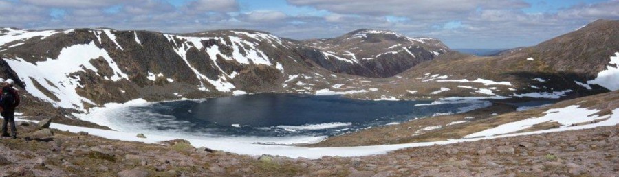
15TH NOVEMBER 2021 Black Hill
Photos
An amazing day of good autumn weather, ideally suited to enjoying this quiet unassuming glen, tucked between Esk and Clova. The morning mists and the remains of glowing autumn colours added their mystique to the familiar rounded shapes of the hills.
As in other Angus glens, tracks predominate. The ascent to our high point, Black Hill, was made easy by them and our onward walk thru the landscape ditto, although a helpful lesson for us – whose map showed which tracks? (sometimes it pays to pay the OS…)
The descent down to Water of Saughs and our first water crossing challenge – the ford…not the easiest but all over safely. Reascent and the picking up of the old path down the Shank of Donald Young, a long-felt want, as we used to say (there’s nothing like an old way), absolutely lovely; we nodded our respects to Donald, a cattle thief who died during the Battle of Saughs; the local farmer won, but Donald’s body, found later, was commemorated forever in this naming.
The highlight (depending on your point of view) was the warned-of dodgy bridge crossing; huge thanks to Malcolm for leading the way, we all managed to follow, no pictures can do it justice, congratulations and thanks to everyone – it wasn’t easy and took some nerve…
So, luxuriating in teas, coffees and fabulous homebakes at Sinclairs Larder Edzell – we agreed a great day out. Almost forgot – some wildlife – buzzard, red kite, ravens, mountain hare and lots of grouse…
Catherine Lacy
7TH NOVEMBER 2021 Walks
Poster Photos
The club had 3 walks on Sunday 7th November involving 19 club members and 3 guests. Despite the very windy conditions no-one was deterred from completing the routes which were:
Hill of Wirren 3 Trig Point Route
10 walkers gathered at Dalbog, near Edzell, despite the overnight gales which continued throughout the day for the walk led by Sandra Steel. The route followed a tarred road to Cornescorn and then grassy tracks along the south side or Garlot towards Craigangower. This part of the route was into the strong wind but where the road zig-zags up Craigangower a sheltered spot with ample space was found for the first stop of the day. Refreshed, the party set off to complete the climb up Craigangower and then to head SW for Hill of Wirren. This section was on wide tracks but the very strong side wind made for unsteady going. The wind speed was measured on this section to be 40-45 mph, gusting to 50mph. Eventually the trig point on the peaty Hill of Wirren was reached. The wind seemed a little less strong here and it was certainly much more sheltered on the way to East Wirren. After visiting the trig point another relatively sheltered spot was found SE of this hill for a second break. The route then continued over Hill of Corathro and, by another windy section, to The Crannel, where the track was left briefly to visit the third trig point of the day. A track was then followed very pleasantly downhill with views over the River North Esk and a short section of the outward route was followed back to the cars. It remained sunny throughout making for a very enjoyable day. Various wildlife sightings were made by members of the team. These included a weasel chasing a rabbit, a male and a female hen harrier, a white mountain hare, three black grouse and two red kites. The 12 mile route was completed in 6 hours. >P>Report by Trevor Stuchbury
Bennachie Area (Mither Tap and Millstone Hill)
Our group of 4 met at the Donview car park (NJ 671190) at 9:15am. The weather was fine and dry but with a strong NW wind and the forecast indicated gusts in excess of 60mph on the tops although the wind was due to ease by early afternoon. We decided to continue as planned, since much of the route was relatively sheltered and we could opt to leave out the tops if needed.
Our route headed NW from the car park on forest track around the west side Millstone Hill, through an open area of felled forest then into woodland to cross the Gordon Way at Heather Brig. From there we headed north up a steep path towards Mither Tap, leaving the woodland and crossing open heather moorland and experiencing the full force of the strong wind. The only wildlife we saw all day was a flock of geese straining to fly into the headwind! We stopped for a break in a sheltered spot below the summit of Mither Tap before descending SE on the main path towards the Visitor Centre and back into the shelter of the woodland. We joined the Gordon Way and headed back towards the Heather Brig, passing the ruins of the Colony, a community of farmers who unofficially occupied common land in the early 19th century.
At the Heather Brig we took the path to Millstone Hill (confusingly sign posted as Bennachie Donview) and stopped to chat to an Australian couple who were exploring the area for the first time and we shared other ideas for local walks. By the time we reached the top of Millstone Hill, the wind had eased. We had another break before heading down the steeper and more direct route to the SW, arriving at the car park around 3:30pm.
This was a fine walk with great views covering 12 km, 560m of ascent and a time of 5 hours.
Report by Geoff and Chris Weighill (Walk leaders)
Carnferg, 525m
An extremely windy forecast had the intrepid group of 8 walkers, including 3 guests, make a quick change from the reccied route up Peter Hill. Up would probably have been fine, but down through the peat hags was probably taking a bit too much risk so we drove down from the watermill parking area to the car park at the end of the road leading to Birse Castle. As we about to set off, a car full of folk drove up and introduced themselves as newcomers to the club - a bit of surprise, first that they had not let anyone know they were joining the walk, and second that they had found us at our new starting point. After introductions (they all seemed to be called ‘Jane’) and lots of wary chat along the line of "er, are you sure you are walking with us?” it turned out that they were newbies to another club who were also meeting at this car park, possibly Aberdeen Hillwalking Club, although they weren’t too sure themselves! Anyway, some other walkers arrived and we set off to walk anticlockwise up to Carnferg via Glencat; that didn’t last long, as the walk leader managed to miss the (almost unmissable) track and instead we headed clockwise up, via the aforementioned Castle. It was a truly delightful day, very sunny and reasonably warm for the time of year, but as we ascended so the wind picked up and the walkers queued up to thank the group leader for his wisdom in walking clockwise with the wind behind us up the Fungle Road to the summit (some of the last sentence is rather fanciful).
We summited after 2 hours walking, and were grateful for the shelter of the cairn built around the trig point where we lunched and took in the quite magnificent 360 degree panorama, not a cloud in the sky. The snap shows the intrepid 8 clinging on for grim death and the pyramid-shaped memorial cairn built to commemorate Joseph Robert Heaven by his heartbroken widow and also in beloved memory of their son Robert Edward Heaven. The return through Glencat was easy enough, all on track, and it was here we encountered the only wildlife on the walk - some cattle and very noisy dogs, thankfully they were in pens. Just over 4 hours, just over 15 km and we retired to the Finzean Farm Shop for a well earned afternoon tea. A good time was had by all, hopefully there will be three new CHC members soon!
Report by David Gair (Walk Leader)
25TH OCTOBER 2021 Geallaig Hill
Photos
Yet another forecast of wind, a theme of this autumn…however the gentle start along road was fine, followed by easy-going track to Blairglass, an ancient 15th century but recently abandoned settlement (in 1980 – they’d left my sun lounger and a bicycle behind). Despite being chased up the track by another walking group (another continuing theme of my walks), we managed to find the cheese press, the remains of the horse mill and the lime kiln, before bog led to the next abandoned settlement, complete with water mill and houses, and the Macdonald Aisle, burial place of this outpost of the clan over many centuries.
We left these old outposts behind as we climbed the relatively modern track up Geallaig, past the shooting butts, to the summit - hampered by the strong winds, but with the benefit of the fantastic low-lit views of familiar hills of the Dee valley. The lovely descent south, dropping through beautiful pine and birch forest, was wonderful, and the walk through the chicken fields a first for me – wonder where they sell the eggs?
A hello to Crathie Kirk, again a first for those of us not Royal followers, then easily over the road to the start. A good hill day out, and great to share tea and scones after in Ballater. Many thanks to those who came, those who drove, and those who will kindly forget any statements from the organiser about where we were on the hill at any point!
And finally, for the older reader – write your pin number down somewhere safe but available. Too much contactless leads to memory loss…enough said…(yes I went shopping at the Bothy!)
Catherine lacy
10TH OCTOBER 2021 Walks
Poster Photos
Conachcraig Sunday October 10th 2021
A small group of 3 hardy walkers left the Crathie carpark for the ascent up Conachcraig. On a beautiful autumnal day we passed through Easter Balmoral and through the woods emerging to a wonderful view of Lochnagar.
Following the track to Gelder Shiel, we paused at the refurbished bothy for a break. This has to be the most hospitable bothy in Scotland, with the stove still being warm from a family who had stayed the previous evening and which houses not only a candelabra but also a Landseer print on the wall.
Whilst tempting to linger longer, we continued on our way along the slightly boggy path on the east side of the burn. Regaining the track, we continued up to Conachcraig with some great views of the surrounding hills.
Whilst pleasant in the Glen, I realised it may be slightly more windy than forecast when my beanie hat was blown from my head. Not lingering too long, we headed on to the Caisteal na Caillich, where we paused for longer managing to hunker down out of the wind behind a rock formation for a lunch stop with a spectacular view.
Descending north east the terrain became more challenging until eventually gaining a track at the base of Meall Gorm, from where we had an enjoyable walk back to the cars.
Graham Metcalf
Clachan Yell and Black Craig Sunday Oct 10th 2021
The promised fine weather on Sunday encouraged eight walkers to assemble in Glen Tanar to enjoy the autumn colours and a walk to the heights. Jackie and Andy, Malcolm, Graham Neish, Marijke, Sandra Steele and David Sutherland ascended Clachan Yell, Black Craig and its diminutive neighbour Red Craig while Susie walked to the watershed on the Firmount.
The browned bracken showed the advance of the seasons and the trembling aspens were still in the calm air in the glen but it was generally agreed that autumn was being held back by the unusually benign weather of late.
It was an easy walk up the glen to the eastern shoulder of Clachan Yell. Less easy was the wet and slippery slope combined with grassy hummocks and heather, here our progress slowed. At the summit the slope relented but the wind was ferocious, the final steps to the craggy top were as hard as any on the way up. Later I wondered if the shapes of the crag were causing a venturi effect as the wind elsewhere on our walk was much less even on the slightly higher Black Craig.
The going over the hills was never easy but the views of the surrounding countryside were splendid with even the fertile areas of Glen Tanar showing a bright green while the higher hills awaited the snow.
The way home down the glen was long and hard on the feet but always interesting as the next bend was never too far away.
I was the leader for this walk but many thanks to my fellow walkers for their companionship and for keeping me on the right track.
Malcolm Smith
Driesh & Mayar Sunday October 10th
An old favourite, the 2 Angus Munros of Driesh & Mayar attracted eight of us despite the longish drive amid some fuel shortage concerns…Keeping to the now traditional route of beginning with Corrie Fee (Graham M informed us this is a relatively recent development only made attractive by the path work) we enjoyed the wonderful views of the hills and the waterfall, but maybe not so much the impressively large group of walkers from Glasgow whose path we crossed and recrossed for the rest of the day.
In fact the walk was busier than the Lake District. I’ve never seen so many people on a Scottish walk, except Ben Lomond in the summer (Ben Nevis shrouds itself in cloud whenever I set foot on it which at least hides the crowds!). Dogs too everywhere, Covid has a lot of answer for – not all were well-behaved, guard your sandwiches and mind your feet…
Still, after lockdown, wonderful to be in the hills, and to appreciate how impressed our 2 visitors were with the walk. And the rain held off bravely, just a heavy shower as we exited Driesh, and a little pattering on reaching the carpark. A good day out. Am trying to feel pleased so many people are taking to the hills!
Catherine
1ST - 4TH OCTOBER 2021 Knoydart Weekend
Photos 1
On Friday 1st October, 13 club members drifted into Mallaig and were confronted by horizontal rain and wind sweeping across the town. The Western Isles ferries had been cancelled for the day due to the weather conditions and most of the group were holed up in a local café. Suddenly, our fairy godmother (Cara) cast a spell on a local boatman who came to our rescue and transported the group over the water to Inverie.
We were dutifully met at the pier by Cara and all our gear was taken up to "The Gathering". 6 of the party were located at Ivy Cottage, a very nicely furnished residence in the vicinity. A hearty meal was taken in the evening at the new "Lookout" restaurant next to The Gathering which was washed down by quantities of Skye Gold ale.
On Saturday, following a traditional Scottish breakfast, the walking groups set out for various destinations. The main group set off north towards Beinn na Caillich ( Corbett 785m). After a bridge crossing at Folach, Sandra, John A and Alison headed north-east to conquer Ladhar Bheinn (1020m), one of the 3 Munros on Knoydart. Other objectives were Meall Buidhe (946m), another Munro and a coastal walk to Sandaig. At one point the Beinn na Caillich party decided that they had not had a decent wash so waded across the Abhainn Bheag, a raging burn after all the recent rain. Ok for those with "dry socks"( on my shopping list). Refreshments were taken at Mam Li, a prominent bealach below the east ridge of our hill. The weather was a bit wet and windy but certainly not as bad as forecast. After reaching the summit the group descended via the south-west ridge of the hill. The latter part of the hill involved picking our way down through the crags before reaching the welcome sight of the bridge over the Ghuiserein and back to base. An amusing encounter en route with our boatman for Sunday lifted our spirits.
On Sunday,a local boatman was hired to take most of the group down Loch Nevis to Tor Cruinn. The weather continued to be a major topic of conversation with varying degrees of optimism and pessimism. The aim had been to climb Ben Aden, a much vaunted Corbett or Sgurr a choire- bheithe ( another Corbett) to the north of Ben Aden or possibly Sgurr na Ciche ( Munro 1040m). In the end none of these hills was feasible given the prevailing weather and the time available. Cara had suggested walking back to Inverie via Mam Meadail and Glen Meadail. A somewhat boggy walk but probably a sensible option in the circumstances. This included a visit by some of the group to the prominent Brocket monument (erected by Lord Brocket, a past landowner and nazi sympathiser. Naturally, it provoked a certain amount of discussion particularly in an age when such monuments are under close public scrutiny.
All-in-all, another exciting CHC trip to one of Scotland's finest remote locations. We will be back! Thanks to all for taking part in the adventure.
John W
List of walks
Beinn na Caillich (785m)
Ladhar Bheinn (1020m)
Meall Buidhe (946m)
Inverie to Sandaig
5TH SEPTEMBER 2021 Walks
Poster Photos 1 Photos 2
Peter's Hill by John Adams
A group of five (Peter S, Sue, Lorna, David R, John A) set off in bright sunshine from the Ballater car park to find the "cinder path" behind the old railway station. This well used path skirts the games park and took us to the Pass of Ballater where, after a short distance on the road, we turned into the forest and headed up the landrover track. A steady pace allowed for conversation on the ascent and in no time, we cleared the trees to see Morven ahead and the Tullich Burn far below. Lorna having recently completed a navigation course was keen to consolidate her skills, so at each turning point we took bearings and checked the map (to discover that we were indeed still on the right track!).
Morning coffee was at a small lochan near the junction to the transmitter on Sgor Buidhe. Two unusual straw platforms were standing in the water, presumably to encourage wildfowl nesting. After the break we headed back to find a narrow track that led up through the trees before emerging at the first top of the day, Creagan Riabhachm, where there were excellent views for such a modest hill.
Continuing on various tracks we lost a little height, raised a pair of grouse (the only ones seen on the route) before branching right and then heading up beside grouse butts to the top of Peter's Hill. With no wind this was the perfect spot for a break and being Peter's Hill, Peter was given a seat on the cairn. Over a leisurely lunch we enjoyed wide ranging views of Lochnagar, Mount Keen and Morven.
Another navigation check confirmed that the next leg of our route was down over burnt heather to the top of the Glen Bardy track. This track descended in a long curving arc to reach birch and juniper cover as we crossed the burn. Contouring the hill on a grassy track we had good views initially of Glen Gairn and then up the Dee as we reached the open fields by Abergairn.
Arriving at the road, we crossed the A93 and dropped down to the former railway track by the Dee to finish our route to Ballater. Arriving at the car park a visit to The Bothy for refreshments was agreed. Lorna's navigation skills were demonstrated again as, compass in hand, she guided us to the cake selection for a delicious coconut and chocolate treat. A very enjoyable day in perfect walking weather and with great company. We covered 16km with 540m of ascent in 5hrs 30 mins.
Tolmount and Tom Buidhe by Graham Neish
The question was, "Would the great weather of the previous two weeks hold for the September Sunday CHC walk?". The answer was - it did!
Seven members met at Auchallater car park at the rendezvous time of 8.30am and found it not too busy considering the good weather forecast. We followed the Callater Burn upstream for 5km on the good track to Loch Callater Lodge and Stable. The stable, now a bothy managed by the Mountain Bothies Association, was found to be immaculately clean and tidy upon inspection. Outside in the sunshine we had our first refreshment stop of the day.
From here we steadily trundled up the side of Loch Callater on Jock's Road, muddy in places and sometimes difficult to follow, but the views over to Coire Kander were superb. Wild campers were also spotted on the flat, sandy, southeast shore of the loch-a lovely place to spend the night in favourable weather conditions. Once the bealach was reached we stopped for another refreshment break before we continued steadily to the summit of Tolmount.
The temperature was certainly cooler on the summit and additional layers had to be worn to keep the cool breeze at bay. The views from here were once again enjoyed by all before we set off south, southeast to the second Munro, Tom Buidhe. This hill is virtually the same height as the previous one, so without any steep descent or reascent, we reached the summit in approximately half an hour.
After enjoying our time on the second Munro, we set off on our homeward journey, stopping for a break overlooking the lovely Coire Loch Callater. The view down into the Coire was truly magnificent with a large herd of deer spotted, tucked into the far side. Numbers were difficult to estimate, but there must have been around 50 -70 of them.
From here it was all downhill to the lodge and the walk back out to the starting point. The highlight was a hearty wave from the driver of a passing new Range Rover which was being driven out the glen at quite a brisk pace, the driver being Prince Charles!
Thanks to all for making the effort to tackle this 28km route in just over 8 hours. A very good hill day was had by all.
6TH-9TH AUGUST 2021 Glenmore Lodge Weekend
Photos 1 Photos 2
Culter Hillwalking Club's Long Weekend at Glenmore Lodge, postponed by COVID from 2020 finally took place from August 6-9th 2021. Fifteen Club members attended with an additional two non-walking club member spouse/friends. With a weather forecast of thunderstorms predicted for the arrival date, few took to the hills on the journey to Aviemore, though some took lower level walks in the Aviemore area on arrival.
Members were accommodated in a mixture of single en-suite rooms in the older part of the main lodge, and four couples in the four lodges, in order to comply with COVID single household occupancy regulations. Dinner, canteen style, for all was in the restaurant and the quality and quantity of food was excellent served by some very cheerful kitchen staff. The bar was open upstairs with just time after dinner for a drink or two and some walk route planning for the following day.
The Saturday eleven members had booked into a scrambling course with three guides from Tarmachan Mountaineering. Rendezvous point was the main Ski upper car park, a midgey spot with little breeze, from where all three groups took the regular path into Coirie an t-Sheachda (corrie of the snow). With climbing harness and helmet the "warm-up" (aka fast learning) scramble was up the "Twin Ribs", with the choice of taking the rocks and outcrops head on (which we did) or veering off to the side and more or less walking up the slopes. Once at the top it was an easy walk with boulder hopping along the fairly level lower section of the Fiacaill Ridge.
A stop for a good refreshment break allowed time to enjoy the views as a drizzly shower passed by but then it was head on to the much steeper section of the ridge. We had frequent discussions about which line to take, what challenges the rock created, what "exposure" there was and what would be the severity of a fall, what alternatives looked feasible (and easier!!), what we might find beyond our field of vision, and could we retreat if we came to an "impossible" section. Our guides were easily capable of surmounting all that lay ahead and from above could advise on hand and footholds, and if necessary attach us to a rope for added security, there were many situations where slipping or loosing grip would result in a seriously unfavourable outcome. The ridge line required Grade 2 verging briefly on Grade 3 (anything above that is proper "climbing") where the gradient was close to vertical, both hands and feet were employed in finding suitable holds on the rock face in order to gain upward movement, and there was considerable exposure around. After a series of many such scrambles interlaced with discussions on line and technique we reached more horizontal ground and reverted to walking.
Our return was back into Corrie an t-Sneachda down a path known as "the Goat Track", a very appropriate name, it was steep and well eroded by use. But before that we stopped an had a half hour lessons and practice on basic rope knots, methods of belaying and abseiling.
We returned to the cars, content that we had actually traversed the Fiacaill Ridge and now had sufficient knowledge of scrambling to tackle more or less anything we might encounter on our Club walks,
On the Sunday, and the Saturday for the "non-sramblers", and for some the return day, Monday, a wide variety of hills were tackled either from our very conveniently located accommodation, a short drive to the Ski car parks, or longer drives to Glen Eanaich and Glen Feshie. The following is a list of some of them:
Meall a Bhuachaille - Creagan Gorm - Craiggowrie ridge
Ben Macduie and Cirn Gorm
Braeriach via Loch Coire an Lochan & Sron na Lairige from Gleann Eanaich
Bynack More and A' Choinneach
Mullach Clacc a'Bhlair and Sgor Gaoith from Glen Feshie
Stob Coire an t-Sneachda
Carn Etchechan via the Feith Buidhe slabs, Loch Etchechan and the Shelter Stone
Creag Dhubh & Cadha Morand the Argyll Stone from Gleann Eanaich
And others took shorter lower-level walks amongst the corries and various lochans in the area.
The weekend was a long time in coming, but well worth the wait.
1ST AUGUST 2021 Walks
Poster Photos
Angel's Peak and Cairn Toul
A select group of four assembled at 08:15 at the Linn of Dee. There was a noticeable chill in the air after the heat of recent weeks but the brisk cycle to Derry Lodge soon had us up to operating temperature. There was no loitering as the midges were about and we set a good pace to the Luibeg ford. Our early departure from home called for an early break and the rock outcrops on the lower slopes of Carn a'Mhaim provided the ideal spot.
As we rounded the slopes into the Lairig Ghru only the highest tops were in cloud and, with an improving forecast, we were hopeful that the tops would clear by the time we reached them. About 3km beyond the Corrour junction, we struck out across rough grass and heather towards the entrance to Garbh Choire. Our route required several crossings of the fast-flowing tributaries of the Dee. The boulders in the burns were frustratingly far apart but we did manage to find suitable crossing spots to get over with dry boots. We then picked up a path towards Garbh Choire Refuge and could now see our first hill, the Angel's Peak with the impressive NE Ridge towering over 500m above us. The Garbh Choire Refuge is a small stone-built structure which turned out to be surprisingly dry and comfortable inside having been completely rebuilt by the MBA in 2018. After a quick lunch we set off up the steep slopes behind the refuge to emerge into Coire an Lochan Uaine with great views above the lochan to Cairn Toul and Angel's Peak and across to Braeriach and the Falls of Dee.
After a few photos it was off across the boulders to start the ascent of the ridge. Initially there were hints of paths but as the ridge narrowed and became steeper it was just a case of following the best line through the rocks ahead. Only a few places had awkward moves and it was clear that long legs were an advantage. Our sudden arrival at the summit didn't lead to the panoramic views we'd been expecting as the clouds had descended as we had climbed. However, it was still a very dramatic approach to the summit. We were greeted by a couple of other walkers and by a fleeting view of a snow bunting (the only notable wildlife sighting on the trip).
By the time we reached Cairn Toul the clouds were lifting and for the remainder of the day conditions steadily improved with warm sunshine and extensive views. Devil's Point, which had been considered an optional extension, was now agreed to be in scope as it looked an almost flat addition from our viewpoint on Stob Coire an t-Saighdeir. Inevitably we found that there was some ascent to reach the Devil's Point but it was worth it for the dramatic views in all directions and was a great spot for a break.
The descent to Corrour Bothy was surprisingly fast on the well graded path and after a quick look inside and chat to the occupants we set off on the return route. We had a final stop on the same rock outcrop that we'd been on some eight hours before and then crossed Luibeg burn and set off for Derry Lodge and our bikes. The cycle back in the evening sunshine was a delight as very little effort was required for most of the return. We arrived back at Linn of Dee about 7:45pm for a hurried change of clothes as the midges feasted on us.
A great day out with a total of 39km (of which 10km cycled), 1,580m of ascent and a time of 11 hour 25 mins.
4TH JULY 2021 Walks
Poster Photos
Ben Iutharn Mhor and Tops by Geoff
This was the 3rd year that Beinn Iutharn Mhor (Munro 1045m) and neighbouring tops Mam nan Carn and Beinn Iutharn Bheag had been offered on the Sunday walks programme, having been cancelled in 2019 due to bad weather and 2020 due to COVID restrictions. The circular route from Inverey used bikes as far as the Altanour Lodge (ruin) to tackle the long access track.
Our group of 4 met up at the Inverey car park at 9:30 and the weather was dry, mild and overcast with light winds. Despite the mist and drizzle over much of Deeside, the Met Office forecast showed improving conditions with clear tops after midday but with possible showers later in the afternoon.
Our group set off on bikes at 9:45 and covered the 9 kms on the rough and bumpy track to the Altanour Lodge in about an hour. The woodland by the lodge is undergoing restoration and is surrounded by deer fencing with wooden slats to deter low flying birds. After a short break and securing the bikes, we set off SW following the Allt Beinn Iutharn, first on rough tracks and then on indistinct paths along the river terrace to the base of the NE spur of Beinn Iutharn Mhor (BIM). The top of the hill was shrouded in cloud but this dispersed as we climbed steeply up the spur and the weather turned warm and clear. Once the slope became less steep, we took a short break with fine views to the NE along Gleney.
We continued to the ridge over short heather and grass and saw the profile of a deer in the distance. A bit later, 2 deer appeared not far ahead as we plodded upwards but they wandered off without apparent concern – clearly, we weren’t a threat! Once on the ridge, the terrain became stony and we made our way towards the summit, above the steep slope down to Lochan Uaine. We reached BIM summit (1045m) around 1pm and after a short break, headed south over the flat, stony plateau then down to the col before climbing to the rounded top of Mam nan Carn (986m). From there, we headed NE along the ridge above Loch nan Eun to another col before the final ascent of the day to the rugged summit of Beinn Iutharn Bheag (953m). Wildlife in the area was scarce, except for some small birds and a lone mountain hare in its brown summer coat.
After a short break, we headed N and descended the steep grassy slope to cross the Allt Beinn Iutharn Mhor below. We then followed the burn on indistinct paths before re-joining the track to Altanour Lodge and the bikes. After a much faster, albeit very bumpy ride, we returned to the car park around 5:30pm with still no sign of any rain! We covered 31km (18km on the bikes) in 7 hrs 45 mins with a 880m total ascent. A great day in the hills, all the better for the surprisingly fine weather!
Balmoral Cairns by Jackie and James
Sunday July 4th one of the Culter Hillwalking Club’s walks on offer was a repeat from the previous month, Balmoral Cairns, a classic. So popular was the walk that two walks were held, separated by half and hour (and they never bumped into each other!!).
The 9.30 group of three (two participants having to drop out at the last minute) left the Balmoral Car Park Visitors Centre at 9.30 am with the dreich weather having been left behind at Ballater. The 10.00 group drove through a torrential downpour in Aboyne but by the time we reached Crathie the weather was fine. First point of visit for both groups was John Brown’s grave at the Old Crathie Kirk (ruin). A local man, he was buried locally alongside his father with similar headstones, though John Brown’s had been given a facelift.
A stroll down the road took us to the white suspension bridge over the Dee to Easter Balmoral (the bridge presumably built so that south-of-Dee dwellers could get to church for services and prayer). We followed the usual track up through Easter Balmoral and out into the woods, but soon took a well defined (if you are looking) path off to the left that ascended to our first true cairn, Beatrice’s Cairn. A routine for each cairn was developed – photos, walk round it, admire the views, and head on to the next, which in this case was the impressive Alberts Cairn. More of a pyramid, than a cairn, it was beautifully built in masoned granite by Queen Victoria “To the beloved memory of Albert”.
Wanting to add some off path, navigationally challenging elements to the very popular Balmoral Cairns Walk, the Princess Royal’s Cairn was injected into the list. This longer walk needed a refreshment stop along the way, shortened somewhat for the first group by a few bloodsucking midges that emerged in the still, humid air, while for the second group it was flies that were the problem. The cairn was located on top of Canup Hill, our highest point at 451m, in the midst of the Woods of Garmaddie. The hill had some seriously steep slopes on its eastern flank, but we skirted round those on a vague path before reaching the summit with some fine views back down the Dee. We descended by another vague path through the trees before getting back onto the vehicle track, leading round towards the Dee and the buildings at Invergeldie Lodge. The first group decided to stop for lunch just as a short, sharp shower hit them, but a large tree afforded them shelter. A red squirrel entertained them as it ran down the road and then under a tree, for it too to gain shelter.
Post lunch was one cairn after another, Alice’s, Arthur’s, Leopold’s, and on to the rather special Purchase Cairn, commemorating the purchase of Balmoral Estate. Then back to Victoria’s children’s cairns, Louise, and Helena. The second group spotted an impressive ant hill between Alice’s and Arthur’s cairns. It was up and down amongst the forest in which the cairns were easy to miss, often tucked away on a side path. Careful navigation was required in order to avoid wandering around the minor hills all day long. We also built in a visit to John Brown’s pink granite bench, and close by his statue, looking very proud. The first group bumped into and chatted with the retired head gardener of 22 years who told us many a story, particularly how Victoria had erected John Brown’s statue near the Castle but he was generally not well liked (except by Victoria) and the statue was moved away, first to somewhere near the current golf course, and then to the statue’s current position.
The second group headed out past the cricket pitch (where one member of the party who belongs to the Dunecht cricket club had been playing cricket against Crathie the previous day) to the Diamond Jubilee cairn and then back along the river. The first group didn’t make it to the Diamond Jubilee Memorial, nor the café but headed home in time for some early evening appointments, but our 17km walk with 630m with 630m vertical ascent had been most enjoyable.
Morrone Circular by Sandra Steel
5 walkers started our walk from a layby 2.5 miles SW of Braemar. The forecast was for showers in the morning and due to clear up in the afternoon. As it was, we had no rain and had beautiful sunshine all afternoon.
We set of through Morrone Birkwood to the viewpoint in overcast conditions. We stopped for a few minutes wondering what had happened to the dead mole in the underground just off the path.
Continuing up the steep ascent to the summit, the cloud cover began to lift, and enabling us to have a lovely coffee stop at the top, with good views. Before we headed off we were joined by a Mountain Burnet Moth.
Having joined a Zoom Talk by the Butterfly Conservation Organisation last year I immediately recognised it by its bright red spots. It only exists in a few places in the whole of the UK, so we all felt lucky to see it. (Editor’s note: I saw one in Cornwall near Lands End this month)
Having stayed dry all morning, the threatened rain coming to nothing the cloud lifted to give amazing 360 degree views all around.
Continuing on the path over the top of Morrone we saw another half dozen different sighting of this Moth.
Conditions must have been perfect for it.
The route took us southwards over Carn na Drochaide, then over Carn Mor before heading west to pick up the path marked on the OS map. We surprised an Adder and it quickly darted into the undergrowth before we could get our cameras out.
We also spotted a few very large groups of red Deer. Continuing on we headed down the col between Tom Anton and Carn Mor which is part of a fault line which runs from Glen Gairn to Glen Tilt. This col may have been a meltwater channel. More deer were spotted on the skyline, this time mainly Stags. After another stop we headed down to the Lime Kiln and Hydro Scheme at Corriemulzie Burn, before finally heading back through the woods and back to the cars.
We all agreed we had a fantastic day, excellent walk, great views and super company.
26TH - 27TH JUNE 2021 Lochnagar midnight ascent
Photos
July 26/27th was the night of the COVID postponed Club night time ascent of Lochnagar guided by Balmoral Head Ranger Glyn Jones. Five hardy club members met up just before midnight at the surprisingly busy Spittal of Glen Muick car park and followed the very familiar vehicle tracks across the glen to Allt na Giubhsaich, through the woods, where the tree cover made it significantly darker, then back onto the rough, eroded vehicle track. The burn crossing was easy after the recent dry spell and after a little effort we were at the highest elevation of the track, just where the Lochnagar path turns of left uphill.
We stopped for refreshments and as planned Glyn arrived in his vehicle from the opposite direction, from Balmoral Castle. He lead us up the recently refurbished path that should minimise walkers taking many different paths and damaging the hillside. We reached the bealach by Meikle Pap and were able to look across to the crags and snow patches of Lochnagar, illuminated to some extent by the moon which had risen in the east for a brief appearance between bands of clouds. In other directions cloud was developing in the valleys under temperature inversions.
Glyn was the perfect guide to find the subtle route through the boulder field, known as the Ladder, leading us onto the summit plateau and onto the edges of Lochnagars crags. The sky was already brightening up to the north. Finally we reached the true summit where unsurprisingly we were not alone, a total of around 15 people and uniquely, two pitched tents. There was no wind, the air was absolutely still and as a result there was total silence. For a location that has always been windy on all and many previous visits, it was hard for the brain to process.
Sunrise was at 4.20am (03:20 UTC) in a north-easterly direction and although there was only a brief period of "red sky" and ongoing bands of cloud hid the sun itself, it quickly became lighter and lighter.
We made our descent by the alternative route down to Glas Allt Shiel, stopping at the new bridge (and more new path) above the waterfall to say farewell to Glyn, who was short-cutting across the hillside to his vehicle, whilst we descended down to Loch Muick. The surface of the Loch was glassy smooth in the windless conditions reflecting perfectly the steep hillside behind so that the two became one flat image in the still dull light. It was impossible for the eye to find anything on the actual surface of the water on which to focus, and thus it was invisible, undiscernible. Perhaps the the brain was getting tired of natures tricks, or perhaps just getting tired.
It was an easy walk along he loch and back to the car to have covered 18km. A unique experience.
17TH - 20TH JUNE 2021 Loch Carron Weekend
After a very wet weekend in Loch Carron 5 years ago, we were all hoping for better, and we got it – glorious sunshine and amazing views predominated (I’ll not mention the 60mins of rain only endured by a party of 3 on a single day). The Loch Carron hotel was as welcoming as ever, Nigel and his family provided excellent if individualistic service, and the walkers did themselves proud: this is not one of the huge iconic areas all walkers flock to, it has challengingly rocky summits on one side of the glen, opposed by mega walk-ins on the other. As a result, the following summits list may seem meagre - but it actually represents a huge amount of activity.
Munros
Maol Chean-dearg
Beinn Liath Mhor
Sgorr Ruadh
Sgurr Choinnich
Sgurr a’Chaorachain
Moruisg
Maole Lunndaidh
Bidein a’Choire Sheasgaich
Lurg Mhor
Fionn Bheinn
Corbetts
An Ruadh-stac
Fuar Tholl
Sgurr nan Ceannaichean
Sgurr na Feartag
Beinn Tharsuinn
Sgurr a Mhuillin
Meallan nan Uan
Sgurr a Chaorachain (Applecross)
Beinn Bhan (Applecross)
Congratulations to all walkers: I’m reluctant to pick out any individual but have to admit Rob and Graham achieved an extremely high level of performance on their walk to Bidean a Choire Sheasgaich and Lurg Mhor - and back in time for tea…!
6TH JUNE 2021 Walks
Poster Photos
13TH-16TH MAY 2021 Ullapool weekend
Photos
After a period of 18 months Culter Hillwalking Club held its first weekend away, postponed from 2020 to May 2021 as COVID restrictions allowed. However ongoing restrictions did limit accommodation rooms to single household occupancy, so our happy band of eighteen were scattered around Ullapool hospitality, though remaining centred on the original Moorfield Motel.
Decent weather prevailed the whole duration, with sunny mornings, and a threat of showers in the afternoon, though we all seem to have been fortunate in avoiding the showers. Some members bagged a hill during the drive up on Thursday, or went a short walk after checking in Thursday afternoon. Friday and Saturday were both highlighted by the hiring each day of two guides from Kirkhope Mountaineering, Fort William, taking 6 club members on a traverse of An Teallach, a gruelling day of 17km and 1400metres of vertical ascent but well rewarded with stupendous views in the cool but clear air.
Away from An Teallach club members tackled a huge range of hills from the outstanding opportunities of Assynt and beyond including the following:
Sgurr Fiona (An Teallach)
Bidein a Ghlas Thuill(An Teallach)
Speicein Coinnich (Ben More (Coigach)
Sgurr Fhidhleir
Sail Gharb (Quinag)
Spidean Coinich (Quinag)
Sail Ghorm (Quinag)
Breabeg
Glas Bhein
Beinn Uidhe
Stac Pollaidh
An Coileavhan (Fannichs)
Meall Gorm ( Fannichs)
Sgurr More (Fannichs)
Beinn Liath Mhor (Fannichs)
Sgur Breac (Fannichs)
A’ Chailleach (Fannichs)
Beinn Liath More a Ghiubhais Li
Beinn Ghobhlach
Beinn Dearg
Cona Mheall
Beinn Enaiglair
Sail Mhor
Ullapool Hill
Probably not an exhaustive list, but certainly an exhausting one!
With that amount of mileage and vertical ascent conquered evenings were pretty relaxed at the various accommodations and an early bedtime was called for
2ND MAY 2021 Walks
Poster Photos
Burnt Hill walk – Sandra Sutherland’s report for Jackie’s walk
We met in the car park at Glen Esk for 9.30 am and at 9.32 am the 5 walkers (from 3 households) set off. It was a popular walk on Sunday 2nd May as the car park was already more than half full of cars.
We had excellent views as we headed off; with the loch on our left-hand side, and we could see clearly, at this time, where we were heading; up to Burnt Hill, then along the ridge top to complete a circular walk. Conditions were good, dry underfoot and a clearly marked track.
As we began to climb, we could see mist ahead, but at the same time if we looked down the valley, we could also see sunshine. We began to experience the old Scottish saying of “there’s plenty of weather in Scotland, 4 seasons in one day”.
We had our first stop about halfway up Burnt Hill, lovely views of the loch on our left-hand side, views down the valley to our backs, ahead and on either side hills and above us mist, cloud and approaching rain, sleet, and hailstones.
As we reached the top at 450m and headed to the cairn just before our lunch stop, we now had jacket hoods up, gloves on and were glad of the invention of Gore-Tex.
We headed to the trig point for our lunch stop, views were less clear as we ate our sandwiches. We could see patches of snow on the hills on either side of the loch. After our sandwiches and a hot drink, we were nicely refreshed for the downward walk. Good views, some humorous jokes and for a wee while we had dry weather.
Finally, down to the farm, turned left and headed back to the car park. We were passed by 2 other walkers who quipped “Good weather for ducks.”
We all agreed that we had had a good walk, good views, and good company.
Cnapan Nathraichean – Catherine’s Report on her walk
Aware that it was the May Bank Holiday, we assembled early at Keiloch only to find acres of empty space…everyone else had clearly read the weather forecast…Nevertheless we set off on a rather different route through Ballochbuie - we stood on the padlocked suspension bridge for beautiful views of the Dee (and a dipper), and passed the shiel, being stared at by a group of up to 50 red deer, hardly put out at all by our presence; hmm, tame?
A lovely path rose through the best stands of juniper I’ve seen on Deeside, and we then threaded our way over the watershed towards Glen Gelder, before climbing steeply up to the Prince’s Stone, commemorating Prince Albert’s overnight stay in this somewhat remote area. On up to the high point of 830m and a magnificent view of Lochnagar and its satellites, their snowy slopes gleaming in the sun. The Cnapan itself is also a good viewpoint; then we descended to the new deer fence to follow the path west, where some of us also tackled the sadly overgrown path to the Honka hut, followed by Queen Victoria’s pony track. More tremendous views; better weather would have been appreciated but overall a great day out.
Carn an Tuirc 1019m and Cairn of Claise 1064m – Graham Metcalfe’s walk
We were due to meet in the Sean Spittal Car Park for 9.30am, though due to eagerness from all 5 walkers from separate households we were ready and underway for 9.20am. The day was overcast but with clearly visible snow on the peaks.
The route was popular with other walkers despite the forecast, with several other parties on the mountain including a couple of running couples.
Ascending Carn an Tuirc first, we crossed the snow line to then be in intermittent hail and snow showers though thankfully only a light wind. Hunkering down for a quick coffee break, we then headed along the ridge towards Cairn of Claise. The clouds lifted a little though still with restricted visibility, we reached the summit which was already occupied by another group having a break. Lunch was calling so, finding a convenient wall for shelter, we had another socially distanced break. During lunch, the clouds started to lift and like the opening of a curtain, views towards Caenlochan Glen, Monega Hill and Glen Isla became visible.
With lunch concluded and the summit now clear, we agreed to reascend at least 5 metres to the summit for a team photo and then set off keeping the cliffs on the right. The cloud lifted completely and the sun came out, with several of us rueing the reckless decision not to bring sunglasses given the reflection from the snow.
Coming across a small pond, we saw a family of dunlins having a great time playing together whilst seeking food, then left the track to head North West towards Sron na Gaoithe. By now the clouds had lifted, the sun was blazing, and the panoramic views across the Cairngorms were tremendous.
Ascending Sron na Gaoithe, we spotted a golden eagle flying in the distance (there was a suggestion that this may be a buzzard but that was quickly discounted as talking the walk down). Following a steep descent off Sron na Goithe with a mountain hare watching us from the horizon, we then returned to the cars after 5 hours. It was agreed this had been a super walk, with fantastic company.
Carn Aosda 917m, Carn a’Gheoidh 975m and Cairnwell 933m from Glenshee ski centre – John Adams’s walk report (with a little help from his friends)
The drive up Deeside wasn't promising with low cloud obscuring many of the hills. Fortunately, at the Glenshee Ski car park conditions were better with views up to snow covered tops. All five of us arrived within a few minutesof each other and we set off on the steep ascent up through the ski area towards Carn Aosda. Nearing the top jackets were donned as the cloud had descended and we found ourselves in driving snow and hail on cresting the hill. Following a brief photo stop at the cairn we were quickly underway again. Leaving the track at one point we found ourselves in full winter conditions. A course correction led us back to the planned route and before ong visibility improved enough for us to see the second hill of the day, Carn a'Gheoidh.
Seeking protection from the north winds we found a small gully above Choire Dhirich which offered shelter. Over coffee we admired the views and noticed a network of white lines cutting across the slopes of Cairnwell where snow lay in the deer tracks. Moving on we had a clear path and undulating terrain all the way to Carn a'Gheoidh. By now the weather was much improved with extensive views of the snow-covered Cairngorms from Braeriach to Ben Avon to the north and all the way to the Lomond hills to the south. Another refreshment stop was called for as the conditions were fine and shelter available.
On the return we diverted to Carn nan Sac where a substantial cairn lacked any flat surface capable of supporting a camera for a group photo. Jo's persistence paid off and a group photo was finally obtained (without any camera damage). The cairn is a good vantage point with views across Choire Dhirich to Cairnwell and also down the glen to the Spittal of Glenshee.
A special request for the return was a visit to the highest lochan on our route (867m) where Jo enjoyed a "stimulating" paddle. Unsurprisingly the others in the group didn't feel that the conditions warranted a paddle. From here the route continued with a high-level circuit to Cairnwell where sheltered southern slopes provided another good vantage point. While there, a pair of ptarmigan in grey and white plumage landed close enough for a few photos.
Returning to the route we stopped at the top of the chair lift and chatted to the operator outside his cabin. He was a quite a character and talked to us until he could no longer ignore a shivering family waiting to be allowed to reboard the chairlift to get down the hill. Reluctantly we left our high-level circuit and headed down the track to the car park, passing a couple of mountain hares on the way. Like the ptarmigan they were halfway between winter and summer coats. Reaching the cars, we had completed 15.6 km with 700m of ascent in 6 hours. A fine hillwalking day in excellent company which a few of the group extended by stopping at the Bothy in Braemar.
Greenhill, Strathdon, 570m – Geoff Weighill’s report on his walk
Our group of 6 met at the Strathdon car park opposite the ancient ‘Motte’ (NJ 352129). The forecast indicated cloud in the morning with light northerly winds and temperatures up to 7 deg.C but rain likely in the afternoon. We had arrived during a heavy shower but this soon cleared and we set off in brighter conditions around 10am.
Our route took us NW from Strathdon along a minor road and track, passing the farm at Lost then along the edge of conifer plantation. We took a short break on an open bank, overlooking the bend in the Water of Nochty, and had fine views across the farmland and Ladylea Hill to the N. In the distance to the NW, we could see a tower on the hillside at the site of an old walled garden of the now demolished Auchernach House.
We continued on the track over the fine stone Bridge of Auchernach, then headed W along the Water of Nochty through an area of felled and replanted conifers before emerging into open farmland around Tolduquill. From there, we followed a rough path around the farm buildings then across open moorland to join a rough track above the steep gorge of Quillichan Burn, passing through an extensive area of low lying juniper trees. We continued through the gorge and eventually joined a wide estate track near a shelter before having our lunch stop outside the distinctive octagonal shooting bothy by a pleasant lochan. Wildlife was sparce on this stretch of the walk although we did hear the distinctive call of curlew over the moorland as well as other small birds that were too fast to identify.
After our lunch stop, we headed NE uphill following the boundary fence toward the rough crags of Knapps, where we had fine views looking back over our route that morning. We continued over rough heather to Red Craig then onto Greenhill (570m) where we noted a boundary stone by the gate but no summit cairn. From here we had excellent views across to Morven, Lochnagar and Ben Avon with snow cover on the summits in bright sunlight.
We then headed SE downhill and joined a rough path, taking us around the shoulder of Breagach Hill and down a pleasant grassy track with fine views across the Water of Nochty. The weather had brightened up and the rain held off as we headed through conifer plantations, then into open woodland with tall beech trees before cutting down to join the marked trail back to Strathdon, arriving at the car park around 3:30pm.
This was a fine walk with great views covering 15 km, 330m of ascent and a time of 5.5 hours.
Ripe Hill 519m – James Brownhill’s walk report
Three households turned up at the Balmoral car park visitors centre for the circular walk up Ripe Hill. Considering a forecast of 40% chance of showers it was disappointing that the sky was overcast with steady rain, so waterproofs were donned from the very start. The route took us past the ruins of the old Crathie Kirk, where Queen Victoria’s faithful servant John Brown is burred, probably also for the reason he was born in Crathie. The suspension bridge, significantly wide enough to take a horse and carriage, took us to Easter Balmoral and onward to the well-trodden landrover track towards Gelder Shiel. With the gain in height the rain took on a sleety nature but was never unpleasant. A group decision was made of whether to stick with the planned route, take a looping diversion to Gelder Shiel or just take a “there and back” diversion to the shelter. The latter was chosen and although everything was locked up as expected, there was a very functional (but cheap) lean-to with bench seats where we enjoyed our picnic lunch and drinks. By the time we had finished the cloud was breaking up to give us views of the relatively close, Lachnagar, clad in fresh snow, and to the north west Beinn a Bhuird, impressive when the sun reflected brightly of its expanses of snow.
One member returned to the car park the way we had come, the remaining three headed on track generally northerly enjoying fine views of the recently popular hill Cnapan Nathraichean to our left. Crossing the Gelder burn was the signal to turn off track and heather-bash to the foot of the slopes of Ripe Hill, easy going as the ground was so dry. Our ascent was relatively brief, taking us through a section of windfall timber amongst which were some active wood ant nests giving off a stringent pong of formic acid that the ants produce and squirt to warn off any intruders, and it is believed also to disinfect their nest. A black cloud gave us ten minutes of continuous soft hail stones (official name is “graupel” of Germanic origin) but was not unpleasant as we reached the diminutive summit cairn of Red Hill at 519 metres. An intuitive stroll along its forested broad summit shoulder brought us to the main attraction, the cone shaped, granite Prince Alfred’s Cairn and Memorial built in 1874 to commemorate the marriage of Alfred, Duke of Edinburgh and Marie, Duchess of Russia that took place on 23rd January that year.
Our route off Ripe Hill, where there was no sign of any regular path of ascent or descent, was on a northerly heading to a well maintained landrover track running East/West. At this track one member turned east, and homeward, whilst two of us turned westward following the track which headed into the forest and downhill towards the Dee. We spotted a whole string of wood ant nests on the edge of the forest in a position to catch as much of the sun’s warmth as possible.
Back down into the softness of the Dee valley we decided to go off the Balmoral tarmac and follow the riverbank downstream as close as possible on an occasionally used landrover track. However we were baulked by a fording of the Gelder, and rather than get we feet, side tracked upstream through a couple of fields to cross by the official tarmacked bridge. Immediately after, despite our recent experience, we took anther track to the riverbank and was able to follow that to Balmoral Castle. Noticing the restaurant was serving through a hatch we stopped briefly for a tea/coffee before heading out to get a full frontal view of the Castle. A brief detour to the vegetable garden, immaculately prepared but showing little sing of growth after such a cold month of April, lead us down the drive to the main Balmoral gate, then over Crathie bridge to the car. 19km, 390 metres of vertical ascent, a great walk to loosen up the COVID locked down muscles.
Saunter round Loch Kinord
The weather continued its pattern of showers but thankfully these didn’t include hailstones today. We chose to do a complete circle anti-clockwise starting from Burn o’ Vat which wasn’t too busy when we left at 10am. As we left, it started to rain, not heavily, but nevertheless wetly. Throughout our walk, we saw quite a few people, including a number of dog walkers, horses and quite a few geese as well. To our delight, the shower cleared up on our way back up the Loch which enabled us to have a sunny lunch on the handily placed bench by the Celtic cross. On our return to the car park, cars were lining the road once again, but a number of cones had been placed along the road to deter parkers who were too late for the car park.
4TH APRIL 2021 COVID "Stay Local" walks
Poster Photos
James’s walk
Nigg Police Station was the start/finish point for four city-resident club members and one guest for this April 4th COVID “Stay Local” walk. Very appropriately for Easter Sunday the first point of interest was Nigg Kirk, built in 1828 but from long ago not a functioning kirk, believed now to be a storage facility for oil company geological core samples. Although appearing to have modern UPVC windows either side of the nave, on close inspection these are complete fakes being metal sheeting painted rather skilfully to look like windows. It was not determined what was behind the metal sheeting.
It was a short walk across the dual carriageway to the entrance to Kincorth Hill nature reserve. Being a bright, partially sunny morning, but with poor weather for late afternoon, the hill was busy with local dog walkers and many more. It was a direct ascent on wide, easy walking gravel paths that raised our temperatures somewhat, before briefly heading “off-piste” to visit the trig point, on a lightly elevated earthen mound and listed as a lofty 105m, one of our hills for the day. Another slight detour, on path, took us to a viewpoint, which did exactly what it said on the tin, good views of the city from an unusual angle. To the north over the city the beach stretched away; we discerned Elrick Hill and Tyrebagger Forest to the northwest, the flat topped Hill of Fare to the west, and snow-capped Deeside peaks to the southwest, but we were unable to ascertain if these included Lochnagar.
We left Kincorth Hill by a “backdoor”, single track sometimes muddy path that wandered through heather and gorse to the second hill of the day Craighill, notable for a moderate stone cairn and GPS measured hight of 97m. We could hear the rumble of traffic speeding up the close-by A92 from Bridge of Dee but it lay out of site due to the contours of the hill. More distant though we could see southwest to Banchory-Devenick and south to the Charleston Flyover, the city end of the AWPR and the city boundary which we were not allowed to cross. We stopped for refreshments a good while before taking a tortuous route through invasive gorse onto track, and our first experience of tarmac, 200 metres of Redmoss Road. Following well established COVID dog walkers tracks we twisted and turned around disused pastures, passing the burnt-out shell of the former Aberdeen City Rangers Centre, before arriving on the western shore of Loirston Loch, bounded on the far side by the A956 Wellington Road.
More twisting and turning paths through planted tress (of over 35 years ago), pasture and more gorse put us back on Kincorth Hill but the maze of paths offering a different route than in the morning, to emerge suddenly back at our cars for 1.30, ahead of the inclement weather of winds and later snow showers. 8km, visiting a kirk, two hills, a trig point and a loch, all within city boundaries, was a good workout for better times to come.
And Marijke’s report is on the next page:
Marijke’s report
River Dee – Slewdrum forest -Hill of Tillylair- Bucharn Cairn – Scotly circular At 9 am our small group of five set off from Bellfield and followed the Dee upstream for 4 miles. The weather was spring like, daffodils were dotted along the banks and on the river we spotted first a mallard duck, and later on a pair of goosanders, which made us all reflect on how lucky we are to live in such a beautiful place. Before our track turned left uphill into the forest we made good use of a socially distanced picnic bench along the river bank for morning coffee. Soon we swapped the views of the river Dee for forest tracks. We walked uphill for a mile and soon views across towards Potarch and the Dee began to open up. After a couple of miles of forest tracks we picked up a small steep footpath that skirted round the edge of the forest and wound its way up to the Hill of Tillylair trig point (248m). Views of the Feugh valley had begun to open up and we soon rejoined the main forest track . At Tillygownie we dropped down towards the hamlet below. We had a lunch stop and visit to the 3000 year old Buchan burial Cairn. When we climbed back up to the forest track we had left, we saw the tower into view. The visit on top of Scolty hill was very brief as we struggled to stand up in the gale. We dropped back into the woods and soon found ourselves back at Bellfield car park, 20km and 5 ½ hours later.
Graham Neish’s report – Pressendye
Meeting point for one of the first 2021 CHC walks was at the base of Langgadlie Hill at 9.30am. This is at the highest point on the road between Muir of Fowlis and Towie. The weather forecast for Sunday was for high winds and snow coming in later in the day. Opening the car door at our agreed meeting point certainly confirmed the strength of the wind! From here the five of us enjoyed the shelter from the wind walking along the four-wheel drive track of Loanend Plantation. This track bypasses Beadshalloch Hill (404m) before a small path is taken to Scar Hill. On route to the masted 526m summit we stopped at a small picturesque lochan and boundary stone to enjoy the 360 degrees views. The plan was to have a tea-break here, but it was far too windy, so we had to take shelter behind one of the communication masts out buildings. Heading south from here and climbing over the rounded summit of The Socach was slightly unpleasant due to being buffeted by the strong westerly wind. Luckily for us, as we veered to the east, the wind decreased and it was quite pleasant on the top of Pressendye. After a short stop here to take in the views, we continued in an easterly direction before picking up a path that would lead us into Cushnie Woods. Various options were open to us in these woods. All participants contributed to finding the shortest route back to join the outward path south east of Scar Hill.
Thanks to all for coming along and making this 5hr walk very enjoyable with excellent company. Two walkers successfully went on the hunt for the trig point on Langgadlie Hill once back.
John Adams’s walk - Cults Kingshill Wood Circuit
After gathering at Cults Primary school our group of four set off through the woods in fine weather. An alteration to the route was required due to an ongoing bridge replacement. However, the alternate route allowed us to admire the fine architecture of the former Aberdeen Convalescent Home built in the 1890s. (Having been various schools over the years it is now under restoration by the Camphill Wellbeing Trust). From here a short road section took us along a popular wooded track within the Hazlehead Golf Course. Leaving the main route via a woodland path, we reached higher ground and stopped for refreshments in the shelter of the trees. Then, successfully skirting the development of the new Countesswells village, we entered woodland again and made our way to Kingshill Wood. A short ascent led to the day's highest point, the trig point at 207m. Sadly, trees obscured much of the view although they provided excellent shelter. Metal covers on an underground reservoir provided a comfortable lunch stop - although the lack of a tablecloth was noted. A circuit of Kingshill Wood gave fine views to the west but also allowed us to feel the chilly westerly winds. Onward through Gairnhill Wood before dropping down through the Westfield Estate we reached Hillhead Road with its open farmland setting. Local woodland paths led us back to the start for a total of 16km in a leisurely 5 hours (lots of chat). As noted at the time, the circuit had a surprisingly rural feel for being so close to Aberdeen City. A good start to the new walking season.
Catherine’s walk
Our group of 5 plus Jessie the dog set off from Brighton Place down an old ginnel for a short stretch beside the Culter burn before taking Lovers Walk and continuing by the River Dee (thrilled to see a dipper!) and on towards Milltimber, where we segued on to the Deeside Way amid hordes of Lycra cyclists, family cyclists, joggers, dog walkers – everyone out to enjoy the day. Having had a good look at the Waterwheel flats, we then turned up Hillhead Road, passing the best-manicured farm ever (spotless concrete – amazing…) but also some beautiful very young Highland calves tottering gingerly around their mums. This road is well-patronised by residents of CBM district, but we left them behind as we dodged under the AWPR and took the track south towards Culter, passing, admittedly at some distance, between 2 of Aberdeen’s ancient March stones. Some cross country took us past Culter’s quarry then entered a scene from the American Mid West where fine soil was blown high in vortices into the air; more bizarre was the sight of 2 empty cars each parked in the middle of a field with not a soul in sight– very X Files!
The Culter helipad is sadly closed down; a tarmac stretch took us to the Easter Anguston farm trails, an inspection of allotments and then into Newmill Hill wood, with stunning views of distant hills, of the rolling farmland around and of Culter itself. A final haul past Culter in Bloom’s St Peter statue and a most enjoyable walk was over. Many thanks for the great company - don’t tell anyone how long we took!
Jackie's walk
From the Heritage Centre at Peterculter the small Culter Hillwalking Club party (4) set off in the sunshine and headed through the village and up to the Hill of Ardbeck. Yes, we did get a small hill into the walk despite the COVID-19 restrictions on staying local! From the Hill of Ardbeck there were good views over towards the distant hills of Deeside. We passed through the farms of Nether Beanshill and up over the A90 (AWPR). Then within the grounds of Westfield we paused to take photographs of the highland cattle. We then made our way to Binghill. There is a small moss-covered stone circle in a wooded area nearby. A badger’s sett was also observed, but too early in the day for the sight of an actual badger/s. However, while in the wood we did spot some deer making their way to the nearby field. We walked down to the North Deeside Road past the new housing development with its new school. The construction work and all the activity that goes with it must keep the residents living across the road from it interested, annoyed, inconvenienced – did not stop to ask! We carried on down to the Deeside Way former railway, then to the path that leads alongside the River Dee. There were posts with notices on them warning of an electric fence at the side of the path, but no fence. The path along the river goes under the A90 (AWPR), across the road and past horses grazing in the adjacent field. On the Culter side of the A90 there was plenty of evidence that the path had flooded recently. This included erosion of the path and embankment along with fallen trees and landslides. The weather had remained kind to us with some spring sun and warmth before winter made its return on Sunday night with newspaper reports of snow Armageddon again!
