18TH-21ST AUGUST 2024 Rum
Photos
Trips away with the CHC are always great events. When a boat is used as a mode of transport to get to the chosen location, then “trip” moves up a notch to “adventure”. Who wants to go on a trip when there is a chance to go on an adventure?
Well 18 of us did, 14 CHC members and 4 guests from Deeside Hillwalking Club.
For this outing, it was the passenger ferry sailing from Mallaig to Kinloch on the Isle of Rum with adverse weather forecast for both sailings.
As the boarding time for the ferry was 08:30 on Sunday morning, we all travelled over to pre-booked accommodation in Mallaig or the surrounding area on Saturday. Some of us were able to squeeze in a hill on the way over, including the Corbett Stob Coire a’ Chearcaill, the Munro’s Meall a’ Bhairidh and Creiss. Some others had a lovely low level walk from Arisaig. On Saturday evening 14 of us met up for a drink and a bite to eat in one of the local hostelries in Mallaig.
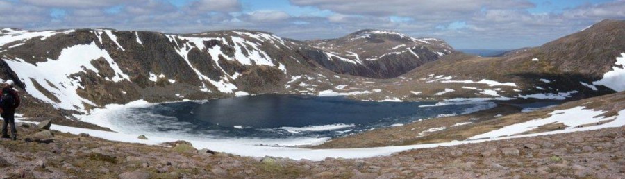
Despite the poor weather and shipping forecasts, the 1.5hr sea crossing over to Rum on the ferry MV Loch Nevis was relatively calm. Hot drinks, snacks and bacon rolls from the ship’s cafeteria were most welcome. The cloud level was variable with the Sleat peninsula mostly covered. But luckily for us, all of the Rum Cuillins could be seen apart from the highest top of Askival when coming into dock at the pier of Loch Scresort.
There are not any tarmac roads on Rum, but it was only a ten minute walk on a good surfaced track from the pier to our accommodation, this being the community owned bunkhouse.
On arrival we were met by the temporary warden, an extremely nice lady by the name of Bernie. After a short wait while she and the team made the bunkhouse ship shape for us (and it was), we were able to get in and settled.
Rum bunkhouse must be one of, if not the nicest hostels in Scotland. The accommodation comprises adequate toilet / showering facilities, one double room, three four bunk rooms, one six bunk room, two kitchens, large eating area and a view from the glass fronted sitting room out to Loch Scresort to die for.
As the weather forecast was pretty dire for the following days and Sunday wasn’t all that bad, six hardy walkers decided to head up onto the Cuillins to see if summiting a hill was going to be possible. It turned out to be a good call as they were able to climb Halival and the highest hill on the isle, the Corbett Askival. Other walkers from the group decided on the 16km round trip to the very picturesque Kilmory Bay.
The weather forecast for Monday was very poor with extremely high wind expected on the hill tops along with heavy, thundery rain showers. The distinct possibility of our return ferry being cancelled on Wednesday was going to be a problem for some of us, so six participants took the chance of returning to Mallaig on Monday afternoon. The rest of us were able to complete low level walks including a successful visit to the otter hide for one individual. An eagle was also spotted on a walk to the old settlement of Port na Caranean. Tuesday's weather was slightly better, but still not good enough to venture onto the Cuillin Ridge. Undeterred, our remaining group donned waterproofs and set out onto the lower hills and were able to have a very enjoyable, windswept and sometimes wet day out. Hills completed on Tuesday were Orval, Fionchra and Ard Nev. The party split up with some visiting the Harris settlement on the south western side of the isle to view the Mausoleum there.
Very high winds were once again forecast for Wednesday our departure day with some locals thinking that the ferry wouldn’t be sailing. The Calmac website and mobile app were showing disruption for our trip to Canna and back to Mallaig but would issue an update at 08:30 0n Wednesday morning. If the sailing didn’t go ahead, then the next day to get off the island would be Friday, meaning another two night stay.
But Calmac didn’t let us down. Notification came through as promised around 08:30 saying that the sailing was going ahead, but not the trip to Canna. We were all expecting a very rough crossing back to Mallaig, but to be honest, it wasn’t all that bad.
Safely back onshore this concluded a very enjoyable “adventure” to a very unique, special and different Isle. Has Rum been ticked off our to-do list? Definitely not! The Rum Cuillin Ridge is still waiting for a pair of CHC boots to complete its full traverse.
4TH AUGUST 2024
Poster
Angel's Peak, Sgor Mor/Sgor Dubh
Photos
Long walk: Angels Peak by the Northeast Ridge
Four club members enlisted on this adventurous walk, two biking from Linn of Dee to Derry Lodge and two walking. The rendezvous at the Lodge was grossly uncomfortable due to the midges, but by the scheduled 08:20am departure all four set off walking the standard route to the Lairig Ghru.
The weather forecast for the day was not encouraging with predicted cloudy and windy summits and some light rain especially in the late afternoon. We made good speed into the Lairig Ghru, with Corrour Bothy across the glen and though a tempting diversion, we forged ahead up the Lairig meeting a few walkers and overnight campers as they walked out.
We had to make a decision as to where to leave the comforts of the Lairig path and had westward int Garbh Corie choosing to contour around over fairly rough, terrain once the playground of a glacier. The Garbh Corie (refurbished 2018?) refuge was reached and there was sufficient headroom inside to sit down and have a good snack. When we finally emerged the weather had changed slightly with light rain in the increasing wind but undeterred we looked carefully for the best route up the lower part of the northeast. It was a grassy/gritty scramble between some slabs of granite on the left and small outcrops on our right but at times a route forged by others before us, could be followed. Surprisingly quickly after 200 metres of ascent the beautifully teardrop shaped Lochain an Uaine into view through the mist with the surrounding peaks of Angels Peak and Cain Toul shrouded in cloud.
Onward was up the main ridge for 300 metres of ascent, a real rocky scrambly rich taking us above the cloud base. It was just a question finding the best scrambling route amongst the rocks and boulders or following intermittent signs on the ground where people had gone before. Finally, the ridge stopped at the cairn on the summit of Angels Peak. Here we have lost the shelter from the wind that we had enjoyed on the ridge and it was not a place to hang around.
We had decided not to ascend Cairn Toul (hree of us had already done that two weeks previous) so we skirted by and eventually reached the bealach with the path down Corrour Both and the path up to Devil’s. The bealach was a bit windy with fragmentsed cloud blowing over, so we split with two going down and two going up Devils Point, a 1.5 km, 35 minute diversion. As we ascended the hill the cloud base lifted a cloud free top with spectacular views down to Glen Dee/Lairig Ghru and Glenn Geusachan with their meandering river courses and oxbow lakes.
We regrouped at Corrour Bothy for a final refreshment before the long haul back to Derry Lodge It was still a midge-fest where the two bikers picked up their steeds and sped away and the walkers put in another 5 kilometres (the last 1km the rains came on) to the car (and more midges) at Linn of Dee. Here everything was thrown into the car and a speedy exit made, boots being taken off in the more hospitable environs of Braemar.
Total distance was 39km return from Linn of Dee including Devils Point, just under 1500 metres vertical ascent and 12 hours of walking - a tough day out.
Short Walk Report – Sgor Mor and Sgor Dubh
Our group of 5 met at the Linn of Dee car park (NO 063897) at 09:00am. The weather at the start was mild and cloudy with light winds in the valley. We set off at 09:10 to tackle the route in a clockwise direction, taking the track W to the White Bridge then headed NW on a path, stopping for a break at the pleasant water falls at Chest of Dee.
After the break, we continued along the path to a burn crossing at NO 003896, then headed NE uphill across open ground to the summit of Sgor Mor (813m). We stopped for a break in the shelter of the summit cairn as the wind had increased and it felt quite cold. Sgor Mor was briefly covered in cloud but once it cleared, we had good views to the north into the Cairngorms although the Munro summits were in cloud.
We continued E along the ridge on easy terrain and spotted a herd of deer on the skyline to the south. After crossing the 744m top, we continued to the summit of Sgor Dubh (741m) There were a couple of light rain showers but once the cloud had cleared, we had fine views of Glen Lui. We descended the shoulder SE from Sgor Dubh over open moorland. As the ground levelled out, we headed S and intercepted a deer fence and a rough path that we followed until we reached a gate in woodland above the River Dee. From there it was a short descent on a feint path to the main track and we returned to the car park at 1530.
This was a fine hill and ridge walk covering 17.0 km, 574m of ascent and a time of 6 hrs 20 mins, including breaks. With enough time in hand, we stopped for refreshments at the Bothy in Braemar before heading home. A great day out and many thanks to the drivers.
Saunter: Carnferg from the east-ish
Photos
We gathered on the Aboyne Bridge encouraged by a forecast of a dry, breezy day with a sunny interval or two and surveyed the sorry state of the 86 year old bridge closed to traffic since November 2023 and not expected to be repaired before 2026. No problem for the hillwalker but an irritation for those dwelling on south Deeside soon to be exacerbated by the placing of one-way traffic on the 89 year old Dinnet Bridge.
Nine saunterers enjoyed the short traffic free zone before a short stretch of the south Deeside road took us to our turning into the woods and shortly to the delightful view of Birsemore Loch overlooked by a log cabin said to have been built by King George V for Queen Mary. As we passed by the log burner was being stoked the smell of woodsmoke rather incongruent with the warm weather we were enjoying. This makes the first part of the walk very scenic as the path stays close to the shore winding its way through well-spaced trees until a fence has to be negotiated to attain the track. No need for Catherine’s pipe insulation here as there is no barbed wire to worry about and only two strands of old wire remaining.
Still on low ground the dilapidated cottage of Parkside is passed, clearly the estate is happy for it to pass into a ruin in due course but for now it adds interest sitting at the edge of a field cut for hay surrounded by lush vegetation and close enough to hear the Alt Dinnie rushing past. The Saunterers took their time on the narrow path with the bracken closing in before the way rises sharply through the plantation of pines that was their outlook for the next 3 kilometres or so. Sunny glades on the way supported health blaeberry bushes bearing luscious ripe, purple berries and fingers were soon stained with the foraging. If we’d had longer enough might have been picked to make a pot or two of jam or jelly but we needed to be on our way now on a more or less level path.
The heat of the sun was felt in a clearing before the woods swallowed us up again following a less distinct path, so indistinct it wasn’t shown on any scale of map but a recce had proved it went where we wanted to go. Here and there the heather and tall bracken closing in on the path coupled with the leader’s inattention to his responsibilities led us astray and in due course it became obvious that we were not where we should have been. Were we lost? Thanks to technology we knew exactly where we were in the forest but not exactly where the path would take us. Should we go back? But that was uphill. Should we have lunch? It was a bit early. Should we head off the path towards the main track? But the going there was more difficult. Were we safe where we were? Definitely. In the midst of the debate Julie produced her emergency rations, a pungent, minty confection and thus fortified we made our way down through some timeless scenery to the track leading up from Newmill. As T. S. Eliot said, “We shall not cease from exploration, and the end of all our exploring will be to arrive where we started and know the place for the first time.” Now it was time for lunch; my navigational fumbling had taken us about a kilometre out of our way and wasted quite a lot of ascent.
After lunch with the reascent needed, the time and distance remaining to the summit the true Saunterers, five in number decided that it wasn’t necessary to go to the top of the hill to have a good walk and made their way down to the Fungle path. Staying on the established, west side of the burn a massive clearance of trees reveals how close to the edge of the steeply sided glen the track is and opens out long hidden views over to Aboyne. Those remaining took the path to the top of the hill passing a magnificently conspicuous clump of white heather, so unusual surrounded by its purple brethren.
The summit is adorned with a thin pyramidal monument to Joseph Robert Heaven who was born in Mexico to a Mexican mother, his father Robert a diplomat. Joseph married into Mexican nobility had business interests there and later in life became the proprietor of Forest of Birse living in Birse Lodge until his death in 1911.
The descent, on another indistinct path avoided the unpleasant eroded main track and cut off some of the distance to the Fungle path, here as we passed through the blooming heather the passage of our boots caused the pollen to rise as dust reminding me of the passage of the year. We were soon back on the way home turning off at The Guard on a well restored path to avoid the forestry activities and uneventfully down and back to Aboyne.
26TH-29TH JULY 2024 Fort William Weekend
Photos
Fifteen club members made it across to Fort William for the Club weekend. Twelve of us stayed at the Moorings Hotel, Banavie which is situated on Neptune’s staircase at the end of the Caledonian Canal and three stayed at the Glen Nevis Campsite.
The hotel proved to be ideally located with the bonus of being able to walk up and down the canal watching the boats negotiating their way through the locks. The hotel also had tasty food, nice rooms and friendly staff. Early breakfast no problem, late dinner no problem. It could definitely be a repeat location for the club.
The best bit of the weekend though was the great if not near perfect weather. This led to a lot of long hillwalks being successfully completed including a good number of target Munros as can be seen from the list below.
Munros
Binnein Beag
Sgurr Eilde Mor
Stob Coire Sgriodain and Chno Dearg
Stob a Choire Mheadhoin and Stob Coire Easain
Stob Choire Claurigh, Stob Coire an Laoigh and Sgurr Choinnich Mor
Aonach Mor and Aonach Beag
Carn Mor Dearg
CMD Arete and Ben Nevis
Meall na Teanga and Sron a Choire Ghairbh
Bidean nam Bian and Stob Coire Sgreamhach
Ben More and Stob Binnean
Cairngorm
Other Hills
Carn an Fhreiceadain
Sgurr na h Eanchainne
Meall an t-Slamain
The fine weather resulted in lots of photos that can be viewed on SmugMug.
17TH-19TH JULY 2024 Deeside Glenmore Circular
Photos
7TH JULY 2024 Carn Bhac, Carn Liath
Poster
Photos
Long Walk- Carn Bhac, Glen Ey
As a change from the quick route, and because I love it, we tackled this Munro from Glen Ey. This is such a beautiful glen, with a wonderful flat grassy base, bordered by steep hills on either side, but sadly depopulated in the 19th century, and now the most visible remain is the old shooting lodge at Altanour.
From here, the old shooting track took us westwards up to the summit and its white stones, so like An Socach but with helpful grass too. The view of the Cairngorms is breathtaking, and includes a wide sweep of Munros on all sides, including Beinn a Ghlo.
The offpath descent to Top of the Battery was easily handled, and, as usual here, we had a view below of a huge herd of red deer, the ones that are blamed for peat erosion and the lack of trees…
Swooping off the Top and saying farewell to its amazing landslip, we then found someone had removed the planks from the bridge at the bottom - but the burn was low and we hopped across without too much alarm.
I suspect I say this every time, but a huge thank you to the drivers, and to all 12 walkers for their stimulating company!
Short Walk and Saunter - Carn na Moine and Carn Liath
The combined short walk and saunter comprising a group of nine walkers and Mark’s dog set out from the car park from Inverey, walking initially along the road before joining the track up the hillside through the forest. After climbing through the forest, it was out onto the open moorland towards the first summit of Carn na Moine (755m) with its two cairns, neither of which seems to be at the highest point. We had magnificent views of the Cairngorm Munros on one side and Beinn a’ Ghlo on the other and some were able to name a number of the distant hills. From there we continued along the ridge track to the top of Carn Liath (818m) and stopped for lunch. From the summit we were treated to a short extension to see a grave! Not just any old grave, but that of Sergeant Arthur Davies. This was courtesy of Graham who had done his research about the history and found the location of grave situated just off the track from Carn Liath heading towards Carn Bhac. See below the facts surrounding the fate of the unfortunate Sergeant Davies provided by Graham.
In the aftermath of the 1745 Jacobite Rebellion Braemar Castle was leased by the government in 1748 to station Redcoat troops in upper Deeside. Sergeant Arthur Davies was posted to Braemar in June 1749 with a corporal and twelve men based at the farm of Dubrach on the south side of the River Dee just below the confluence of the Dee with the Geldie Burn where there are still some ruins to be seen.
On 28th September 1749 Davies was reported missing and a search failed to find any sign of him. He had been on a routine patrol to the head of Glen Ey to meet his equivalent military contact from Spital of Glenshee and would have returned by Carn Bhac and Carn Liath. In 1750 a hat was found which proved to belong to Davies. Subsequently, the remains of a body were discovered at the head of the Allt Cristie Beag, around 2,500 feet above sea level.
The body had been dismembered by birds of prey and the remains were buried at the site. Late in 1753 two men were arrested for the murder and tried in Edinburgh in 1754 but based on mostly circumstantial evidence they were found not guilty. While they might be suspected as the murderers, the case remains unsolved.
On the visit the grid reference showed NO 034 861. The grave is marked by a slabby stone about a foot high on a slight mound.
For anyone interested a fuller account is given by Fenton Wyness in his book Royal Valley Chapter 36.
From the grave we descended to join the main track that follows the Allt Cristie Beag down to the road. It was fine day for walking, enabling us to forget about the recent general election and enjoy the beauty of the hills as well as each other’s company.
24TH JUNE 2024 Carn Aosda and An Socach
Photos
A 3 Munro round from Baddoch, in Glen Clunie, this was a fairly lengthy walk (for some of us!) of 21km, and a reasonably hefty ascent of 1180m, but this was countered by some good varied underfoot conditions.
Carn Aosda is graced by stunning wildflowers, some extremely friendly Highland ponies and at least 6 graceful mountain hares. A beautiful ascent from the north. Ok, less appealing is the ski infrastructure on the other side – but for how much longer will this be at all viable?
The path across to Carn a’ Gheoidh is very pleasant, a path and not a track, and is also adorned at one particular spot with unusual wildflowers. It’s an easy ascent, and the descent to the Baddoch burn was also surprisingly easy underfoot, the burn itself in low water, and the climb up An Socach at a good gradient.
Of course, the An Socach plateau is a sea of broken rock, after the first kilometre, you begin to long for soft grass, but the descent back to the Baddoch burn gave us a view of a ptarmigan family, parents and chicks hurriedly hiding among the many stones.
A great day out! Thank you drivers Geoff and June, and to all 12 walkers for their company.
6TH-9TH JUNE 2024 Arrochar weekend
Photos
2ND JUNE 2024 An Sgorsach & Carn an Fhidhlair, Morrone, and Forest of Birse Saunter
Poster
Photos
Long Walk- Carn An Fhidleir and An Sgarsoch
4 of us met at Linn of Dee armed with bicycles. An advance party of 2 had already gone ahead anticipating their slower pace on the bike leg. An easy but very windy ride out to the relatively recently renovated Red House Bothy where an inspection of the policies revealed 8 bunks, 1 guitar (only 5 strings) and a series of toilets designed for group participation.
The wind remained stiffly against us on the bike out to Geldie Lodge so one brave rider decided that their energy reserves would best be conserved for the ride back and so turned around for a nice wind assisted run back.
The 3 remaining walkers forded the Geldie Burn and set off on foot to conquer Carn An Fhidleir. The good track and path eventually fizzled out and the heather was bashed to the top. The wind became stronger at higher altitude and so the summit stop was brief. Down and up again to summit #2 An Sgarsoch with further cross country skills being called upon. Then downhill to rejoin the outward track where we caught up with the advance party taking a short rest. Back to the bikes and a whizz home to Linn of Dee. Wildlife of note for the day: lapwings and plovers. Plus about a dozen bicycles in 3 or 4 groups at Geldie Lodge, although we never saw their riders all day long. Weather threatened rain later in the day but it never came to anything.
Short Walk- Morrone Corriemulzie Circuit
Our group of 7 met at the Braemar Duck Pond car park (NO 143911) at 09:50am. The weather at the start was mild and clear and a moderate westerly breeze. We set off at 10:00am to tackle the route in a clockwise direction, taking the path to the viewpoint by the settlement of Tomintoul then up the path to the summit of Morrone (859m). We stopped for a short break and had fine views across the Cairngorms with Ben Avon, Beinn a Bhuird, Derry Cairngorm and Ben Macdui clearly visible.
The wind had picked up as we continued down the vehicle track to the bend at NO 131875, then SE on a path across a col and up a gentle rise along the ridge. The ground became flat and we picked up the ridge path and headed SW to Carn na Drochaide (830m) then W into a fresh breeze to the top at the end of the ridge (NO115861, where we good view of the route down to the Corriemulzie Burn to the north.
We headed due N downhill off path and had another break on sheltered ground part way down. There was no sign of the line grouse butts featured on the OS 1:25,000 map and presume they had been removed. The route continued downhill off path over rough ground and joined a grassy track to the west of the shallow ford near the confluence with the Corriemulzie Burn. We followed the track along the Corriemulzie Burn, spotting a small heard of deer on the hillside and stopped briefly to chat with an instructor of an outdoor activity site operated for guests at the Fyfe Arms Hotel. He was preparing equipment for archery, clay pigeon shooting and axe throwing! He mentioned there had been a sighting of a Golder Eagle earlier but not for us!
We continued, keeping our heads down and paused at the Braemar Community mini hydro scheme by an attractive waterfall then into the woods. Our route continued to the disused dam above Linn of Corriemulzie then NE through forest plantation to a layby off the Linn of Dee road. We then headed back into the plantation and then into the attractive Morrone Birkwood with open birch and juniper woodland before returning to the car park around 4:15pm. Some of us stopped off for refreshments at the Bothy in Braemar before heading home and many thanks to the drivers.
This was a fine hill and ridge walk covering 16.2 km, 725 m of ascent and a time of 6 hrs 15 mins, including breaks.
Saunter - Forest of Birse
There’s Hidden Aberdeenshire, Secret Aberdeenshire and then there’s Glencat, a wee glen tucked away in the lee of Carnferg maybe only known to the girls and boys of Ballogie as there’s no sign post at the road junction but then apparent remoteness and tranquillity aren’t signposted; they have to be searched out and enjoyed for what they are and that’s just what the Saunters did on this sunny Sunday.
Worries that the small car park at the end of the road in Forest of Birse would be full that caused an earlier start did not materialise and didn’t discourage the 14 Saunterers who took to the road for about a kilometre before turning off the tarmac and following the grassy track that rises gently out of the glen. Here the heathery moor is studded with regenerated Scots pine all doing very well in the certain absence of sheep and the apparent lack of deer. Elsewhere in the glen, looking around once we’d gained some height, that’s tens of metres not hundreds, this was a Saunter after all, the early summer freshness became apparent with the brilliant green of young bracken and blaeberry contrasting sharply with the dun coloured heather on the hillside opposite.
The track, deep set in the heather meanders on and rises near the summit of Corybeg at 376m high enough to merit a coffee stop and the beginnings of a fresh view across the Dee north to the hills above Aboyne. There was Mortlich, a destination worthy of any walker and the curiously named Scar Hill walked in the time of Covid restrictions and again as an appetiser to a Club Christmas lunch outing. Our way was down past a solitary fallen pine tree long since the victim of a winter storm that had toppled across the path and not cleared away showing how infrequently the track is used. Further on our rutted track through the denser commercial forest changed suddenly into a highway that looked as it’s going to be put to a lot of use soon. The earthwork was as fresh as if it had been bulldozed last Friday and a bit further on in a freshly bulldozed layby was a bulldozer. We passed by carefully as it was a bit like meeting an elephant in the jungle.
Farm buildings came into view, this was Murley an enterprise now given over to equitation, so the sign says at the end of the road as there were no runners or riders out on Sunday that we noticed. On the way past the cutest country cabin sits in a clearing next the track, it looks well maintained, has a lovely south facing porch, two or three rooms and a stovepipe emerges from the gable end but it has that sad unused look about it that shows those who loved it had moved on.
We’d arrived in Glencat in a glade of birch trees and dappled shade, the pine trees having been left behind here the track followed the Burn of Cattie on past a sign clearly designed to discourage walkers saying “Beware of the bull”. The hindquarters of a large animal were spotted in an adjacent field but given the horsey activities on the farm it was more likely to be a Clydesdale, a gentle, friendly beast and nothing to worry about.
Hereabouts the Burn of Cattie had to be crossed, the poster had mentioned “stepping stones” but to get there we had to step off the path that had been a very comfortable wander past cultivated fields with the burn gurgling along into the long grass and over a hillock studded with emerging bracken so there was a feeling of some apprehension in the midst. Perhaps they had heard what happened the last time Saunterers got close to a stream.
It was an awkward step down and the stepping stones were just underwater that looked deep and it was flowing fairly fast but we all managed to attain the far bank safely (one of us with a helpful push from behind – Ed) and make our way alongside a meadow covered in the yellow of buttercups before having to negotiate a very boggy bit before a halt was called to the undertaking and we had lunch just above a lochan that looked artificial but now seemed now to have no useful purpose apart from supporting a health dragonfly population.
After lunch we regained a track through mature pine trees and onto the road that leads to Glencat farm, an area of fine grassland with cattle grazing and on the higher fields a large flock of sheep were keeping the grass trim. Most of the sheep were well away from us but next to the track was a ewe struggling as if trapped, tangled up in a fence or some loose wire. She was stuck, well and truly trapped as a large branch had somehow got entangled in the curve of her right horn as she grazed. What secured her to the spot was that the other end of the branch was entangled in the fence that bordered the path. We couldn’t pass by and do nothing for this distressed sheep, nobody else was about so various attempts were made to wrestle the ewe free but without success. We’d just passed the farm house and the farmer was summoned (after a collective decision that if anything should go wrong it shouldn’t be at our hands – Ed) whose strength and experience of animal handling freed the terrified animal after quite a struggle. The farmer thanked us but the sheep, it just ran off to join the others.
Our uphill way lay ahead, the track going over the shoulder of Brackenstake with views across to the monument identifying Carnferg. It was a steep pull up in places to the crest of the pass with shooting butts going up to the skyline. Downhill, back into Forest of Birse had some steep, loose gravelly sections where care was needed and a burn to cross, much easier that the Burn of Cattie. The final stretch of the way was an avenue of mountain ash all decked with flowers just before the clearance that was the car park.
20TH MAY 2024 Inverkeilor to Arbroath
Photos
Sometimes you just get lucky ... glorious sunshine all day and a wonderfully cooling onshore breeze made for perfect weather conditions for this coastal walk.
The 13 of us took to the quiet tracks to the sea then the field margin paths (ignoring the coastal path sign pointing firmly inland) which alternated with some cliff top paths (hardly nerve-wracking at all) for the section to Auchmithie. Highlights: the cliffs at Red Head, and the flock of apparently feral sheep and lambs, some looking convincing goat-like, romping along on the steep hillsides above the sea.
From Auchmithie south, there is a made path to Arbroath, with geological points of interest marked by posts. There are indeed some stunning formations , although the best of all is now completely fenced off, and there is online a copy of the leaflet that describes them - “Arbroath Geodiversity Trail”.
And there were seabirds, not in huge numbers, but we saw eider, cormorants, fulmars, kittiwakes, guillemots and (I must include this!) house martins. Plus many wonderful wildflowers clinging to the precipitous cliffs.
Thanks, as always, to the drivers Nick, Malcolm and June, and to the passengers for their patience while we moved cars around.
3RD-6TH MAY 2024 Inchnadamph weekend
Photos
27TH APRIL 2024 Mount Keen
Poster
Photos
The May Sunday Walks were moved to Saturday 27th April to avoid a clash with the Club Weekend at Inchnadamph.
Six of us met the bus bright and early in Culter for the Sunday May Long Walk including Sandra who a had kindly stepped in at short notice to lead the walk. We then set off for Bridge of Muick and the start of our walk. The weather was set fair for a change with the prediction of a possible shower around midday. Alighting at Bridge of Muick we helped the bus turn around to go back to Culter to pick up the walkers for the Short Walk up Mount Keen from Glen Esk and return.
The walk started up the track towards Craig Vallich where we briefly stopped sheltered partly from the wind for a quick coffee stop. Descending to the finger post encouragingly saying Mount Keen we followed a faint footpath over a col between Garbh Choire and Knockie Branar and down to the main path up Glen Tanar where after passing some old sheilings, we crossed the bridge over the river and picked up the Mounth Road to go to the top of Mount Keen. This is where we encountered a brief shower, the sort that stops just as you have finally decided to put on your waterproofs. We pressed on up the rubbly track which soon changed to a very well built footpath that took us all the way up to the top of Mount Keen. By this time the morning mist had cleared from the top and we were enjoying panoramic views westwards across to the Cairngorms dressed in a new covering of snow, north to the Buck of Cabrach and north east to Bennachie. After a stop for selfies at the cairn, we huddled down for lunch sheltering from the keen south wind.
After lunch we set off down the track south to Queens Well looking out for the Culter club members doing the Short Walk. As they had not manged to start until 1120h they were further down the track that we expected but making good progress. After a brief catch-up we continued down to the Queens Well, which didn’t look too inviting to drink from despite the plaque stating that Queen Victoria had done so when she had visited.
We continued along the glen emerging at the carpark in Glen Esk at Auchronie in sunshine where the bus was waiting for the short walkers. As we passed the bus driver called out that he had a flat tyre but he had managed to call out a tyre repair man who was on his way. This slightly jarred our buoyant mood but finalised our decision to include going up the Hill of Rowan on our way to Tarfside. Now the walk was all sunshine, newly born lambs, lapwings, larks, curlew and grassy paths. We stopped at the top of Hill of Rowan and contemplated the large Maule monument on top built by the first Baron Panmure in 1866 to commemorate seven members of his family. Here we had another leisurely stop. Then on to Tarfside stopping briefly to admire St Drogstan’s carved cross stone. We arrived at the Tarfside carpark feeling impressed with ourselves having walked 26.8 km with 1142m ascent. Encouragingly a tyre repair van was spotted going up the glen as we approached the carpark.
Now we set out to wait for the bus. Fortunately, it was still sunny but the lack of mobile signal meant we did not know whether the short walkers had returned to the bus or if the bus tyre had been repaired. Eventually Peter from the Short Walk group hitched down the glen to tell us that his group was back at the bus and the tyre repair was progressing. Casting about for a place where we could obtain some sort of mobile signal, Sandra found a raised verge which gave a patchy enough signal to tell the respective partners that we were going to be late home. At this point John who was leading the Short Walk called to tell us that tyre jack had collapsed leaving the bus on its back axle. There was talk of a bus being diverted on its way back from Dundee up Tarfside to pick us up but it was one space short and it hadn’t yet left Dundee. The Short Walk members at this stage managed to hitch lifts down the glen to Edzell with other hillwalkers but as there were no other cars coming down the glen we were stuck with a long wait and starting to get cold. Our previous jokes about using our emergency shelters were now becoming more serious. Then the kind residents of Tarfside came to our rescue with two of them ferrying us down the glen to Edzell to meet the others who back in the land of mobile signal had managed to phone respective family members to pick them up. Just as we entered Edzell we met the diverted football team and supporters bus as well. In the end 3 walkers travelled with the disgruntled football supporters on their bus and the rest of us made it back in cars.
Thanks to Sandra for leading the Long Walk at short notice, John Adams for coordinating the day including the eventful end, the residents of Tarfside and the hillwalkers who gave us lifts to Edzell and all the car drivers who came down to Edzell to collect us.
Short Walk Report – Mount Keen from Glen Esk
The group of six on the short walk joined the coach mid-morning in Culter on its return from Ballater and set off for Glen Esk arriving shortly after 11:00 – all very civilized. The weather was cloudy but dry as we set off for the easy walk up Glen Mark, with lots of chat on the way. So much chat that some of the group bypassed the Queen’s Well and were far ahead when it was time for a break. Having regrouped we found a suitable point for a stop by the Ladder Burn. Immediately confusion set in. Was this a coffee break or was it lunch? The late start was now playing havoc with our normal routine. The consensus was first lunch and provisions were consumed accordingly.
Then the real work of the day began with the long ascent towards Mount Keen. A ring ouzel teased us with a song as we set off but it was never spotted. After a steady climb the gradient eased at last and to our surprise the long walk group came into view approaching us (we were impressed by their progress). We exchanged news – mostly about the weather as they were wrapped up against the chilly conditions on the top. A surprising distance remained before we reached the trig point on Mount Keen. To demonstrate our hardiness, we decided to have second lunch on the top – a stone shelter giving good protection from the wind.
After admiring the extensive views to Ben Avon, Lochnagar and Glen Tanar we started to retrace our steps. The descent was very pleasant as the clouds dispersed and the warm spring sun came out. A good pace was set with the only a brief photo stop at the Queen’s Well delaying the walk to the car park. So far, it had been a very enjoyable outing in good company and with better than expected weather (18km, 720m ascent in 6 hrs 20 mins).
However, that’s not the end of the story, the real adventure of the day was only just beginning. This is a lengthy saga and you may want to stop reading at this point….
Note that what follows is only one version of what happened as our experiences and recollections may vary.
Approaching the bus, we met our driver, Ray, coming towards us with a troubled look. He reported an issue with the vehicle and explained he was heading up the glen to get phone reception to arrange help. The severity of the problem was soon clear – the coach was sitting at an unusual angle. The tyre mechanic, Lewis, explained that during replacement of a punctured tyre the jack had given way, the axle stand had jumped out and the coach had fallen on its chassis. Fortunately, no one was injured.
What to do? No phone reception. The long walkers ending at Tarfside didn’t know of the situation. We weren’t allowed to board the coach. The locker underneath with our gear couldn’t be accessed (it needed a key in the ignition) and the warm afternoon was now turning chilly.
Other walkers were returning to their cars and a lift was arranged to take Peter to Tarfside to let the long walkers know what had happened. We watched other walkers return to their cars but as our belongings were locked in the coach (including for some their car keys) we were reluctant to leave.
We waited for our bus driver to return with some news, but time ticked by. Questioning some returning walkers they reported seeing a man in a hi-viz jacket outside a house holding his phone. John set off to find him. Ray the bus driver was some way off, by now cold and waiting by the gate to a house. He had been given a wifi password by the woman of the house earlier in the day in order to call the tyre company. Now he was waiting for a call back from his office with an update on rescue plans. He was just within wifi range of the house – just as close as a beady eyed peacock in the garden would allow.
Finding a replacement driver at 6pm on a Saturday evening was proving difficult. Occasional snippets came through – including the possibility of other coach companies from Brechin or Forfar. Then a definite plan emerged – a football coach from Dundee to Bridge of Don would meet us at Tarfside. Just one issue, only 11 seats available for our group of 12. Nonetheless it was the best available option. We managed to contact Sandra at Tarfside, who somehow had signal, and let her know the plan.
Ray stayed with the peacock to await news of his own rescue which would require a breakdown truck with a big enough crane to lift the bus. Returning to the stricken coach, John found the car park deserted. No walkers. Lewis, the tyre guy, said that our group had managed to arrange a lift to the pub in Edzell(!) As he could do no more on site he wanted to head back to base. Aberdeen it turned out, and he was willing to take a passenger and our gear. The bus driver returned with his keys and we opened the locker and transferred all the belongings from the bus to the van and set off down the glen.
When we arrived at Tarfside it was deserted. No walkers. No cars. Nothing. Another group lost, what a puzzle! John searched the area to see if the group had found shelter nearby. Meanwhile Lewis called his boss and among other things was told that under no circumstances could he provide a lift to anyone!
Abandoned in Tarfside. Just then two cars pulled into the car park – the long walkers, being transported by helpful Tarfside residents, had just been up to the bus to look for their belongings. Fortunately, there was space for one more passenger. Somehow all the rucksacks and spare bags for our twelve walkers were fitted in. We set off in cramped conditions for Edzell, hearing about life in Tarfside along the way.
Sue’s husband had been contacted and was on his way (now redirected to Edzell). All we had to do now was intercept the rescue coach that was heading for Tarfside. We met the coach near the start of the Glen Esk road and had another hasty transfer of bags to the coach. Four of the group then joined the Dyce Juniors football team and their supporters on the rescue coach. The atmosphere on board was a heady mix of testosterone and Tennants lager with the passengers not appreciating the diversion to Glen Esk. (They must have lost their match).
The request to stop at the Panmure Arms was begrudgingly tolerated but when nobody boarded the bus, the delay appeared pointless to the footballers (the recovery of bags from under the bus wasn’t noticed). By now, more friends and family had been tasked to drive to Edzell, leaving only three of us to enjoy the footballers coach.
Once on the A90 the mood lightened. Going via Culter was dismissed out of hand. Stops were Cove, Market Street and Bridge of Don. Our plan was to get out at Market Street and then pick up a lift/taxi from there. However, we heard that the Market Street stop was abandoned. A request for a brief stop anywhere in town to let us off was abruptly rejected by the team manager! Getting off at Cove seemed the sensible option at this stage. Another family member was called upon to meet us at Cove. All went well from that point.
A big thanks to the friends/family members who set off to rescue us. Thanks also to the unknown walkers in Glen Esk and the Tarfside residents who played their part in getting us home. The kindness of these strangers gave an uplifting end to an eventful day. Only those who missed the pub stop felt hard done by!
Ray our bus driver had to wait until just before 10:00pm for the recovery truck to arrive and only reached Aberdeen at midnight.
PS A few days later Nick kindly visited Glen Esk to deliver some gifts to the two Tarfside residents who so generously helped us.
15TH APRIL 2024 Cnap Chaochan Aitinn
Photos
7TH APRIL 2024 Glen Tanar & Prince's Stone Saunter
Poster
Photos
Long Walk Report: Glen Tanar Circular from Dinnet
The published April Long Walk to Duchray Hill was cancelled at short notice due to exposure to the severe SSW winds (45 – 65 mph) from Storm Kathleen and a high risk of swollen streams along the route. An alternative route in the less exposed Glen Tanar Estate was chosen instead.
Our group of 7 met at the parking space on the B9158 (NO 461984), next to the bridge over the River Dee at Dinnet on Sunday 7th April 2024. The weather was windy (20 - 40 mph) with rain showers and bright sunny intervals.
The group set off at 09:30 hrs, over the River Dee bridge to the T junction with the B976 and crossed to a path heading SE through mixed woodland. Then we joined an estate track passing the farm buildings at Tillycairn and noted a couple of inscribed stones, including one marking the point crossed by the invading armies of King Edward 1 in 1296 and 1303 and the army of Montrose in 1645! We saw some deer and a brown hare in one of the fields before continuing to a gap below Belrorie Hill and joining a path downhill to the stone arched bridge and the Visitor Centre.
We stopped at the Visitor Centre and had a quick chat with the rangers about our proposed route then continued past the kirk to the Fairy Loch before taking the next track due S and uphill across open ground into woodland. Here we stopped in relative shelter for a refreshment break and continued uphill on a vehicle track that diverged from the marked track on OS map. We eventually joined the main track heading S below Black Craig and onto the col below Baudy Meg.
The group then headed W in the shelter of Baudy Meg and paused to take in the fine view across Deeside with Morven, The Buck and Loch Kinnord clearly visible. The showery weather presented us with a superb double rainbow as a reward for our efforts! Our route then descended N through conifer plantation to the viewpoint overlooking Glen Tanar House then SW along the valley of the Water of Tanar on good track. We passed a well with an engraved stone dated 1869 attributed to the landowner Sir William Cunliffe Brooks, then on to a stone bridge over the Water of Allachy where we took our second refreshment break.
After crossing the bridge over Water of Tanar, the route headed E along the main track then N up a steep track around the head of the Burn of Boonie. We continued through forest plantation to the track crossing the col between Creag na Slice and Slain a Gour then down into the River Dee valley at the abandoned buildings at Little Tulloch.
The final stage of the route headed NE through farmland and onto a muddy farm track past Netherton and onto a short woodland path, returning to the main road and back to the car park at 16:00 hrs. A great day out, making the best of the weather conditions and covered 23kms in 6 ½ hours with 660m total ascent.
Saunter: The Prince’s Stone
This was a very eventful Saunter to a point on the map that if it hadn’t been for an overnight stay by Prince Albert in October 1857 and the inscription on a convenient boulder, not many walkers would consider the small grassy sward as a destination. For the more intrepid hill goers Lochnagar lies ahead while the summit of Cnapan Nathraichean is perched above the slabby cliffs that makes the setting of the Stone so spectacular.
Not so spectacular the Invercauld carpark on a damp and windy Sunday morning as the company assembled, waterproofs at the ready if not already worn, such was the menacing impression given by the clouds dashing across the tops. However, any rain proved to be fleeting and most of the moisture we experienced was underfoot starting with a very muddy track to the Old Bridge of Dee, the pale stone structure gleaming in a sunny interval as we came out of the trees to admire it. Built in 1753 by the military to link up the barracks and chain of roads pushed through the countryside to make it easier to control the country and its inhabitants. Up to this time and for another century it was only the second permanent bridge over the Dee, the first being the Old Bridge of Dee at Aberdeen.
Having crossed the river our route was gently uphill and past the junction with roads leading to the Honka Hut, the Garbh Alt falls and bridge and our way left, to follow the river over bridges across the Garbh Alt and the Alt Lochan nan Eun the latter carrying a huge volume of water, the burn that washed away the vital stepping stone on the path we’d intended to take. The track we walked was the original Deeside road, and when it was taken into the Balmoral estate Queen Victoria had the road we now drive on built to ensure her privacy. The Dee bridge at Invercauld paid for by Prince Albert dates from this time.
Forestry work and new fencing work was causing the road to form potholes so it was good to get off its surface and into the forest where the footpath works with the land to carry the walker enjoyably onward and upward until the east/west footpath is reached. The high point on this path gave us magnificent views over to Beinn A’ Bhuird and Ben Avon as well as the Dee and surrounding counrtyside and then down to the crossing of the Ballochbuie Burn, a convenient, sheltered place for lunch. Rested and refreshed we walked on out of the trees and onto the open hillside, the footpath here has been recently improved and going was easy for the time being. On our left was the impressive north east face of Cnapan Nathraichean, the steep crags wooded with Ballochbuie forest regeneration and a scattering of birch and willow.
The stiff breeze was beginning to make itself felt as we pushed through the glen but we were able to make good progress to the junction of the path that leads up to the Stone. Not very far along this new path our progress faltered and came to a halt as we surveyed the Feith an Laiogh burn we needed to cross if we were to achieve the day’s destination. It looked very deep and the water was rushing along fast enough to make a hydraulic engineer jealous and just too wide to cross with an easy leap. Luckily two energetic leapers (it is a leap year, after all) made the crossing and helped the others safely across. The path follows the burn steeply up and the valley narrows, the burn turns into a series of waterfalls, the wind gusts and Chris topples head first towards the foaming water, fortuitously her fall is arrested by a wiry willow bush into which her rucsac became entangled. Help is on hand immediately and Andrew, on his first outing with the Club drags her to safety. This could have been a very serious incident but Chris was none the worse, didn’t appear shocked or shaken up. We were all mightily relieved and almost as soon as she was on her feet was looking up the path as if looking for her next adventure.
Shortly thereafter we turned a corner and the soggy path led us to the Stone heavily covered in lichen making the deeply carved lettering difficult to read. The Prince had the advantage of a wooden shed to shelter in overnight and was probably accommodated and catered for in the regal manner to which he was accustomed. Looking round the view was much the same as it would have been 163 years ago, bar the snow, the gully ahead steepened and the view of Cac Carn Beag, Lochnagar’s highest point showed a snowy top both left well alone for another, calmer day.
Our descent thankfully was trouble free, the stream leapt without much in the way of hesitation and after steadying ourselves several times against the increasingly gusty wind made it safely down to the shelter of the Ballochbuie where we relaxed with the remains of our lunches. The path follows the line of the Ballochbuie Burn more or less straight down the hill resulting in a horrible network of slippery tree roots, slimy stones as all the finer gravel has been washed away, naturally the flatter areas have gathered all the water brought down and a very spongy bog results sending us off in all directions to attempt to find the least wet route back to the main road. Here we turned for home stopping at the bridges to ponder the forces that had brought the huge boulders down to rest in the rushing stream. Over the old bridge still standing as built ready for the next regiment to march over while its more modern neighbour limps along now only able to offer single file traffic.
In the car park Susie had read her book having decided that a short portion of the walk was enough on a windy day and was pleased to see us as we’d been away for 6 hours, longer than the usual duration for a Saunter. The walkers glad to be back, were all smiles after demanding day.
18TH MARCH 2024 Ballochbuie Purchase cairn
Photos
Sunshine! How wonderful! After days of murk & rain, to be out on Balmoral estate, admiring snowy Lochnagar while basking in the warm sun, was such a huge mood lifter.
The estate itself around the castle being closed until the weekend, we did have to use South Deeside Rd, but this was balanced by a lovely path up the side of a dry rocky mossy valley. The Glen Gelder track highlighted Lochnagar , then, passing Ripe Hill, we took a quiet little path that crosses over to Ballochbuie – the path now somewhat tarted up with cross drains, but I guess that’s progress…
The 12 strong group visited the 2 highpoints, Cnap a Choire Bhuidhe and Craig Doin, all pathless rough moor, with the best views, then the Purchase cairn itself, its plaque announcing the first act of conservation in Scotland – the saving of Ballochbuie Forest by Queen Victoria in 1878 – “the bonniest plaid in Scotland”.
A sweeping offpath descent through an old but airy pine forest brought sightings of deer, then the high traverse path showcasing the Dee valley and hills beyond. More deer, tame this time, for some, while others tackled the Allt Lochan nan Euan burn crossing – no longer recommended now that one of the huge stepping stones has been washed away.
A most enjoyable walk, with much thanks to the weather!
Thank you to the drivers Nick, Sue, June and John, coping most competently, as ever, with the swap arounds of an A-B walk.
3RD MARCH 2024 Dead Wife's Hillock & Ben Newe Saunter
Poster
Photos
Long Walk: Dead Wife’s Hillock & Scaut Hill
The threat of snow and rain vanished and we were left with a lovely day out in the remote hills of the Cabrach. Well, I say remote, but the 14 of us were accompanied by the view of the 59 wind turbines of the Dorenell Wind farm throughout the day. They are indeed elegant structures, and out here, where so few people walk, it did not seem so intrusive - there are anyway so many windfarms to be seen around the Cairngorms National Park, and especially as we can now sadly compare them to those destined for Hill of Fare at the double the height of these.
Our route passed an attractive little section of the Black Water, we appreciated the shelter of a plantation, Scaut Hill was a very tough offpath ascent but managed with (relative!) ease by the group, before heading down for some easy walking on the windfarm’s top quality tracks. Lunch in the sunshine at the abandoned Blackwater Lodge gave opportunities for exploring, before track took us up to the Dead Wife’s Hillock. The website Scotlands Places has this excerpt from 19th century Cabrach parish records: “It is said that during the famine in the end of the 17th Century, "the seven ill years," A woman was found dead there, who had perished of want, with a child alive sucking her breast, and that it had since retained this name.”
Now turning north, we had a few kilometres of boggy heather moor before visiting the Meikle Firbriggs trig and heading down the track to the start. Although our high point was a mere 607m, we tackled some quite tough ground in country far from our usual stamping grounds. Great views of difficult-to-name hills!
As always our grateful thanks to the drivers Nick, Sue, Sandra and Bill, additionally for being prepared to tackle potentially difficult driving conditions!
Saunter: Ben Newe
The day dawned bright and fair, with a promising band of bright blue sky to the west. The journey through Alford to upper Donside was uneventful and the quietude was only disturbed by our arrival at the parking area with the noise of car doors and the hailing of our fellow saunterers. Plenty of room thanks to the requirements of modern foresters and farmers who seem to need ever larger implements to carry out their work with fewer and fewer employees. On our walk we’d see the results of their labours and also much that remains to be done.
We turned our back on the main road and started up the track gradually climbing out of the valley of the Don on a series of zig zagging forestry roads well designed to make it easy to gain the altitude without working too hard with mature Scots pine on one side and Sitka spruce on the other, the former a much more open area letting the light in with the occasional sunbeam reflecting off their coppery trunks. Another advantage of the regular change in direction of the track was the changing view and we were soon looking out over the fields above Buchaam farm, a sizable complex of buildings but no signs of sheep in the fields or cattle in byres and unlike areas on Deeside no horses either.
The track steepened as we pressed forward feeling that we deserved a coffee stop; all this uphill a bit of a novelty for the Saunterers after last month’s coastal stroll and so it was that a halt was called at yet another bend in the road surrounded by forest. At this point in the walk the track disappears darkly into the forest well hidden by low growing branches, unpromising but thanks to the recce the Saunters had the confidence to plunge in, and shortly afterwards were absorbed into the half-light of a track that looked as if it had been forgotten, the floor of the forest carpeted in moss and long shed needles and the downhill trend made for a relaxing walk.
We emerged into the daylight after negotiating by the now obligatory fallen tree or three at the edge of the forest and onto a grassy path bounded by juniper with a view towards Glen Buchat and to the east though strathdon. We’d lost height in the forest and now the only way was up, straight up in indian file with some of the tribe wondering if we weren’t climbing the hill twice! But the going was good on the wet grass and after skirting more fallen forest a shoulder of Ben Newe was gained but as yet, no way up was obvious. Another descent, insignificant really, gave us good views of a snowy, cloud-capped Morven looking as cold as Erebus. Hereabouts the summit path sets of steeply at first and like the forest road twists to take the gradient easily before settling down to a short steady pull to the top. And what a fine top with all the accoutrements of many a higher hill; a fine craggy, pointy top with - yes - a trig point, benches built into the cairn and excellent views into Glen Buchat. We were all very pleased with our efforts but as there was a snell wind and lunch time was approaching we didn’t linger long, and headed downwards towards more clement conditions.
We hunkered down in a sheltered spot surrounded by toppled trees for lunch just off the track to be met by one of our number who had parked in an alternative car park and made his own way up, past us with a quick stop for a refreshment and on to the summit. We said we’ll see him later and so it proved.
The route after lunch was a grassy track over the shoulder of the Hill of Greenstile whose trees must have been clear felled some years ago and the ground replanted but unlike forested areas elsewhere here there are no deer or any other fences giving the hillside giving a lovely open feeling to the passer by. This, however is short lived as the track has been swallowed up by wall of mightily tangled wind-blown trees, making any planned progress here impossible. Not to worry as the recce had shown that the route down the edge of this disturbance led to another road that led to more zig zags that led down to the main road. Again, the prospect down to the fields with fine examples of bare beech trees standing clear of the scrub was a joy particularly as sunny intervals were becoming more frequent and the views out to Morven clear of cloud were outstanding as it seemed to be lit by cloud reflected sunshine. A surprise by the track was a sunny bank clothed with primroses in full bloom, the lush tongue like leaves fresh shining in the damp and the rich buttery blooms greedily taking in the sunshine as we took in pleasure at this first sign of Spring.
The last stretch of track by the Don is the old road that went past Newe Castle built in 1831 to designs by Archibald Simpson, a building that was said to rival Balmoral. Such was the influence that Charles Forbes had was that the route of the old road next the Don was diverted away from the Forbes estate with the building of the current road on the south side of the Don, to allow them more privacy in 1856. A new bridge at the eastern end of this road opened in 1858. It was this family who changed the name of the estate to Newe from New to ensure that mail posted to them didn’t go to Newcastle upon Tyne.
We crossed the said bridge and took to the Deskry farm fields keeping well away from the Deskry dung heap and on past a plantation and down to the banks of the Don. A little used farm track took us parallel to the river bank and on along the edge of fields some strewn with the debris of the river in spate. Here, although the main road was just across the river there was a sense of quiet space we hadn’t had before on the walk, a pleasure of being off the hard track, in places finding our own way through the grassy tussocks once we’d left the fields.
Another bridge at Dunanford was conveniently placed to carry us over the river, here we paused to contemplate a super varied walk that came to its conclusion all too soon as the car park lay just across the road. But not before what might have been a nasty sting in the tail had to be negotiated as a bog found on the recce had dried up a lot.
The pleasures of the afternoon still awaited to be concluded as we’d arranged to take a refreshment at Kildrummy Inn, an establishment that has a reputation for hospitality and good food. To say they excelled themselves is mild praise as we were ushered into the private dining room and settled round the table, given long enough to appreciate the opulence of the setting before being presented with freshly baked scones and enough whipped cream, butter and blackcurrant jam to wipe away any calorie deficit our walk had caused all taken with brawny builder’s tea. Even Sir Charles Forbes in his castle would have been envious!
12TH FEBRUARY 2024 Carn Moine na Tighearn at last!
Photos
The weather is beginning to pose challenges for eastern hillwalkers (those in the west are more accustomed..). The ups and downs of wind, rain, snow, ice and temperature, the last minute changes in forecasts, to say nothing of named storm after named storm – it can all feel rather overwhelming.
But today we were so so lucky. The sun shone, the wind blew but not enough to discommode us, the snow was neither negligible nor deep, the panoramas that surrounded us were superb - Deeside mountains at their best. The walk was just 10 miles but included a not straightforward initial ascent of Craig Nordie; the plentiful heather bashing went very well, and although the tracks were prone to drifted snow, Nick and Peter forged the way ahead, making life so much easier for the rest of us.
We wandered moors known only to those with guns, and experienced views of familiar hills completely new to us. The only hint of another human being were some old bootprints in the snow for a short while. The lying snow did make the walk a challenge, though, and we all agreed we would sleep well tonight! A great day out.
Mega thanks this month to drivers Alison, James, Malcolm and Peter Ba – road conditions were far from perfect in the early morning (gritters had the day off?) , and it is always intimidating to pass a recently wrecked vehicle lying on its side…but they coped wonderfully. And thank you to the 15 walkers who had quite a tough day in the hills but performed excellently!
4TH FEBRUARY 2024 Bennachie and Millstone Hill and Inverbervie Saunter
Poster
Photos
Long Walk - Bennachie & Millstone Hill
I know, Bennachie is well known to all Aberdonain hillwalkers, but we enjoyed a route with a twist, a route from the often neglected Donview carpark, that lies to the south of the plateau. A lovely path led us north and, after crossing an area of recent felling activity (there’s been a considerable amount of tree activity here recently, causing havoc on tracks and paths, and making life extra challenging for a walk organiser!) we turned off the normal forestry track on to a steep path through beautiful open woodland, an absolute treat, and all due to mountain bikers who seem to be making their own routes on Bennachie.
Once up on the Gordon Way, we headed firstly for Watch Craig, and then on to Oxen Craig, Craig Shannoch, and finally magnificent Mither Tap itself. Wonderful views tempered by a cutting wind (what’s new then?). The arrow descent to Heather Brig and then, after all that, the climb up Millstone. Great path, and, on top, yet more wonderful views and powerful wind. OK, the descent is pretty steep…
Many thanks to Sue, who put a lot of work into making a great route on a familiar hill, and did a brilliant job – we loved it! And always our thank you to the drivers, without whom we would not even get to the bottom of the hill.
Saunter Report - Inverbervie
A dull day dawned but thankfully calm and settled for our saunter, a circular walk to Mill of Benholm and return via Gourdon. No hills worth mentioning, no heather but lots of interest, lots of history in an area where agriculture and fishing have dominated the community in the past and still do to a lesser extent. The flourishing harbour at Montrose with the presence of Baker Hughes may now provide employment for some Bervie folk just 20 minutes’ drive away.
Our drive ended at the beach car park next to the stoney foreshore, the flat area had been a railway yard and the path we were about to set out on the bed of the former Montrose to Inverbervie railway that was finally closed down in 1966. The old railway route took us past Hallgreen Castle looking dark and forbidding amongst the trees, not at all welcoming for the holiday makers who now make up the castle’s usual residents. We left the tar to climb the path past the Castle and to higher ground above the foreshore field where a small solar farm was doing its best to gather in the meagre winter light. A metal detectorist was also busy in the field.
A short walk through an old stand of trees, probably a field shelter belt but now resisting the south wind for a modern housing estate that we left behind for the open fields of Sillyflatt Farm. Here a huge field was carpeted with the fresh growth of winter cereal while on the other side of the fence was a flock of sheep comprised of what looked like the same number of black sheep and the same number of white sheep. A woke farmer, perhaps.
Taking our life in our hands we crossed the A92, the new road built c1800, we however made our way to the old road that carried 18th century travellers in their coach and four south to Montrose and beyond. This route takes a higher line, about 100 m up the hill above the A92 giving a gentle, steady pull up from Inverbervie with fine views back to the town, points north and out to sea. The track is still used by farmers and the occupants of the few houses that stand by the way that led us down to Benholm with its substantial bridge spanning the 13m gorge of the Castle Burn. The village, situated on the old main road to Aberdeen to Montrose must have been a lively, well populated place in its heyday as the kirk built in 1832 could seat a congregation of 768. The church is open every day and outside and inside is just as it was built 192 years ago.
Back over the bridge and around the corner was the gate that let us into the grounds of the Mill of Benholm. The Mill is a water-powered historic mill in a beautiful and peaceful setting and is now a charity working to find a sustainable use for the site benefiting the community and to stop the ongoing deterioration and to preserve the Mill of Benholm for generations to come. A web site with much more about the Mill and the work of the charity is here.
We made our way to the start of the mill lade and followed it to the newly dredged mill pond. Information panels, a legacy from the ownership of the mill by Aberdeenshire Council describe the workings of the mill and its hydraulics. The buildings sit close by the stream, shuttered and silent but it’s not difficult to imagine the rushing noise of water in the mighty mill wheel, the grinding stones doing their work and the smell of freshly made oatmeal. The imaginary smell must have sharpened our appetite as we settled down in an almost sunny meadow for lunch.
Our way was now to return to the coastal path but not before a stop in the mill car park to study the collection of books in the Wee Library, a small glass fronted, pitched roofed box on a post encouraging passers by to borrow and return a book. Here the A92 has to be crossed again and we waited while duelling motorbikes roared by but peace and quiet resumed as we walked down to the Haughs of Benholm and turned towards Gourdon.
Gourdon is a lively town with a fine harbour still used to land catches although being a Sunday afternoon it had a very sleepy feel to it and at a corner of the quay we stopped to watch the tide lap in or out. Adjacent to this corner is the Harbour Inn looking very welcoming, so in some of us went to enjoy its hospitality before resuming our saunter back to Inverbervie.
24TH JANUARY 2024 Carnferg via the Fungle
Photos
7TH JANUARY 2024 Ferryden to Inverkeilor and Mortlich Saunter
Poster
Photos
Main Walk
After what felt like weeks of unending rain and wind, this day was a gift from the gods. The sun shone all day and the wind didn't blow - incredible! Never before have I walked on a Northeastern Scotland beach without sand blasting everywhere…
Much of this section of the coastline starts low, with flat beds of rock showing as the tide drops. The tide didn't drop quickly enough for the eighteen of us to admire the blowhole, but we saw the signal tower and rows of derelict fishermens cottages, the last wild salmon catchery in Scotland, we sunbathed at coffee break in a sheltered cove on the beach, climbed to the cemetery to find the gravestone of the man who died before he was born, photographed the elephant rock (really quite like an elephant!), passed more derelict cottages (limekiln workers), then the huge 18th century lime kilns themselves; we tolerated the necessary road walking very well but welcomed the path to the beautiful sands of Lunan Bay while impressed by the height of the railway viaduct we passed under.
Another sunny break for lunch, looking out for more sightings of the lone dolphin seen heading south, then the best walk ever down a beach, so great we missed the turnoff to take us to the bridge over the Lunan Water, the grand stone ornamentation of the Lunan Bay Hotel suitably impressive, but the 15th century Red Castle, still standing despite a landslip leaving one corner of the tower in fresh air, was well worth the short steep climb up.
And finally, as the sun sank in the still clear sky, the last walk down the final stretch of the bay, and then, after easy going since the start, we then encountered frozen mud and ice as we headed inland along tracks to Inverkeilor. Nevertheless a lovely quiet finish to the day.
Thanks also to John A for great backmarking, and to drivers Andy R, Geoff, James, John A and Moira for coping impressively with the complicated arrangements needed for this A-B walk, and for managing to catch up with the passengers, who had set off without them. And how could I forget to mention the thrilling dredger that spent the entire day moving very very slowly up and down the river???
Sunday Saunter
Potentially icy roads and floods didn't deter 14 saunterers from coming on this New Year walk and they were rewarded with an excellent day out in misty sunshine and excellent views of Deeside all round.
The short walk past the 1930's bungalows on well salted pavements got us off to a good start and perhaps a false sense of security as the lane that led us into Allach Wood was very icy but careful route finding avoiding the worst of it and the potholes made us aware of the need for care on this route. The going in the sheltered wood was much easier and as we emerged from it, we wondered about the fate of the collapsed (dismantled?) parapet on the 1787 bridge. We were soon keeping to the verge of the road past Aboyne Castle, a much-reworked pile modified as recently as 1969, looking splendid in its buttery coloured rendering. Other estate buildings came into view as we progressed along the arrow straight road, the original North Deeside Road according to an authority in our midst. Outstanding across the fields is the Coos' Cathedral, originally a fancy byre built by Sir William Cunliffe Brooks, of Glen Tanar and now a wedding venue.
Just across the B9094 the route continues on an old track parallel to the road and bounded by wet fields feeding water into the greedy ditch keeping the path dry. Here mature beech trees line the way gently uphill until we have to cross the road again and descend into pine trees that will accompany us, one way or another, over Mortlich. The easy-going path leads down to an impressive new, i.e. 20th century footbridge over the Tarland Burn and onwards towards the drive up to Coull House, a white painted mansion originally built and owned by Alexander Marshall Mackenzie, architect of Marischal College, Crathie Kirk the Waldorf Hotel in London and much more elsewhere.
Hereabouts the moist atmosphere beaded the bare branches and twigs of the birch trees and the sunshine was strong enough to raise a film of mist that came and went in the time it took us to have a coffee, borne away on the faintest of breezes. More evidence of the freezing weather, if it was needed was the glassy surface of the loch kept stocked with rainbow trout for the permitted angler. Here the angler and the trout would have been hampered in their activities by the icy lid on the water. Not so the canine saunterer Jura who enthusiastically grappled with the thin ice relishing the brittle challenge disregarding the cold water and enjoying the play as dogs do.
Around there were lots of signs of forestry activity that had changed the surroundings but not in an unpleasant way as many of the mature pines were still standing, perhaps yet to be felled. This work had cleared the area of wind-blown trees that proved a challenge for us on an earlier saunter in the area, all that remained showing the storm damage was the crushed fence. Further on we passed new fences, roads and a group of small caravans, perhaps to shelter workers. A new track beside one of these fences gave us a route to the hill that bypassed the old footpath, an easier walk but less interesting. This track follows the edge of the newly planted area, a long, straight, boring trudge up the hill. A slight diversion through the undergrowth enabled us to access the older, much more interesting and possibly steeper track to where the incline levelled off enough to allow lunch to be taken with good views of Morven and Lochnagar for company.
Still the summit was yet to be achieved and after lunch the track got steeper, the chunky red granite bedrock surfacing the path began to resemble a scree and our pace slackened. There was a collective selecting of low gear as the end of the track and the summit cairn appeared out of the heather. Here the remains of a fort or a memorial of some sort or both form the rough cairn. A deeply inscribed slab commemorates the life of the Marquis of Huntly lies discarded that on a warmer, dryer day would form a good bench. Just below the summit an awkward outcrop has to be avoided watching out for a rusty barbed wire but then the way down is clear as this is the favourite route to the top of this popular hill. Down through the pine trees on a footpath and on through russet brown collapsed bracken almost shining in the low afternoon sunshine to the still water of the Loch of Aboyne, bull rushes standing tall, a reminder of long-gone lush summer vegetation. And as we left the golf course the mist was reforming chasing us back to the cars.
