Photos
As ever, weather was uppermost in our minds. All the previous week, the question was "will that High which blessed us with its presence over the Blair Atholl weekend 2 weeks ago remain until Sunday after this long Indian summer?" And the answer was a resounding "yes" in the end, although we watched the clouds gradually come over and knew MWIS had warned that the wind speed would pick up on Sunday night.
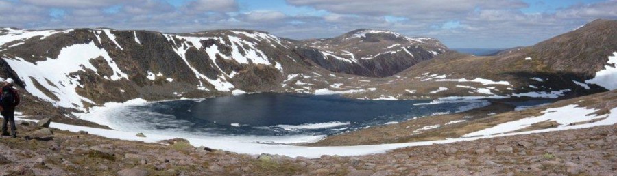
13 of us met in the layby before the Quoich Bridge and set off over the bridge, enjoying the gentle stroll along the valley road to Allanmore under a clear blue sky. After an initial comfort break at Braemar where it was quite chilly (there had been a frost this morning), the sun beat down on us and we were already shedding clothes before we turned left off the path and began the climb up to Creag a' Chleirich (650m), taking our first break just before the summit. From here we enjoyed a good view, but this paled into insignificance by the time we took our second break on the summit of Carn na Drochaide (818m). We seemed to lose an irritating amount of height between the 2 but were amply rewarded after our second climb of the day, as we made our way over the ridge to our lunch on the Corbett summit.
Here we were treated to a truly spectacular view from Beinn a' Bhuird and its solitary tor and huge corrie beside its tor-strewn neighbour Ben Avon, Beinn Bhreac, Beinn a' Chaorainn, through equally tor-strewn Beinn Mheadhoin to Derry Cairngorm, Ben Macdui, Braeriach, Cairntoul, Beinn Bhrotain across to the outliers, An Sgarsoch and Carn an Fhidhleir with many more mountains the other side of the Dee and, in the distance, Ben a' Ghlo peeping over them, not to mention Lochnagar to the south east. With a view like this, we had to have our second stop, although it was a little colder here.
Our descent took us on over the subsidiary lump of Carn na Criche (737m) but after this the path was clearer as we headed for the track and the valley of the Quoich. We left the track eventually to enjoy the view from the footbridge of the Punch Bowl at Linn of Quoich (so similar in rock formation to its neighbour the Linn of Dee) and from there the path through sunlight-dappled woods took us quickly back to the main Quoich bridge and the cars. The only wildlife of note were 4 deer on the hillside of Carn na Drochaide and a large bird of prey in the Dee valley. One unusual sighting of a wildflower was a ragwort plant nearly at the top of the hill, very high up for this flower.
28TH SEPTEMBER Clachan Yell
Photos
Culter Hillwalking Club's September Monday walk was delayed a week due to the very successful long weekend in Blair Atholl. Eleven members and Leo the dog made it to Dinnet for the start of a 26km walk into Glen Tanar by way of Clachan Yell. After the disappointment, for those that took the effort, of the 3 a.m. "red eclipse of a supermoon" the group set off in windless sunny weather with a bit of an autumnal morning nip in the air. After crossing to the south side of the River Dee we entered the western extremities of the Birse oak woods. The path westward was in fact the very old route of the main road south of the Dee, but long forgotten and overgrown with mature trees and seasonal bracken. Forging our way through the first few hundred metres of this undergrowth we must have disturbed a wasp nest, and four walkers, plus Leo became victims to the stings of these angry pests. Within five minutes, inflammation of the stings and Leo's uncharacteristic lack of interest in walking, and panting for breath, forced a quick return to the cars and a dash to the chemist and vet in Aboyne.
A depleted group of eight went on with the route oscillating between heath, bog and birch forest, the boundary zone between the verdant sheep pastures of agricultural Deeside, and the open moorland and hills, still with a hint of heathery purple. The sky was a hazy blue, and the air was breathless, not a hint of wind. A landrover track was located at Greystone Farm and this immediately led into the open with the hint of a breeze to minimise the risk of midges, so a welcome nourishment break was called. The track gained altitude slowly up to the brief levels of Black Moss, and then up further to the watershed from where we then dropped down to Etnach in Glen Tanar. We left the heather on the hills behind us temporarily and did some short-cut reed bashing though very wet ground before finally crossing the Tanar and reaching the main track up the glen.
This was another good point for more refreshments followed by a quick 1km jaunt up to "Rumbling Brig". Here we left the ease of the track to forge cross country following the line uphill of a former deer fence, recently removed by Join Muir Trust volunteers working with the Glen Tanar rangers. The semblance of a path was found making the uphill a little easier, before it ended abruptly on a different landrover track on the southern flanks of a small hill called Red Craig. Here we crossed another watershed into the catchment of the Water of Gairney. Descent soon turned to ascent as we branched off track to head for our goal of the day, the summit of Clachan Yell, not a Munro, not a Corbett, and thus no well-worn "baggers" track, instead a gradual climb though the browning sedges and reeds of this wet wilderness.
The summit of Clachan Yell (626m) - just over 2000 feet in old money - was reached, a strategic point to admire the views and take in more food and drink. Surprisingly at this altitude the wind was fresh, in both speed and temperature, but the summit tors offered adequate shelter whilst giving views to distant hills, Bennachie, Ben MacDui and the closer, familiar Lochnagar.
Descent was heather bashing with the result that we disturbed a number of grouse, until we reached the same track that we had left earlier, which then entered old scots pine forest and a return to windless conditions. But thankfully the midges were not out and we enjoyed the continuous downhill to the river and the main track down the glen to Glen Tanar House. From the back of the estate's Home Farm, well walked by the club on numerous occasions we forged a new route northward marked as a path on the map, taking us through pasture and forest. Back in the Dee valley we stopped briefly to read one of William Cunliffe Brooks' inscribed stones, promoting the value of drinking fresh water rather than alcohol. It read Drink, Think, Thank, but so overgrown was the water supply that we were unable to take his advice. Instead we did admire the neighbouring impressive granite stoneworks of the twin farms and barns of Newton and Netherton that Cunliffe Brooks must have had built, as we walked down, signposted by another engraved granite stone, the "Wicebe Way". (the logic of this acronym of William Cunliffe Brookes is lost on the writer).
A short distance further and we were back crossing over the Dee at Dinnet and admiring the early evening light up and down the valley before reaching the parked cars. By then we had received by text reassuring news of the recovery of walkers and Leo from their encounter with the wasps, 26km back on the walk,.
18TH-20TH SEPTEMBER Blair Atholl
Photos
This was our final weekend away in 2015 and I'm relieved to report that it didn't follow the disappointing weather pattern of the previous 2 weekends but was almost perfect. The aim of the weekend for those who wished it was to polish off a few Munros in the Blair Atholl area and this was successfully accomplished.
On the Friday, those who were able to do so met at the Old Bridge of Tilt car park and, roadworks notwithstanding, finally left at 10.30, making their way through sunlight-dappled woods on the west side of the glen, past the hydro station on the Tilt, past fields of sheep disturbed by buggies shattering the peace of the countryside, to come out on to open land. The Jubilee Shooting area was thankfully quiet that morning, otherwise you might not be reading this report. After the forest, the way continued to dip up and down, sometimes next to the river (near to Gilbert's Bridge for example) and sometimes looking down on it. The only fly in the ointment (wait for this joke, it's excruciating) was the clouds of midges which disturbed our stop near a small bridge, causing this stop to be curtailed before we made our way down to Marble Lodge.
At Clachghlas, 4 members of the party took the track out of the glen while 2 others continued past Forest Lodge to take the stalkers path up to Carn a' Chlamain. Having stopped at the "elbow" where the track turns to follow the ridge upwards, the 4 continued on the track almost to the summit, branching off at the large cairn off track to the top where they enjoyed the broad sweeping views. Of particular note here must be the views of the Ben a' Ghlo mountains on the other side of the Tilt (our goal for the next day) and the mass of many high Cairngorms. The other 2 reached the top not long after. Their downward route was on the track now, and then they walked along the east side of the Tilt. The 4 reversed their upward journey, apart from a steep path down towards Balaneasie to cut off a corner. This was a long walk, usually done by cycling, but much enjoyed nevertheless. 2 late arrivals of the group, enjoyed a 12 mile walk up Glen Tilt as far as the elbow.
Saturday dawned with the same glorious weather so a group of 9 of us left the cars where the road ends north east of Loch Moraig and followed the track until 7 of them peeled off to head for Carn Liath. Of these 7, 2 climbed Carn Liath and Braighe Coire Chruinn-bhalgain (affectionately known to the group as BCCB), and the other 5 continued to complete Ben a' Ghlo with Carn nan Gabhar. What of the remaining 2? Both had already done CL and BCCB, so only needed CNG to complete the 3 and they continued along the track, up the muddy glen to the bealach and from there to the final summit where they later met the 5. Everyone took the same way down from the col, amazingly meeting together back at the cars at the same time. Another perfect day, mission accomplished under generally sunny skies with excellent views, although the wind on top was a little chilly.
Sadly Sunday wasn't quite as good but we weren't really grumbling. After our efforts of the previous days, we didn't fancy a huge walk (like Beinn Dearg which was a possible option) so we plumped for Schiehallion which was new to 3 of the group. The day was overcast and the summit ridge drifted in and out of cloud but the top was reached from the tourist route (in need of a little manicuring in places please John Muir!). There were even more people here than the previous day (we saw very few on the Friday) and many had dogs with them, a cause of some surprise considering the nature of the terrain before the summit. Despite this, ptarmigan were spotted on two occasions and a raven soared high above us. But no other wild life of note.
6TH SEPTEMBER Finalty Hill
Photos
24TH AUGUST Burnt Hill
Photos
Why do I always start with the weather? Well, weather is crucial to a decision on whether (woops, sorry about that) to go walking, how far to go and where to go. Today, we were supposed to be going over Wolf Craig but the weather seemed really and truly dreich on Deeside, with very low mist and rain, sometimes heavy, forecast for the whole of the day, so Catherine made the choice of Burnt Hill instead (last climbed by the Club in April, 2012), a shorter and slightly lower walk. In the end, the mist lifted, we had views of Mount Keen and Lochnagar for example and never really got wet. We also had a super view of our intended hill in the sunshine. So was the decision a sensible one? Actually, it was. When we arrived in Glen Esk, we found the rivers very high indeed, full of peat, and we all thought that the river crossing on our intended walk would probably have proved impossible.
We left the cars in the car park at the end of Glen Esk with mist swathing the surrounding hills and the river roaring angrily to our left. Continuing on our journey along the side of Loch Lee, we stopped at the end for our first break because it was a relatively midge-free zone with a bit of wind, there had been a touch of blue sky above us and the mist was rising. This was the cue for the rain to come, but fortunately its visit was brief, and we crossed the foaming river at the top of Loch Lee to toil up by the side of the burn hurtling down the Shank of Inchgrundle (couldn't resist including that wonderful name) before turning off to make our way up to the summit of Burnt Hill (663m). Our second break was taken just below the summit where, again, there was some breeze to deter the little terrors and after which, we had a good view of a snipe.
The walk along the ridge was most enjoyable with some good views and from the trig point at its end, we continued down the track to Gleneffock farm. A fox was seen on our descent as were 2 large horses and guinea fowl at the farm, along with a very prettily marked hen. Sadly, there was not a hare to be seen, unlike last time when they were very much in evidence. Turning left, we walked along the metalled road parallel to the river before crossing over the bridge, the last stage of our journey being on the road to the car park. But this wasn't quite the end of the story, as half of us went along to the rickety bridge and safely crossed there and back, despite the raging torrent below us.
2ND AUGUST Glen Esk to Glen Clova
Photos
August 2nd was the date of Culter Hillwalking Club's Sunday walk and a bus was a definite necessity for the planned Glen Esk to Glen Clova A to B challenge. A short walk was also planned in Glen Clova/Doll but with only two members interested, they decided to join the longer walk group. Thus it was twelve members and two guests who set off in glorious sunshine on the easy walk from the end-of-road car park at Glen Esk, quickly passing the 16th century remains of Invermark Castle, the gable ends and graveyard of Kirkton and then walking along Loch Lee. The hills were dotted with the bright purple, fully flowering bell heather (Erica cinerea), taking on a more extensive purple haze from the carpets of budding common ling heather (colluna vulgaris). Across the loch the sun illuminated the couple of buildings behind which rises the ridge interestingly named the Shank of Inchgrundle. It is from the buildings of Inchgrundle that the marked right of way rises (but not up the Shanks) and which we would later be joining to descend into Glen Clova.
But our route continued gently beyond the loch up the Waters of Lee to its junction with the Waters of Unich. Here, a sloping slab of granite warmed by the morning sun, was a good spot for a refreshment break and a relaxing view back down the loch. The falls of Unich beckoned with a good volume of water shining brightly in contrast to the rampart of glacially gouged crags that defended the summit of Hunt Hill on our right. We followed the well walked, but sometimes steep path up the glen and it was here, at noon, that the first spots of rain fell from the patchy but dark clouds that had been rolling over the hills from the south. But by the time we reached the falls of Damff the sun had returned, though to the north, Mount Keen's summit was capped by the base of some low stratocumulus. At the falls, we used the footbridge to cross the burn, which according to the map is named the Burn of Slidderies at its upper reaches, and we headed off-path to meet up with one of its tributaries. Crossing this around 1.15pm there was a majority vote for lunch as the sun was still with us. We knew that the weather forecast for the afternoon was not favourable.
After lunch, we followed the tributary on a gentle incline with comfortable grass or short heather underfoot, and then took more of a beeline for the ridge to our south atop of which we joined on to the official right of way path, marked by frequent but small and often overgrown piles of stones (sometimes only one or two stones). A right of way it might be, but it appears to be infrequently walked these days. On the ridge we were exposed to the correctly forecast increasing south-easterly winds, thickening cloud, and definite rain, not a few drops this time - annoying wet rain. In the descending gloom, visibility was becoming decidedly dodgy and no-one found enthusiasm for branching out to the featureless flat top of Muckle Cairn (which on the reconnaissance had afforded fine views of Lochnagar). We followed a recently constructed electrified deer fence as a known and good navigational marker, arriving at the decision-making point of whether to take a slight detour up to the Corbett of the Goet/Ben Tirran, or cut our dampening losses and make the direct route off the top to the dryness of the Glen Clova Hotel. No-one was really interested in bagging Corbetts so we took the Hotel route, keeping to the right of way, still fortuitously marked by the frequent but often overgrown piles of stones (if two stones constitute a "pile"). We had to pay attention to keeping our fourteen walkers within visual range at all times and succeeded in all arriving together at Green Hill (870m), significant only for a large cairn at the very junction for our Hotel-ward path. A compass-taken bearing south put us on the rather faded route that would take us down the eastern flanks of Loch Brandy, and as it developed into a more worn path, it skirted around the outflow of the Loch. Here at 650 metres we came out of the base of the cloud, which hung 20 metres over the surface of the water - atmospheric for sure.
It was a straight run (not literally) 2km down to the Clova Hotel. At these lower levels the rain had stopped (or was evaporating before it reached our heads) and we could at last gain a view of the green, verdant pastures of Glen Clova as we headed downstream. A change out of boots and into the always welcoming Glen Clova Hotel for a quick refreshment. Consensus was of 21km walked amongst typical Angus Glens scenery and typical Angus Glens weather with The Goet/Ben Tirran remaining a target for another Culter Hillwalking day.
17TH-19TH JULY Weekend at Tyndrum
Photos
This is the third year running we have attempted to climb Ben Lui, according to some sources the most beautiful mountain in Scotland. Twice we've stayed at Brander Lodge on the pass of Brander west of Loch Awe and the weather hasn't been suitable. This year, having mopped up the 4 Loch Awe Munros over the past 2 years, we opted to stay at Tyndrum, which is just as handy for our chosen peak but sadly, the weather was yet again against us.
We thought that this July weekend couldn't possibly be a repeat of our weekend away in Skye in May when high winds forced us off the hills but it was. The forecast was terrible for Friday when we had hoped to walk but didn't and Saturday wasn't much better, so we took ourselves off to Inverary Castle in the morning and, when the weather cleared in the afternoon, did a lovely walk from Tyndrum to Glen Cononish and back down to the West Highland Way. The glen gave us a super view of our chosen objective, Ben Lui, sporting a touch of snow and mist. Next year perhaps?
On Sunday morning, the weather looked terrible again but the wind had eased so we took heart from the forecast and 5 of us drove down the long and beautiful glen in which lie Loch Voil and Loch Doine to the car park at the end of the metalled road. We quickly left the car park because of the swarming midges and made our way west to the little settlement of Inverlochlarig (tempting sales of venison here) from where we crossed over the burn and started up a track heading into the glen of the same name. However, our chosen route was up the southerly ridge of Beinn Tulaichean so we branched off towards this ridge.
Although some members of the party had already climbed this mountain from the other side (Crianlarich), Walk Highlands recommends this route. Having toiled up the steep gradient of the more or less pathless ridge, we rather questioned this recommendation. It is basically a long and unremitting slog but when the small rocky summit plateau is reached, it's worth the effort. By the time this was achieved, the group had split into 2, 3 members continuing to Cruach Ardrain and 2 adopting a more leisurely pace.
Poor Beinn Tulaichean gets a bad press in Walk Highlands which terms it "A minor summit on the south ridge of Cruach Ardrain" which seems a bit unfair as it's a nice little summit with views of Ben Lomond, and its nearer neighbours, Beinn a' Chroin, Stob Binnein and Ben More. And there is a drop of exactly 100 metres to the col between Beinn Tulaichean and Cruach Ardrain with a climb back up to the latter of exactly 200 metres.
Both groups (separately) dropped down to the 846 col spot height, the leading 3 ascending Cruach Ardrain before following the other 2. The vestigial track from the col was hard to follow in places and steep, and Ralph Storer and 3 men we met who had come up that way were not complimentary about it but we decided it was probably better than the long very steep ridge we had used to ascend and it made a good circular walk. Before too long, we were back on the easy track which took us down Inverlochlarig Glen past Rob Roy's waterfall (this is Rob Roy country; his grave is farther down the main glen) and finally back to the cars. The weather had been diverse; it was hot and humid with a little rain as we climbed up the ridge and then a surprisingly cold wind blew on us at the top. By the time we were heading down, the sun had come out and it was a very pleasant walk along the track overlooked by the brooding heights of our 2 hills of the day on the west and Ben More and Stob Binnein on the east.
Jackie and Andy set out from a point on the A85 just east of Crianlarich to climb Sgiath Chuil and possibly also Meall Glas. The early morning rain soon stopped as they ascended a rather boggy path beside a burn to a dam. From there they ascended off-path to the summit of Sgiath Chuil, where there are views of surrounding Munros in all directions. The highest tops such as Ben More were in cloud but most were clear. Realising that they would have to drop around 300m to the col, and then re-ascend this to reach Meall Glas, they decided instead to have a leisurely lunch on the summit. They then initially descended by the same route, but just after they dam headed west to pick up the route normally taken from Meall Glas which follows another burn.
13TH JULY Lochnagar
Photos
A select group of members gathered in the Loch Muick midge-ridden car park, encouraged not by the weather as it was at the time, but by the various forecasts. As it turned out the forecasts were correct, at least in part. It rained in the morning, which is what one forecast said, and it rained in the afternoon, which another forecast had said. We're not sure why the dry weather, which they had also forecast, never came our way. The only consolation was that the road was very wet in one place between Ballater and Aboyne as we drove through a very heavy shower, so someone at least was worse off than we were.
It was rather a muggy atmosphere as we climbed up to the cairn on the tourist route of Lochnagar (Munro no. 21) which indicates where the path turns off the track. We were too hot in what we were wearing, so we divested ourselves of our top layer. Whereupon the rain came on again, and so we reversed this process. We stopped at the cairn and met a man whom we continued to meet on our way to the top at various points.
At the col, the men went to look at the loch (meeting that man again) and the women continued up the wonderfully constructed path over the boulders. We all met again towards the top of this section and carried on to the summit where we had lunch. All day the cloud was moving in our vicinity, although we could see the summit ridge from the col, but the only time we were in thicker mist was when we left the summit cairn.
Catherine likes to make our walks up Lochnagar interesting and varied, so her plan was to continue across the plateau to Carn a Coire Bhoidheach (incidentally spelt incorrectly on WIkipeadia) and this we did. The last time the Club climbed this unbelievably unexciting Munro (No. 35) was when Jackie and Andy took us up from Keiloch and included Carn Taggart in the walk. Which makes me wonder if this mountain is ever climbed on its own?
There was much discussion as we left the cairn about the trackless direction we should now follow. The 2 spot heights for which we were heading were out of the cloud at the time, so we made our way towards them over rather mushy ground, taking in a couple of minor burn crossings on our way. The best point of interest here was the 2 herds of deer, one on each spot height, obviously upset that intruders had dared to approach their hallowed ground.
When we reached the col between the spot heights, the vista opened up of a long glen with a burn in it and we started off down here. The terrain had, until this point, been relatively easy but as we made our way down the glen, one member of the party swore they would never again follow Catherine on a pathless route. This glen descends to the little Loch Buidhe above the Dubh Loch path, but we veered off to the right away from the glen to descend the spur on the other side of the burn, and reached the main path.
On this path we met a contractor who was in the process of mending a really bad section and he was informed that James was the surveyor of the path. It was interesting to see the results of the path surveying labour.
We continued down past the waterfall, on to Loch Muick and back along the track, Catherine's least favourite way along the loch but probably the fastest to the cars. On the way, we saw a sandpiper on the loch. Sadly, we were back too late for a cup of tea.
5TH JULY Longer Walk - Glas Maol and Creag Leacach
Photos
This turned out to be a perfect day for walking after the heatwave and then the thunderstorms of the previous week. It wasn't too hot, there was very little wind and yet good views from the summits.
We left the car park at the top of Glenshee and toiled up the stony track, past the unsightly ski equipment to Meall Odhar (this is not pronounced Meal Odd Ha, but, we believe Meal Oar, so just think of rowing), where there is a respite from both the track and the ski tows and, momentarily, from the punishing gradient. After enjoying this, we then headed onwards and upwards along the rather well zig-zagged path to the plateau-like summit of Glas Maol (1068m) where we enjoyed the view, the shelter and our first proper stop. We had taken an acceptable time to ascend the mountain and celebrated one member's first Munro. Many more to come I'm sure.
There is now a gentle grassy descent to the ridge which joins Glas Maol to its little brother Creag Leacach (987m), a ridge which gradually becomes stonier and more narrow towards the summit and before we tackled the really stony section, we took another break in the shelter of the breeze (it couldn't honestly be called a wind). On the summit, we met a lady from Aberdeen on her own, not a common sight on the hills, and we all stopped to admire the view. Although it was quite overcast and occasionally Glas Maol attracted cloud cover, generally this cover was high and we could see a large number of Munros, including those in the Ben Lawers group.
We continued along the ridge dropping away from Creag Leacach and had yet another stop (one member of the party commented on the fact that we had never had so many stops on a Culter walk before) before plunging down the very steep slope to the burn below (one member just nipping up Meall Gorm (759m) for the sheer fun of it). Having crossed the burn, the majority of the party headed for the easily visible path over Leacann Dubh which runs along the ridge parallel to the Glenshee road, admiring on the way the excellent heated bothy, and joined the original path to descend to the car park.
Points of interest about this walk are that there is now a path down to the burn from the 943 spot height, 2 members commenting that this was not visible before. At present, this is quite useful but the steepness of the ground suggests that erosion will most likely occur and cause the path to be less easy to negotiate. There is also now a high path above the burn taking walkers to the Leacann Dubh path, which was also not apparent from above previously. (When last walked, the path along the burn was not good and this may explain the appearance of a higher path). And lastly, the bridge over the main burn taking the path back up to the Devil's Elbow (a route used by 2 members of the party) is now completely rotted away, although it was easy to cross the burn on some handily placed stepping stones.
5TH JULY Shorter Walk - Tarland Circular
Photos
Brenda, Liz and Rosie started off from Tarland Square at about 10.00am. It was very warm and sunny with some high cloud. We went to the entrance of Drummy Wood and started off following the Corrachree Circular Route. This follows a track beside woods and fields to Knockargety Hill and the ascent of the hill is through mixed woodland with views of Mount Keen, Lochnagar etc to the left. We stopped for a break on the top and to admire the view. I had aerial photographs which show clearly the elliptical shape of the hill, and faintly a large oval ditch/rampart around the upper part of the hill. This was an unfinished fort and is thought to date to the iron age, similar to those at Bennachie and Tap O' Noth. It was difficult to see evidence of the fort on the ground, especially as lush vegetation has grown up in the summer. We went to the easterly tip of the hill and found the cairn there, thought to be a long cairn from the Stone Age. This was about 4 metres round. We found a path leading back to the return part of the Circular Route and the Drummy Wood entrance.
This time we followed a shorter circular route to Tomnaverie Stone Circle on its low hill, which went through woods at first then crossed open agricultural land. Just before the circle we came across a herd of cows and calves and had to cross a barbed wire fence to avoid them. We still had to pass quite close but fortunately the cows didn't get too interested! The circle itself has a recumbent stone, and it is one of several good examples of these circles in North East Scotland. There were 360 degrees views of the surrounding hills - Morven, Pressendye, Craiglich, south Deeside Hills, Lochnagar. When looking from the centre of the circle, Lochnagar is framed by the recumbent stone and its flankers. The marked route took us back to Tarland Square. We visited the Commercial Hotel beer garden and had very welcome tea, coffee and scones! It had stayed warm and dry all day, the vegetation was very lush, sometimes the long grass was still wet from the day before. We saw brown and red butterflies and there were sometimes flies which annoyed us. Also many wild flowers eg celandines, speedwell, foxgloves.
22ND JUNE Driesh and Mayar
Photos
The day started with a somewhat discouraging MWIS forecast: constant showers in the morning, clouded Munro tops and 30 mph winds. As it turned out the forecast wasn't quite accurate: no rain (hooray!), yes, clouded Munro tops, but a wind that felt more like sixty mph, although James would argue that I exaggerate.
The walk through the woods up to Corrie Fee from the car park at the Glendoll visitor centre was most pleasant with fresh leaves on the trees and bright green ferns and little indication of the gale to hit us later. On reaching the tree line Corrie Fee presents a most magnificent spectacle, filling your field of view with the seemingly vertical corrie wall and its picturesque waterfall and then the Fee Burn going on to meander its way through a scattering of drumlins on the floor of the corrie. A lesson in glacial geology. We should have seen what was in store for us from the observation that much of the water in waterfall was being blown upwards and sideways.
From the top of the well managed path through the corrie, we walked up the slope to the top of Mayar without too much effort: the wind behind us. On turning to head for Driesh, the wind wreaked its vengeance on us for our neglecting to thank it for helping us up the hill. It was so strong that some of us simply could not move forward without leaning in to it at a most comical angle. Others considered sliding down on their rear ends to avoid being blown over. A couple of lighter weight personal items were torn from packs and were last seen heading towards Montrose at great speed. Having staggered down the slope towards Driesh acting like a bevy of inebriated late night party-goers struggling to get to the bus stop from the door of the last pub, we decided that Driesh was a Munro too far and we headed for the Kilbo Path which took us down the delightfully named Shank of Drumfollow, back to the car park and thence to the Clova Hotel.
Believe it or not I think most of us actually enjoyed the day.
9 hardy souls set out from Deeside for this walk, 1 visitor and 8 members. But the two senior members decided that the spray from the waterfall and the description of weather conditions on the plateau from a couple descending from Mayar boded ill and that, in this case, discretion was the better part of valour. So although we walked with the group some way up towards the waterfall, we finally turned back and had a very pleasant lunch at the entrance to the spectacular Corrie Fee. We then took the green route down the way we had ascended, taking time to read the information posts and turning off on to the blue route which heads up the glen parallel to Jock's Road on the other side of the burn. We crossed over said burn on the substantial bridge at the head of the forest and turned down Jock's Road.
There were times along the track up the glen when the wind had been fierce again and we were glad of the shelter as we entered the forest, where we had another break since we had expected to be back well before the other 7. Imagine our amazement on reaching the car park therefore when we saw that the others had beaten us to it, having not climbed both the Munros. But the timing was impeccable and they had only just arrived so all was accidentally very well planned.
7TH JUNE - Longer walk Jock's Road
Photos
2nd Sunday walks report for June, Jocks Road
Culter Hillwalking Club's June longer Sunday walk was the infamous Jocks Road from Auchallater to Glen Clova, 22 km on foot, four times that distance by the shortest road route, so a Club bus was a must. The longer walkers, thirteen in number, had a pretty early start, but the luxury of a bus allowed the two short walkers to have a lie in. (and very welcome it was too!)
On arrival at Auchallater the weather looked much as forecast, April showers - yep, just two weeks before the June solstice - and a bit windy, but from our "derrieres", so not uncomfortable. A brisk walk and Auchallater Lodge was soon reached and, with a blue patch of sky overhead, the first break was taken at the end of the loch looking forward to the Munro that is Tolmount, a potential diversion later in the day.
The walkers now revitalised, the route was along the northern shores of the loch, remembered as a boggy mess by some longer-experienced walkers, but now, for more than four years, properly and sympathetically constructed with many comfortably spaced stepping stones across the squishy bits. At the upper end of the glen Jocks road climbs steeply up to the higher plateau at around 880m, a stiff slog, and with a much less distinct path; our group became spread out along the way, regrouping as planned on the more level ground up top. Temperatures had dropped by more than 2 degrees and the wind was less hindering, bringing in occasional but very brief showers of rain.
Another refuelling stop amongst the shelter of some big rocks allowed plans to be made for a group of six "Baggers" to tackle the Munros of Tolmount 958m and Tom Buidhe a mere one metre lower. The groups separated with the "Jocks" (male and female) following the true Road over the featureless plateau and the Baggers heading south to the more significant Tolmount, its physical significance resulting in a blustery summit swept by a brief shower which spoiled the sometimes stunning views from the cliff tops down Glen Callater. A quick elevation-retaining curved sweep across the top took us to the somewhat uninspiring rounded bump of Tom Buidhe, where only the 360o vistas set some adrenaline rushing briefly. Our group of Jocks was visible as matchsticks advancing along the ridge of Crow Craigies so it was an easy navigational process to take a bee-line towards them down the soft northern flanks of Tom Buidhe, ending up crossing the headwaters of the White Water burn, living up to its name with the embankments still well highlighted by long ribbons of persistent snow drifts.
Eventually, reunited, the combined thirteen took another brief break, passing the memorial stone of those that formerly perished along the way, the shelter built possibly to help in avoiding a repeat disaster. We then plunged down through interesting glacier-carved geology to the lowlands and planted forestry of Glen Doll. Time was taken to look across at Driesh and Mayar, slightly lower Munros than those bagged today, but subjects of CHC's next walk on Monday June 22nd - consider it Midsummer day.
Over a quick drink at the Glen Clova Hotel, we met the two short walkers and were able to relate observations of large remaining patches of snow on northern facing slopes, a hint of spring at upper levels with the first tormentil, broom and celandine in established bloom, lousewort and milkwort just showing coloured buds, and a very close encounter with a grouse brooding over five eggs. Evolution had ensured the mountain hares were wearing their full summer greyness and the red deer were well up the slopes keeping an eye on us intruders.
7TH JUNE - Shorter Walk Glen Prosen
A small number of us left the church at Glen Prosen at 1pm and made our way up the steepest section of the day, almost to the end of the trees, where we stopped for our lunch, in the shelter of said trees from the wind. We then continued along the Minister's Path until we reached the grouse butts which stride up Knachly Hill. One of us followed the easy track past these grouse butts, finally reaching the top of Knachly Hill (picture to prove it) where the views over Glen Clova were extensive, and then we returned by another route to the Minister's Path before turning away from this to enjoy the wind-free path through the woods down to Glen Clova. We crossed over the bridge, looking anxiously up the glen to the rain coming in, but we didn't get very wet in the end. It was a most enjoyable walk, good weather and views and an excellent place to finish at the Glen Clova Hotel!
25TH MAY Boddam-Cruden Bay
Photos
May Coastal walk, May 2015, Boddam-Cruden Bay
The weather conditions were good: windy, sunny spells with showers. The showers were short. The terrain was coastal so mostly flat although there were some inclinations to be had either on steps or muddy grassy surface.
Starting the walk at Boddam we saw an abundance of flowers: Red Campion, thrift (pink), wild hyacinths, wild pansies and primroses. Especially Red Campion and thrift were present throughout the walk, whole carpets of it!! Catherine pointed out Birdsfoot Trefoil, also known as eggs and bacon, happy little yellow plant loved by butterflies and bees (ref Google) and Roseroot, a rare plant yellow with bluish leaves.
Near Meikle Donnan, a little island, we saw what Catherine thought a "Shell midden", lots of quarries which sometimes left pools of water. It was quarried for red granite, and some of the group thought Peterhead prisoners worked in these quarries.
Our progress was slow as there was so much to see. We were lucky with the birdlife as well, Kittiwakes, Shags, guillemots, razorbills. We had a lunch stop in the Longhaven Nature reserve with a view of a couple of nesting fulmars and a good view of bathing and sunbathing seals, we must have seen at least 40 seals in different places!! We saw grey ones - males can grow up to 2.3 metres - and common seals; their colouring varies from dark brown to pale grey white. Brenda spotted a puffin sitting on his/her own in a rock crevice!!! Finally we arrived at Slaines castle near Cruden Bay. To finish this report a bit of interesting history from wiki encyclopaedia:
Clan Hay was a powerful family in the area having possessed the land of Slains since the 14th century. The clan chief was made Earl of Eroll and built the OLD Slaines castle. This was destroyed and NEW Slains casle was built on the present site. Over the centuries, the castle got rebuilt/remodelled several times and the gardens were laid out in 1805. In 1895 the author Bram Stoker visited the area, the castle may have given him inspiration for the novel "Dracula". In 1925 the roof was removed to avoid taxes. The building has deteriorated since. In 2004, Slaines partnership got permission from Aberdeenshire Council to convert it into 35 holiday apartments. The plans were put on hold in 2009 due to economic downturn.
At the end of the walk cars got picked up and we enjoyed a cup of tea at Cruden Bay hotel. Then we had to make our way home trying to avoid the rush hour traffic which the John and John team managed very well!
15TH-16TH MAY Skye
Photos
Weekend in Skye, May 2015
The weather on the west coast is notoriously unreliable, so when we not only booked our hotel way back in November, but also 2 professional guides, we knew that our plans were likely to be disrupted by the elements and this was to prove to be the case. The forecast during the week before was truly awful but we set off from Aberdeen on the Thursday to enjoy a journey in full sunshine, with cloud free-skies and wonderful views of snow-etched mountains on the way.
In a talk by Geoff Monks of MWIS a few years ago, he claimed that mountain walkers could put up with many things - snow, hail, rain, even sun - but when it came to wind, that was a different matter. And the winds during the weekend were the cause of our change of plans. The guided group had planned to do Munros on the ridge, including the infamous In Pin and the non-professionally guided group planned to do 2 separate Munros, one a day.
In the end the guided group climbed up to the In Pin, in fact they even hugged the In Pin in the mist, but sadly the winds were too strong, so they walked along the ridge to bag Sgurr na Banachdaich, after which, according to comments made afterwards, they had a rather hairy descent down scree and in ferocious wind.
The non-professionally guided group also decided that the wind was too strong and gusty for them to go up high so they drove over to Glen Brittle and took the path up to the Fairy Pools. Here the water level seemed rather low but the group were all impressed by them, the colour of the water, the sub-aqua arch, the waterfalls and some of the rock which looked as if it contained iron. After a stop, (although the requisite progress hadn't been made due to the tourist-like activity of admiring the pools), the group continued up into Coire na Crieche and to the left hand side of Sgurr an Fheadain (whose Waterpipe Gulley had been commented on previously) before turning along a path which took them below the steep sides of the Cuillin Ridge, coming out at a large cairn on the Sligachan/Glen Brittle track. Here the group divided, 3 going back to the car park and the rest turning right and following the burn down to the Sligachan Hotel. Yes, they did get wet and yes, it was windy, but the start of the walk was dry and the wind was at an acceptable level so they all felt it could have been a lot worse and it was anyway an enjoyable walk.
So Saturday dawned, and the forecast didn't seem quite as dreadful as it had done earlier. However, the guides were not happy about the wind speed on the ridge, so they took their group to sample the delights of the Fairy Pools before engaging in a spot of scrambling up the afore-mentioned Sgurr an Fheadain. Looking at the web about this diminutive (689m), conical shaped spur of the main Cuillin ridge, it certainly is an exciting scramble and a climb which is commonly used instead of the main ridge on very windy days. In fact, our party met 2 climbers who had gone up to the main ridge that morning and found the wind so bad, they had immediately descended, so the choice of Sgurr an Fheadain would seem to have been an excellent one and one much appreciated by the group. The non-professionally guided group headed up north, past the Old Man of Storr, to tackle the Quiraing. Now although the summit at the end of the Trotternish Ridge is commonly known as the Quiraing, the Quiraing is actually an area below the ridge itself, the name of the summit being Meall na Suiramach, a Marilyn at 543m. The whole of the Trotternish Ridge escarpment was formed by a great series of landslips; the Quiraing is the only part of the slip still moving and the road at its base, near Flodigarry, requires repairs each year.
The cars were parked north of Digg on the A855 and the party set off past the 2 lochs, Langaig and Hasco, climbing steadily up towards the threatening black cliffs. Having reached the path which runs below the cliffs, they turned right and, after crossing a wall, found minimal shelter from the wind to stop in the valley beneath the cliffs. From there, they climbed up to the area above the cliffs, turned left and followed the path up to a large cairn from which they turned right to the trig point on the rather undistinguished summit. They now descended, gradually at first but then much more steeply, eventually meeting the previous path below the cliffs but farther south.
Another sheltered spot afforded a welcome respite from the wind for the second stop which was brought to a close by a short shower of rain (hail had fallen on the plateau at the top). They headed north again on a good path, passing rock formations with the interesting names of the Needle and the Prison before 2 of them turned off to see the Table (they reported later how impressive it was) while the rest eventually joined the route up and descended to the cars. I must add here that I find the OS map rather difficult to decipher on this mountain, so please bear with me!
3RD MAY Glen Tanar north west
Photos
Sunday May walk, Glen Tanar north west
It is always a nuisance, and also a disappointment, to have to change walks, but after much discussion between Geoff (the long walk leader), Graham (the short walk leader), James (the coach organiser) and me on Friday and yesterday, we all reluctantly agreed that, seeing the forecast, it would be foolish to follow the plan for today and head off to Corgaff. It appeared that, wherever we went, we would get wall to wall rain all day, the winds might well be high, there was a possibility of snow and a white out higher up and the wind chill factor brought the temperature plummeting to a staggering -18 degrees! This all seemed a bit much so, instead of Strathdon as anticipated, we opted for that old favourite, Glen Tanar. , Now we've used Glen Tanar recently as an alternative to the projected walk (In fact, I can't remember ever seeing Glen Tanar in the dry!) but this time we chose the north west side of the valley. The bus dropped us off by the Visitor Centre (handy toilets here) and we set off uphill at a leisurely pace, passing above Home Farm on the big track. From here, we turned off through the forest along a wiggly track (Della's technical term for it). The group, consisting of 12 members and 2 guests, had been told in the car park that the route was all on track and no mud was involved. Sadly, this wasn't to be the case but we bravely ploughed our way through it and continued following tracks towards the west, stopping in a dry (?) spot for a break. We had another break before the track turned north and, as we thought, headed for open moorland.
Alan Crichton had advised us only last month to rely on geographical points on OS maps rather than man made ones and here we found his advice of benefit. It would appear from the map that open ground is reached, then a small wood, and then more open ground before the descent through the woods again but this isn't what we found. Instead, the first open ground was non-existent, being a different type of woodland immediately followed by high pine trees (Slai na Gour) and then the promised second area of open ground.
The descent through the woods was very pleasant, although in places difficult to negotiate because of many fallen trees. We emerged from the woods briefly at the architechturally interesting Little Tulloch, only to return to the woods through a deer fence over which we climbed by aid of an enormous stile, and eventually picked up the old South Deeside road which took us to the Dinnet Bridge and our refreshments at the Loch Kinord Hotel.
This route was chosen for a number of reasons. For a day with continuous rain, it was ideal, being not too long. It was low down, which seemed sensible considering the forecast and it also enabled us to do an A to B because it wasn't possible to cancel the coach at such short notice. Much of it was under trees, thus affording a degree of shelter. And perhaps most importantly to all those hardy souls who braved the elements, it had a welcoming hotel at the end of it which had been prepared for our arrival and provided us with drinks and scones. The thought of this kept us going as we gradually became more and more soggy.
20TH APRIL Cabrach & Creag an Sgor (634m)
Photos
Walks report, Monday 20th April 2015
10 members and 1 visitor left the church at Cabrach Village and made their way past Cabrach House following a track which led south from the village. The weather wasn't at all bad when we left, although the wind was a little chilly then, but it actually improved during the course of the day to give blue skies with fluffy white clouds (sorry James this sounds more poetic!). Catherine very kindly provided us with maps so we could see where we were going (well, most of the time) and these were very useful.
We crossed over a handy and sturdy bridge after Powneed and continued down the valley to Bracklach. Now Catherine had warned us that we might need to cross some fords, and here we came to the first one. No problem, crossed with ease. Before the next ford, we had our first break and then crossed with ease again. Eventually, the track gave out, but not before we had seen some frogspawn in the stream, no all of it particularly healthy, and we made our way through heather to the summit of Dun Mount (602m). There was a wide panorama of views, the principal one throughout the day being the Buck (721m), but we could also see some of the eastern Cairngorms, Ben Avon looking huge, Cullardoch, Lochnagar, Mount Keen, Clachnaben, Kerloch, Bennachie, Morven, hills in the far north and Tap o' Noth closer to us.
We continued along the boundary line towards the west from Dun Mount. Catherine waved her magic wand and hey presto!, a gate appeared in the fence. From there we headed for our highest point of the day Creag an Sgor (634m) where we had our second stop, admiring the views, soaking up the sunshine and out of the wind. It was a steep descent from here initially to a track and then we followed various tracks, some large and some very overgrown, eventually turning northward and through another magically-appearing gate, past Longrigging Hill and along a very gently descending path, towards Cabrach. One interesting part of the path was made up of a long series of wooden planks over a particularly boggy section probably put there for stalkers and another interesting point was the number of abandoned houses on our route. Apart from the frogspawn, we saw many hares of various colours, a large herd of deer, lapwing and one skylark ecstatically serenading us with a glorious song high above.
11TH APRIL Practising mountaincraft day
Photos
On Saturday April 11th, a group of us joined Alan Crichton in Bennachie car park to spend a day on the hill practising mountaincraft. We went through the forest on the main path up Mither Tap and discovered that the map didn't show exactly what we found on the ground. Continuing up, we had a stop after approximately 1 hour and discussed what liquid and food we had with us. Shortly after, we veered from the path and engaged in a bit of scrambling over the rocks and heather, together with helping one another up more difficult terrain than the main path. Joining the path briefly, we then made our way up to the summit via an interesting rocky route which necessitated hand to rock.
After a break for lunch, we made our way to the plateau and here practised grid references, pacing and compass bearings, firstly on path and then through the heather. Dropping down to the well, we made our way back to the main path, stopping briefly to puzzle out what we would do with a casualty and 10 other inexperienced walkers to get everyone off the hill safely.
Altogether we felt it was an excellent day, with some interesting walking and revision of how to deal with a mountain walk, helping others and walking at a speed suitable for everyone for example. We would now like to capitalize on this and arrange a day to continue practising the skills learnt today.
5TH APRIL Hill of Cat
Photos
Well I said in the Poster that this walk is a 'beaut', but I had no idea just how good it could be! To think that just a month before I had been blown off the hills trying to recce the walk in driving snow and freezing conditions; on Easter Sunday the weather was better than most summer days with the temperature on the way home 19C and no wind to speak of at all. But of course these unexpected weather conditions had their downside as well...
Twelve hardy souls assembled at the Forest of Birse car park at 09.15, including one new walker Connor (who does have a second name but I am sorry to say I have forgotten it) and a guest of mine Stuart Bowler. Now the weather at this time was cool, 2C when I set off from home at about 6C as we set off walking. So everyone was clad for early spring, no-one for mid summer. The Fungle Road, whilst a pretty gentle ascent, soon gets you hot and sweaty, and as the sun got higher the layers of clothes started to peel off and the layers of suntan lotion started to go on - for the follically challenged this proved essential, I just wish I had used more as my napper is as red as a postbox today.
With several pauses for water, snacks, lotion, stripping, and easter eggs (yes, someone thought to bring them along for us to share!) we headed up the Fungle tracked by a few white hares and lots of black grouse. The views down the valley behind us were simply gorgeous, we took them in at the various stops. At the Firmounth Road and after hitting the somewhat undistinguished summit at Tempie we split into two groups, with Andy Roberts leading the bulk of the party to the top of Hill of Cat, a more select group (me and Brenda) headed directly to Gannoch. The views were now 360 degree, and with not a cloud in the sky the eager remote hill spotters could indulge themselves; the only notable one my Peak Scanner app pointed out was Mount Keen, which actually looked very different from the direction we were facing. With the groups rejoined on Gannoch, we spotted a large raptor in the distance - the jury (Andy and Patricia) remained out over whether it was an eagle or a buzzard, I plump for eagle as that sounds more romantic. The route home was an amble down towards Birse Castle, again with views across to Bennachie to die for. We hit the car park by 15.30, with 4 of us visiting the Finzean Farm Shop for Easter treats - the other 8 missed out is all I will say!
A great day, great walk, great fun - let's hope the rest of the summer is like this!
16TH MARCH Mona Gowan
Photos
The walk on Monday 16th March was planned as a circuit taking in Craig of Bunzeach, Mullochdhue and Mona Gowan (749m) in the hills to the south of Strathdon.
Our group of 9 met up around 10am at a parking area off the minor road running along the south side of the River Don at GR NJ348108. The weather was cool and overcast but dry as we set off east along the minor road, turning south up a tarmac access road to the croft at Belnagauld. Here we followed a track around the perimeter of the croft, passing an interesting collection of decaying cars before heading east uphill on a good track running next to the forest plantation. Apart from a heavy rain shower, the weather stayed reasonable clear at the lower level and we started to get good views over the hills to the west. We spotted a pair of deer jumping the fence ahead of us then took a quick break at a sheltered spot next to an artificial pond, just north of Craig of Bunzeach.
The weather started to close in as we headed across Craig of Bunzeach and we followed the track west and then south along the edge of the forest plantation on fairly level terrain. It is worth noting that the OS map shows a power line crossing east - west through the shallow col at NJ360089 but this no longer exists. We continued south then crossed the fence into the forest and continued over felled tree debris to a new and substantial forest road. Our route then followed a minor track south and uphill across open heather moorland with some tree regeneration. After a short break, the weather deteriorated with low cloud and light snow. We continued uphill and then arrived at a level area of earlier peat workings near Mullachdubh at NJ355062 around 1pm. The group decided to abandon the off track route up Mona Gowan due to the poor weather and returned back down the same track, then left fork heading west into woodland.
The track in the woodland offered welcome shelter but was overgrown and strewn with numerous fallen trees, making a fascinating if somewhat tortuous route! We reached the new forest road again then took a side route to the edge of the forest. The weather had now cleared and we had fine views across the farmland in the valley of the Water of Carve. We headed down to the main track then north past the farm buildings around Birkford where we were greeted by the caged farm dogs and an interesting collection of abandoned vehicles and machinery, including the remains of a small aircraft! We eventually joined the minor road and returned to the cars around 3:15pm having covered a total distance of some 13km.
1ST MARCH Carn Ferg
Photos
Walks report March 1st 2015, Carn Ferg
The barometer on Saturday night fell to as low as I've seen it and indeed, it was a wild and woolly night. Under these circumstances, and considering the fact that the forecast for Sunday was for very strong winds and freezing conditions, it was decided that the rather exposed summit of Morven might not be the best place to be that day, so Glen Tanar was chosen instead. When we left the Visitor Centre there, the wind was quite strong, but the sky was wonderfully blue, and this blue sky stayed with us all day, despite the speed at which the fluffy white clouds were racing towards us from the west. (Unfortunately, James, our resident meteorologist, was not on hand to identify them for me).
We steadily gained height on the Firmounth Road, stopping after an hour for a break before turning east to ascend past the Hill of Duchery (554m) where we were treated to great views of Lochnagar, Mount Keen and Mount Battock, all with some snow. We then descended to join the other drove road, the Fungle, where we had another stop looking down over the Gwaves. Carnferg was our next destination. 2 of the group continued on the Fungle, while the rest ascended to the large monument on the summit of Carnferg (525m). Their trip to this small hill was sufficient to confirm the decision that Morven would have been an unsuitable mountain, since the more lowly summit of Carnferg was very windy indeed. How much more windy would the more lofty (871m) and isolated Morven have been, and how much colder?
This group then descended off track to join their two companions on the Fungle where the path becomes a track, making their way through open woodland and across a burn to the Guard, where half the party continued down the Fungle and the rest headed back to the cars at Glen Tanar car park.
I think we all agreed that the correct decision had been made, that we had been much more fortunate with the weather than anticipated, and that it had been a most enjoyable day, although at the same time it was a bit disappointing not to have been up Morven. That will be saved for another Sunday walk next year. And, just to show you I haven't forgotten, this walk was one devoid of wild life and people, apart from us!
16TH FEBRUARY Geallaig outlier (601m)
Photos
Monday Walk Report February 2015
Catherine excelled herself on this walk, offering initially 2 routes over Geallaig Hill, but ultimately deciding on the route which started from Crathie car park in case the Gairnshiel Lodge presented a snowy car parking challenge. Not only that, but she provided the assembled company with a map of the route, following on from committee discussions and the AGM when it was decided that the way forward for the club was to encourage more people to co-ordinate walks. As it turned out, this proved very useful indeed.
We set off west along the main road, turning on to the Old Military Road shortly. Considering how small this road is, it seemed to carry a surprising amount of traffic. We left this road after "The Bush" and headed through the forest on a track, emerging on to extensive moorland with wonderful views of a very snowy Lochnagar massif. There was a lot of snow in the ruts, the depth of which Chris plumbed at one point, and care needed to be taken with the icy bits.
After a long walk along this track, we turned off and sheltered from the wind at the Blairglas settlement for our first break. From there, we went off track toward Rineten, taking in The Aisle on the way, an impressive building which is a burial site of the Clan Macdonald. Our route so far seemed very distant from current human habitation; nevertheless, we found 2 f posts providing us with information about our surroundings.
From Rineten, we made our way to Braemaloin, crossed the old military road and then toiled up the long track which takes you up on to the ridge of Geallaig Hill. As we ascended the forecast clouds caught up with us and it snowed for some time, although the snow melted as soon as it touched the ground. The track we were on descended from a point a little below the summit, but half the group (including the most senior member) diverted to take in the shelter (full of snow) and trig point on the very top.
Thus we made our way down in 2 groups, latterly off path, to the Craeg a'Chlamhain mast, where we met up and continued down the track to the road and back to the cars. We saw a number of white mountain hares on our way, the most notable being 2 which bounded on to our track before the first break and, minds on other things, came haring towards us at full tilt, finally realising that we were blocking their path, and veering back off on to the moorland to pursue the activity that all hares enjoy in the spring, in full view of the company.
1ST FEBRUARY Strathfinella
Photos
Sunday walk report February 2015
Culter Hillwalking Club's February 1st Sunday walk was threatened by wintry winds, snow showers and adverse road conditions but nine hardy club members set out to Auchenblae, the start/finish point for a circuit of Strathfinella Hill. After admiring some of the unique architecture of this former flax growing mill town on the banks of the energy providing Luther Burn the route took us out westward through open farm land swept by a fresh northeast wind biting with ice crystal snow showers of arctic origin. A track at East Couliie farm turned us north into the forest which instantly gave shelter from the chill, though wintry flurries fell to our feet from time to time but the sun shone brightly and a morning break was taken sat on the powdery white stuff soaking up some rays. As altitude was gained along the forest tracks, occasional gaps through the planted trees allowed outstanding views across the verdant, snow-free lower levels of the Howe of Mearns. Opportunity was taken in such inspiring surrounds to hone some map reading and navigational skills.
Another sunny break for lunch prepared us for a further exposed chilling section of the route which also happened to be the steepest gradient of the day. With bodies hot on the inside, chilled at the extremities, there was still comfort in stopping to admire new vistas to the snowed-in Cairn O Mount Road at Clattering Brig, along the horizon ridge stretching from the Cairn southwest through Hound Hill, the intriguingly named Hill of Remora, then beyond Glen Esk to the Wirren Ridge, about 18km away and traversed last summer.
The track edged back into the forest again but the wind had still managed to blow through creating a gallery of transverse snow drifts and a barrier of encrusted trees. The legs gained a good workout stepping over or through the drifts before we went in search of the well hidden Strathfinella 414m trigpoint. Very much redundant, the trigpoint had long been overgrown by the planted trees, maximum viewing distance from the point was no more than 15 feet, and there was barely room for our group of nine to assemble. After recognition of this formerly strategic location we headed onward encountering some more widespread drifted snow before heading off onto a true footpath (doubling as a mountain bike trail). The path had a couple of inches of snow, and the neighbouring trees, under the weight of an even greater covering, where bent over almost engulfing our way forward. No distant views, but our immediate environment was Alpine like, and one to be absorbed as we made our way through.
And then, a firebreak opened up the view, back to the snow-free agricultural lands around Auchenblae. As we descended, the snow cover became less, the path took us over the ice encrusted brown soil of last year's tattie field before a stretch of tarmac led us back to our parked cars, 17km walked from the morning departure. A quick change of footwear at the cars before we all dived into the Old Post Office Café, where they had intentionally stocked up for us with absolutely fresh, crumbly scones and a warming tea or coffee.
26TH JANUARY Fourman Hill and Tillymorgan Hill
Photos
Monday walk, January 2015, Fourman Hill and Tillymorgan Hill
As the Banchory contingent passed Tap o' Noth, a black cloud reared its ugly head in front of us and soon obvious flakes of snow were spattering the windscreen. We all wondered why we had driven all the way to Huntly to be bombarded by the winter elements. But when we finally reached our meeting place, the curiously named Bognie Hotel, the sun had come out and we began our walk in a much more optimistic mood.
We climbed up from the cross roads to a farm and an old church and graveyard along a metalled road. This brought us eventually to a sight of our objective and the end of the road, after which we followed a track through the woods, eventually coming out to moorland and the trig point on the top of Fourman Hill (344m). Marilyn 1 safely achieved, but we didn't hang about here as the wind was not blowing hard but was definitely too chilly to sit and have our first stop, so we descended on a small path next to a fence which brought us out on to a track where we turned left.
Here we had a stop, not in the sun but in the lee of the wind, and with a wonderful view of the snaking River Deveron below us and, in the distance, Knock Hill, which we had climbed in January 2013 in a snow storm. Fortified by an after eight, happily provided to all of us by a member of the party, we continued along the track which brought us back to the metalled road and our way down.
Now for Marilyn No. 2. We drove back along the A97, past Morgan McVeigh's and turned left along the A920, where we parked near to the first cross roads. We climbed north, first along a road again and then along a track which led to some woods. Here we enjoyed our second stop in the sunshine, complete with a lovely view of Bennachie. The track continued until we reached a turn to the right. Here the map seemed to diverge from what we saw before us. There was much discussion therefore as to which was we should go. June, who was leading us (and had made a good job of the route up Fourman Hill) decided in the end to turn right. This track led us to a path which wound steeply up through the woods until we came out on open ground.
The "summit plateau" of the Hill of Tillymorgan shows evidence of substantial slate quarrying over a wide area so we were careful where we stepped. When we reached the trig point, there was yet another panoramic view, this time down to Insch, across to our previous hill and Knock Hill yet again, with Ben Rinnes and the Buck in the distance and of course, Bennachie. Having been up Foudland Hill the other side of the main road, I had always wanted to climb the Hill of Tillymorgan and wasn't disappointed. For a lowly Marilyn, (381m), it packs a good punch in terms of a pleasant walk and good views.
From the top, we proceeded in a approximately northerly direction along the edge of the wood and latterly on an obvious path, coming out on an extremely icy road (there was a lot of ice still lying on our route and we were all thankful for the later date of this walk; had it been the previous Monday, both roads and paths would have been a great deal more treacherous) which led down to another road, in its turn taking us back to the road we began on. I can't remember doing 2 quite separate hills before with the club, but these 2 were well chosen by Catherine and definitely worth driving that distance to enjoy. (and the Hill of Tillymorgan is conveniently close to sample the delights of Morgan McVeighs afterwards!)
4TH JANUARY Muir of Dinnet and Loch Kinord
Photos
Sunday walk report January 2015
Where were you ladies? For the first time I can remember since I started walking with the Club in 2007, there were more men than ladies on this walk. 14 people walked with us, 9 men, 5 ladies (including a visitor) and Leo the dog whose behaviour was impeccable!
This was a similar day weatherwise to the last Sunday walk in December 2014, cold but sunny all day with little wind. (However, yesterday, it was icy and at times quite treacherous underfoot on a path where the moisture had frozen to give black ice.) We set off in this sunshine from Cambus o' May and made our way east along the old railway line. Happy conversation helped this rather long section to seem shorter, with members catching up on their holiday season remembrances.
We were following a route from a book which took us north from the Dinnet x roads, through a small gate and to a path which goes north of Clorack Loch where we made our first stop in the woods in the sun, (the path suggested in the book has disappeared, with a fence now crossing it). We then headed for Loch Kinord itself, looking beautiful in the sunshine, where we read the information posts about the crannog and the Celtic Cross. Enjoying the walk through the woods and learning about the peculiar traits of hoof fungus which is ubiquitous in this area, we reached the Burn o' Vat car park, picnic site and toilets where we had our second break.
We were due to go to see the Vat and then climb up above it and along the hillside to the track but one member had other ideas, and suggested we go through the Vat and follow the burn up to the track. The other walkers were happy to do this so we had a good scramble up the waterfall and along a sometimes slightly challenging path beside the burn. Burn o' Vat is a fascinating place and the path in the glen behind also possesses its aura of magic, a narrow wooded glen with steep cliffs and relatively recent rockfalls at times. When we reached the track, we turned left and followed this back to the car park, taking the longest route through the woods. We were back in plenty of time to go to sample the delights of the Loch Kinord hotel who provided us with gigantic scones.
This walk has been on the walks programme a number of times in the past and comments about the walk were very favourable from a number of people; firstly, of course, the weather was good, the walk was varied with the easy bit at the start and the more exciting section by Burn o' Vat later on, the length was acceptable for just after Christmas and the shortness of the days, the venue well chosen because it was easy to reach had the weather been inclement, and the views breath-taking.
We'll try to replicate this in walks to come in 2015!
15TH DECEMBER Creagan Rhiabhach (533m)
Photos
Monday Walks Report December 2014
Our final 2014 walk took place on one of those perfect winter days, crisp and cold but with blue sky, sun shining all the time and spectacular views over the hills beyond. We met in Ballater car park and made our circuitous way to the Pass of Ballater Road, taking care with the ice underfoot. Having walked a little way along here, we turned off to go up to the mast which overlooks the Dee Valley, where we had our first stop. The track up to here became progressively snowier but not enough to halt the progress of a 4 x 4 vehicle which sped past us up the hill.
Now the views from this stop were good, but the trees rather get in the way so we returned to the junction and made our way up Creagan Riabhach (533m). Here the view proper started with a wonderful vista of snowy hills as far as the eye could see to the south and south west. We met one solitary walker as the views continued on our way to the highest point of the day (547m and unnamed). From here, we descended to the Gairn valley through woodland, stopping on the way down briefly. We followed the valley to the main road and then picked up the 7 Bridges path to take us back to Ballater and a good but turkey-free lunch at the Deeside Inn.
This was a super way of rounding off our walking before Christmas and we must thank Catherine for finding a new path, the drivers Catherine, June, Geoff and Kendall, and the company of our non-members Ryan and Leo, the latter of whom thoroughly enjoyed rolling in the heather and then the snow. In fact, I had visions of him rolling down the mountain.
7TH DECEMBER Hill of Fare (Marilyn)
Photos
December Sunday Walks report 2014
This was Rosie's walk which she was unable to attend due to work commitments and when she, Brenda and I did the original recce, it was a beautiful day with superb views over Deeside. I was very much hoping that this weather would be repeated for the walk itself. It was raining when I left the house at 8am but before long, the sky cleared and yes, we were fortunate to experience a very similar day.
We left the quarry car park above Torphins at 9.20 and followed the track up through the forest, meeting the usual army of dog walkers en route. Then, in much more open terrain, the track becomes a pretty narrow path up through heather and old forest, unmarked on the map. On the recce this was not so much a path as a small burn but today, although there were very squidgy moments, the ground was a lot drier.
Near to the plateau that constitutes the large area of high ground that is Hill of Fare, we reached a track and, although we hadn't been going the statutory hour, we had a break before we experienced the windier conditions higher up. It wasn't a long break, however, as the temperature wasn't all that high. Soon we were near the summit of Hill of Fare and half the party struggled through the dense heather to reach the cairn on the rather undistinguished top of 471 metres.
Our second stop was at the Hut where we enjoyed the sunshine, continuing to the summit of Craigrath (436 metres) and descending the Skairs from there. Here we had another detour to look at the Shooting Lodge, a 3 storey building which has seen much better days and is now an slowly crumbling structure with large cracks in one wall and a necessary sign that it is dangerous. We then descended through the pleasant forest, made less attractive by recent heavy logging which has chewed up the ground substantially and was very muddy indeed. At a fork in the path, the left hand track of which goes down to Raemoir House Hotel, we turned right and followed the track past a house and back down to the bus waiting at the layby, arriving at 1.30pm. From here we went to Mains of Drum for lunch.
2ND NOVEMBER Brown Cow Hill (Corbett 117)
Photos
Under John Fowler's guidance, we all enjoyed our walk today. His report is as follows: 18 walkers set out and 9 returned: a 50% attrition rate which is considered good for a novice leader. It was cold-ish and showery up to Brown Cow Hill and onto Meikle Geal Charn, where the sun came out to reveal Ben Avon in all its glory. By that time the temperature had dropped noticeably and the wind was very strong.
At this point 9 walkers decided they were fed up with the astounding (in his own opinion) leadership and went off to investigate the Wells of Don, leaving the more sensible remainder who just wanted to get out of the freezing wind. They headed off down the hillside to join up with a track which later turned into the road along the main valley. Their walk took five and a half hours from start to pub. The walkers were marched till they dropped; indeed someone may have a photograph of Pete flat out on the tarred exit road. The break-away group returned a little later."
The walk was memorable for the fact that it was a Good Hare Day - loads of them here, there and everywhere, brown ones, white ones, brown and white ones, white and brown ones, all dashing across the hillside as if the devil himself were after them. Then there was the brown cow wearing antlers which was spotted on Brown Cow Hill and lastly a wonderful selection of rainbows, proof of the variable weather we experienced throughout the day.
20TH OCTOBER Green Hill (570m)
Photos
Walk Report - Green Hill, Monday 20th October 2014
Despite a damp drive out to Strathdon, the weather cleared as the group assembled in the car park at Bellabeg and conditions were calm and mild despite warnings of the coming storm (tail end of Hurricane Gonzalo) later in the day.
We set off around 9:45am along the track beside the Water of Nochty, passing 'Lost' and scattered several pheasants and a couple of deer in the nearby fields. We made good progress to the first bridge where the surrounding woodland had recently been cut down, leaving the landscape rather bare. We continued west along a good track following the Water of Nochty, finally leaving the felled forest enclosure and took a short break on open ground near the confluence with the Quillichan Burn.
Suitably refreshed, we continued along the track until we had to divert around the property at Tolduqugill, accompanied by a chorus of barking from adjacent kennels! We picked our way along a grassy track which soon crossed the burn and started to climb through the narrow gap between Hill of Righorach and Knapps. Finally we reached open ground at junction of estate tracks where we inspected a substantial open shelter, complete with table and benches. However, we decided to head for the nearby lochan and have our lunch break outside the modern cabin that was locked and guarded by several fearsome looking animal skins mounted on the walls. Our break was rewarded with sightings of two large predatory birds - possibly Buzzards but there was speculation they could be Golden Eagles. Sadly, no binoculars were available to verify this!
Our walk continued with an easterly climb to the ridge and we headed off track to the summit of Knapps, overlooking Water of Nochty to the north. From there we continued along the ridge line, scattering grouse and the occasional mountain hare to the outcrop of Red Craig where the surface was scattered with weathered chunks of rock. Our group split with some continuing to the summit of Green Hill (570m) and the others taking the main track skirting the hill.
We re-grouped for a quick break then decided to head up Breagach Hill, following a recommendation from a chance conversation with a local at the car park. By then the weather had cleared with some late afternoon sunshine affording fine views across Strathdon and the surrounding hills, as far as Clachnaben to the south and Ben Avon to the west. We then headed due east downhill, following a line of grouse butts and entered the woodland below. From there we worked our way around farmland and through conifer plantations to finally join a new way-marked track. This took us behind the primary school and the Doune of Invernocthy Castle then back to the car park, arriving around 4pm.
Our convoy of cars then headed back and we managed a quick tea break at the Alford Bistro just before closing time! A great day out!
5TH OCTOBER Creag nan Gabhar (Corbett 114)
Photos
October 5th Sunday Walk Report Creag nan Gabhar
Before you read the walk report for today, please do remember the walks meeting at the Popin in Culter which takes place at 7.30pm on Thursday 16th October. Everyone is very welcome, even if you don't intend to “lead” a walk, and any suggestions or comments will be gratefully received. And now for the report:
A chilly wind was blowing when we got out of the car at Auchallater Car Park and the mist on the nearby hills was lower than forecast. 11 club members and 2 visitors set off up the track which leads to Loch Callater, turning off to climb up along another well-made and zig-zagged path in the direction of Sron Dubh but turning south to follow the ridge up to Sron nan Gabhar. Although the map shows the path finishing there, we appeared to follow a reasonably marked path, continuing on the ridge, to the summit of Creag nan Gabhar, 832m. Unfortunately, it was misty here, so we had no view at all - the forecast continuing to be incorrect.
We visited the 2 cairns on the top of this Corbett, just to make sure we'd reached the summit, and then plunged off track down the steep slope in a south easterly direction, out of the mist and with a good view of Loch Callater, to reach a track where we had our second break. This would have taken us down to the Callater Burn crossing which has no bridge, so it was decided that we would take the small path off to the right which led to Lochcallater Lodge over a substantial bridge. Here we stopped to talk to some equine friends before taking the main track back down the glen to Auchallater. There was little wild life on this walk; we saw a buzzard on the way along Deeside, some fast running hares or rabbits on the way to Loch Callater and a few very fuzzy caterpillars on the way down from the Loch.
Although it was a bit cold to begin with and disappointing to be in the mist on the summit, particularly when the day cleared up considerably once we were down in the glen, we didn't have any rain, no-one was blown away on the ridge and I think we all enjoyed the walk.
22ND SEPTEMBER Airlie Ridge & Hill of Couternach (512m)
Photos
September 2014 Monday walks report Airlie Ridge
Although the Airlie Ridge does not possess the height of its neighbours Dreish and Mayar higher up Glen CLova or the corries of Loch Brandy and Loch Wirral the other side of the glen, it affords a pleasant “ridge” walk along the southerly end of Glen Clova with wide panoramic views. And we had a wonderful autumnal September day (although strictly speaking, it was the last day of summer) to enjoy our walk.
To accommodate all needs, we left cars scattered through Glen Clova and walked up from the cemetery through the woods to the monument. It is a pity that it is no longer possible to ascend this as it can be seen from miles around but it was a good spot to have our first break. The monument was erected in 1901 to the memory of the ninth Earl of Airlie, who was killed in 1900 on Diamond Hill in Pretoria at what must have been a fairly substantial cost in those days of £1,300.
From here we headed along the path past spot height 459 and The Goal to the Sneck of Corinch. An interest in navigation had been expressed, so we had a “Deputy Leader” for this part of the walk and a very good job she did of it too. Maps were studied by the party more than usual, but of course, it was an ideal day for this with little wind and sunny enough for us not to get cold when we stopped. Not only did we learn more about navigation, but also about sea eagles from a man who had been looking for them and who gave us a little talk about how common they had become, not necessarily on the coast.
We continued over Hill of Couternach (512m) and Hill of Balbae (494m) with a stop on the way before descending Carn Leith (439m) and turning towards the glen. Where the Minister's Path separates from the path onward to the woods, there is a signpost and we stopped here before the longer walkers headed off to the woods and the shorter walkers enjoyed the sunshine before following the Minister's Path down to Catherine's car. The former group took the path through the woods, coming out on the road opposite a signpost pointing the way to the Glen Clova Hotel. They followed this path over the bridge crossing the Clova, and along the road and path to the Hotel.
We were very fortunate with the weather, ideal for walking.
12TH-14TH SEPTEMBER Ben Klibreck & Ben Hope (Munros 195 & 256)
Photos
September 2014 weekend away in Sutherland
A long way to drive, you may say, but definitely well worth the effort for what turned out to be a special weekend away. Due to circumstances beyond our control and not in our original plan, we met at Lairg for lunch on Friday on a very murky day at a super café Catherine found called the Pier. If you're ever in the vicinity, it's worth a visit. Afterwards, we visited the Falls of Shin, walking round the forest and sampling a trim trail as we went. By this time, the sky was blue so we drove over to Raven's Rock Gorge, a small but nevertheless imposing gorge in woodland nearby, which afforded us some geological instruction by a member of the party. Then it was on to Altanharra, famed as being a cold spot in the UK, and its excellent hotel, with views on the way of Ben Hee and our goal of Saturday, Ben Klybreck, a large mass of mountain looming up from the plains below.
Saturday dawned great and misty with ideal conditions for midges, so we drove to our starting place and quickly left the cars to trudge up an ATV track to spot height 544 where we stopped for a midge-free break. We continued, traversing the mountain's long south west flank to a suitable lunch site before our final assault on the summit. 3 of us came down the same way, 4 made a detour to another spot height, 808, and we all made a final stop at 544 again before heading for the cars and the culinary delights of the hotel. We made good time, despite the very hot and humid conditions and, although the views were very hazy indeed, we were never in cloud.
On Sunday, the higher tops were in mist but this eventually burned off during the day, aided by a greater wind than we had experienced on the previous day. We drove along the single track road to Ben Hope (grass in the middle to show you how small the road is, but it had lovely views of the hills farther west). We parked the cars at Altnacaillich and legged it along the road to the waterfall which is the accepted route up the mountain. Despite dire warnings, we found this path very acceptable (the land was rather dry, so this probably helped) and enjoyed a sheltered stop just before we reached the plateau above. From here it seemed to me to be a long haul to the summit and we were now walking in some mist but at the trig point there was a shelter constructed against the elements and a HAM radio enthusiast broadcasting with his aerial.
Irritatingly, we kept getting fleeting views of the surrounding hills, lochs and sometimes more distant ones of the sea on the north coast, but after we left the summit, the mist finally went, revealing Ben Hope in all its glory. We came down to the plateau and walked back along its rim, crossed over a lovely waterfall, and followed a well-defined track straight back down to Altnacaillich and the cars. Because Ben Hope rises almost from sea level, it is a most imposing mountain with its interesting geology and the impressive view of its bulk brooding over the valley floor far below is one I'm sure we shall all remember.
Altogether it was a super weekend. Despite sometimes not having the views we would have liked, we had no rain or wind and Sutherland must have appeared at its best, a lovely part of the world which I for one would like to visit again. Because the mountains are so spread out and isolated, they tend to present a special character of their own, very different from those farther south which are more huddled together.
7TH SEPTEMBER A - Hill of Wirren traverse (Graham 136) B - Hill of Rowan
Photos
Sunday September walks reports 2014 - Hill of WIrren and Hill of Rowan
Hill of Wirren
Culter Hillwalking Club's September Sunday walk was a traverse of the Wirren Ridge from Tarfside to Edzell. A bus was in order for this 21km A to B walk, which took both the main and short walking groups to Dalbrack Bridge, 2km up the North Esk as the intended start at Tarfside was scuppered due to the final blocking of the very rickety and decidedly unsafe Buskhead Bridge, see an interesting article in the following link: http://www.brechinadvertiser.co.uk/news/community-news/bridge-closure-move-branded-unacceptable-1-3409318
Sunny weather in Peterculter had changed to light rain at disembarkation and for some it justified waterproofs but that was the only time they were needed, despite showers often being observed over distant ranges. The main walking group of fourteen left the bridge along the track to the farm of the same name then headed uphill on what was the old drove road from Glen Esk to Glen Lethnot and markets further south. Strictly following the pleasantly old and green drove road required the crossing of a small burn that caused an early morning challenge, before our route traversed uphill steadily to a bealach near Cowie Hill from which there were good views back to Glen Mark, capped with blackened, threatening skies. Now however the ancient drove road had been bulldozed into a modern estate landrover track with no pleasances whatsoever. The customary break after one hour of walking was taken at the ford crossing of the Burn of Berryhill after which it was another uphill jaunt to the flanks of East Knock, before descending again to the “Clash of Wirran”. (Clash = “A cavity of considerable extent in the acclivity of a hill; . . . the interstice between a large hill and a smaller one adjacent to it, and intervening between it and the plain” (Sc. 1808 Jam., Abd.2 1937).) Although not part of this day's walk, descent through the Clash shows it to be akin to a very miniature version of the southern half of the Lairig Ghru with cliffs, screes, boulder fields, pools of water and an emerging burn.
From the Clash at 360m, the real ascent began, still tramping the modern landrover track. Indeed it was “dual carriageway” madness along this estate boundary ridge with parallel tracks, and parallel fences, one for each estate, scarring the environment. Visually painful, it however made for easy walking, helped by a cooling blustery wind from behind, to the first summit, West Wirren at 628 metres. This spot afforded extensive views northward across Glen Esk to the summits of Mount Keen, Mount Battock, Clachnaben and Kerloch. A bit chilly to rest here, we descended to the next bealach to find a grassy embankment for a good lunch stop and views up to the cloud-kissed broad summit of our next Hill of Wirren at 678m.
The summit was characterised by an area of peat hags and a forlorn trig point with the advantage that the eternal landrover track took a drier detour and we thus had to go off-track to reach the summit. After the summit rituals we continued down its eastern hags before rejoining the landrover track which had recently been hacked out of the hillside leaving an eight foot peat “cliff” that would take centuries to slump, slip, re-stabilise and finally re-vegitate. A couple of mountain hares in summer attire showed us some speed of foot.
East Wirren at 639m was easily reached with its own trig point offset eastward from the highest point, but offering unrivalled views to the Firth of Tay, and across our destination, Edzell, to Montrose basin. A steepish descent brought us down to the Hill of Corathro which could be considered to be the southern sentinel hill of the entrance to Glen Esk. The blazoned land rover tracks gave way to more verdant, attractive farm tracks and rabbit country. In a sheltered spot we had time for another snack before working our way through agricultural land to the beech woods on the southern riverbank of the North Esk and its gorges and pools. We reached Bridge of Gannochy well ahead of schedule, and by chance we found our bus and driver parked at the “Blue Door”. He brought news of the “short walk” participants and so we followed in their footsteps for a further forty five minutes from the bridge, down the riverside to catch up with them at the Panmure Arms in Edzell.
Hill of Rowan
The club last climbed Hill of Rowan as a Monday Christmas walk when we had beautiful crisp, clear, sunny weather and the memories of an excellent walk remained strong with me, so when Hill of Wirren was chosen for our walk this month, I thought it would be a good idea to return to Tarfside for our shorter walk over Hill of Rowan.
The Buskhead Bridge closure made more of a difference to the B walk unfortunately, but from Dalbrack, we followed the road up Glen Esk a little way, and then bore right through a gate and along a track which winds round the west of the hill and takes you up to the summit in an hour, where it was very windy. The Maule Monument here was built in 1866 by Lord Panmure in the memory of seven members of his family - it is also dedicated to Lady Christian Maule, Lady Ramsay Macdonald, and Lord Panmure himself - and it is an imposing structure. Although this is only a little hill, 380m, it enjoys a wonderful panorama of the wide bowl of Glen Esk.
From the top, we retraced our steps down the hill, continuing towards and past Westbank Farm, before turning sharply right and climbing up to and crossing the col south east of Cairn Robie to drop down to the next valley and Milton Cottage. We followed the road from here back to Tarfside and a bite to eat. Knowing that our walk would take nothing like the time of the A walk, we retreated to the Retreat for slight refreshment and then continued walking along the River North Esk back to Edzell and the Panmure Arms.
Not much wild life was visible, although lots and lots of fungus of different sorts. We saw 2 buzzards, many rabbits (not with the buzzards) both alive and dead and a number of wheatears (which I also saw on the recce). The four of us very much enjoyed our walk and we hope to continue to offer B walks whenever possible.
18TH AUGUST Lair of Aldararie (832m)
Photos
Monday August 18th Walks Report 2014
August? Was it really August today? More like October, but perhaps we'll have an Indian summer then. We left the car park at Glen Doll with the comment that it was a little more chilly than we had anticipated and climbed up the Capel Mounth path, stopping in the sunshine and the lee of the wind before we reached the more open land to enjoy the views of Dreish and Mayar across the valley. When we reached the moorland top, the wind definitely didn't feel as if it belonged to August but we had a marvellous view of Broadcairn, Carn Taggart and the mass of mountain that is Lochnagar, including the Glas Allt path to the summit, but from that direction, clouds were gathering and soon we were donning our wet gear against the rain. This was to be the pattern for the rest of the day - sunshine one moment and rain the next but happily we were never in mist.
We turned off the Capel Mounth path to the right to scale the undistinguished summit of the Corbett Ferrowie (801 metres), undistinguished because, despite its Corbett status, there is no height for it on the OS map. From here, we were trackless for some distance, making our way across the plateau over not the easiest ground to our next hill, the Lair of Aldararie (832 metres, this only a sub Corbett top but with its height marked on the map). The summit of this hill had the distinction of being the site of Highland Games up to the 20th Century, being easily accessed from surrounding glens and having a fine turfed summit free of heather, tussock or peat. However, we personally thought it had rather a lumpy summit for such pursuits.
We had a second stop on the side of the interestingly named Boustie Ley (876 metres), not as pleasant as the last as it was difficult to find a spot out of the wind and the sun was hidden behind clouds by this time, so we were happy to move on and generate some heat again. We headed for the top of the cliffs which shelter Loch Brandy; we did consider going round it over Green Hill, but by now we were ready for the delights of the Glen Clova Hotel, where we had left a car, and so we took the shorter route down the Snub to the valley and a welcome drink.
On our way, we saw a herd of deer and a couple of hares which turned out to be nothing to the wildlife on the road by comparison.
3RD AUGUST A - Ben Rinnes circular (Corbett 106)
Photos
Report of Sunday A walk, Ben Rinnes, August 2014
After a night of torrential rain, but with a weather forecast of improved conditions, fifteen folk boarded the coach for the August 2014 Sunday walk at Ben Rinnes. The coach dropped the full distance walkers on the eastern flanks of the hill at an elevation of just under 400m and they made their way up the broad, well trodden track in dry conditions with good sunny periods. After a distance of less than 4km the 840m main summit tor of Ben Rinnes was reached, this point being adorned by a conventional concrete trig point which, since its time of redundancy, had been painted white and capped with a bronze plate sponsored by the Whisky Industry, showing directions of the various, and many, distilleries, and for those with other interests, one or two of the distant hills.
The cloud had increased to block the sun and the wind took on a chill, so advantage was taken of sheltered bowls amongst the Ben Rinnes summit tors for a refreshment break, with views down Speyside to the north east, and northward to the Moray Firth. Idle time and views of distant wind farms lead to entertaining discussions on how to mitigate their visual impact (paint them green!!) and their future beyond September 18th.
With midday barely passed, there was plenty of time to make a “Tour of the Tors” so the post snack pathway took us through the “Lady's Chair” (1:25,000 map) to the impressive “Scurran of Well” (Scurran = pinnacle or peak of hill) which offered even better photographic opportunities of Speyside, especially as the cloud had evaporated somewhat and the sun was winning the day. We disturbed a flock of upland sheep and on the horizon saw a lonesome deer avoiding us. After some individual scrambling amongst the tors we turned our backs on Speyside, cutting off-path on a bee-line for the next tor, Scurran of Morinsh at 760m. This now commanded views to the south and, to the west, the Cairngorms generating overcast conditions and our first sign of falling rain. A couple of summer-coat mountain hares rocketed across the landscape not far from us
Stiill off-path our route followed the lichen covered posts of some redundant boundary fence across the bealach to the minor bump of the interestingly named Hill of Knocknashlag. A refreshment stop was made at a modern, informal cairn on its flanks before what proved to be a taxing downhill stumble through a nasty mixture of slippery deer grass tussocks and clumps of blossoming heather with deep hidden ruts and holes in between. Twelve walkers, found twelve routes down the slopes before regrouping close to a section of the Tomintoul spur of the Speyside Way. This was easier walking, although gradually gaining 150m in altitude, which took us over the watershed towards the Burn of Tervie just before its confluence with the River Livet at Glenlivet. On descent, the Speyside Way entered into sheep pasture and typically for a “Way”, followed the boundaries of fields and dwelling places whilst offering good views of the local distillery. However the earlier Cairngorm showers had moved our way and some rain briefly fell before we reached our destination, Glenlivet Community Hall, 17km and 5.5 hour making for an excellent walking day.
The coach took us to the Croft Inn where we met up with those who had taken a shorter walk, learned of their adventures and enjoyed liquid refreshments of various types.
3RD AUGUST B - Dufftown
Sunday 3rd August 2014
August “B” Walk
Following the departure of the members undertaking the “A” Walk, three of us remained on the coach, travelling towards the vicinity of Tombae. As the narrowness of the road presented some difficulty in locating the elusive Allanreid Car Park (our intended starting point), we began our walk on the forest road, leading up through the Cairn Muldonich plantation. The weather was sunny and clear, affording us lovely views of the Ladder Hills, before entering the trees.
We then continued uphill on the track, to reach the shoulder between Cairn Muldonich and Cairn Dregnie. Due to large areas of tree-felling operations, we were able to enjoy many wonderful views of the surrounding hills, including Ben Rinnes, as the planted spruce and pine trees are still too small to obscure these. The track then descended to a small ford, crossing the bridge over the Allt a'Choileachan burn, before crossing the Allt Cullach burn, to enter the Forestry Commission plantations.
At this point we left the track, choosing instead a small path to the right which follows an old drove road up to the site of the Battle of Glenlivet. There we found a panel providing information about this battle, which was fought in 1954, between the Catholic Earls of Huntly and the Protestant Royalist army led by the Earl of Argyll. Despite being far fewer in number the Earls of Huntly defeated the forces of the Earl of Argyll.
Rather than retrace our steps, we continued past the site to reach a track which led us back on to the forest road (Red Squirrel Road). We followed this through the Morinsh woods, to emerge 3?4 of a mile from the Croft Inn, to where we repaired for refreshments. Sadly the only “wildlife” encountered, apart from a couple of buzzards, were a swarm of midges which attacked during our first “snack” stop, a rather unusual spider which fell out of its web down the clothes of one of our number, and an interesting bright green/ black-striped type of beetle.
As there was no sign of the “A” group, our leader encouraged us to embark on another short walk around the nearby Tom Dubh woods. This was a 1.5 mile peripheral walk, which afforded beautiful views of the surrounding countryside, and a number of strategically placed benches from which to enjoy them. Thereafter we returned to the comforts of the Croft Inn to await the return of our fellow walkers.
21ST JULY Carn Bhac (946m)
Photos
Monday Walk July 2014 Carn Bhac
The latest Met Office weather forecast on Monday morning didn't seem too positive for Carn Bhac, with rain at first, a brief respite at lunchtime, and more rain in the afternoon. However, I'm pleased to report that not a drop fell and there were times when we were so hot that a little soft refreshing rain might have even been welcome. Seriously, we had lovely weather for this walk, with high cloud, enabling us to enjoy views of lots of high Cairngorms to the north, south, east and west.
We set off from Inverey and walked up to the ruins on the right of the track, some of us having inspected the Colonel's Bed on the way. Here we stopped for a bite to eat before starting the climb proper on the track at right angles to the valley. This is a great track but it suddenly disappears and after that, we had to fight our pathless way to the bealach below our chosen mountain. This was heavy going, so much so that we stopped again to gird our loins before the final summit push. Carn Bhac (946m) has quite a large and rocky summit and from here, as I say, the views were magnificent and we lingered awhile, reluctant to leave a panorama which, had it been misty, we would have missed.
We then descended towards Geal Charn, but turned off right for more exciting off-path terrain on our way to the Top of the Battery. This strangely named hill, at 784m, is the 1518th highest peak in the British Isles and the 1332nd tallest in Scotland but you may ask how it developed such a name. This appears to be a mystery; its local name is Carn Damhaireach which means "cairn of the brindled or grey stags” but what that has to do with a battery is beyond our understanding, despite an exhaustive trawl on the web. A great number of car battery adverts appears but nothing about our little hill.
From here the appropriate word might be “plunge”. We certainly went down very steeply for some considerable distance, sometimes on a small path, sometimes wading through heather, to a bridge over the burn which provided a great opportunity for paddling for some of the walkers. This led to a good track which in turn brought us back to the Ey glen and thence to the car park. On our walk, we had seen brown hare, young ptarmigan and lots of toads, along with some very noisy fighter planes. Nothing like a peaceful walk in the country.
However, we all agreed that it had been another grand day out, helped by the excellent weather.
19TH-21ST JULY Weekend away including Ben Lomond
Weekend report for Aberfoyle July 2014
We drove over to Aberfoyle, meeting at the Rob Roy Hotel and from there to Rowardennan, famous as a point on the West Highland Way, which is on the shores of Loch Lomond. From there we joined all the world and his wife climbing Ben Lomond, the most southerly Munro. The temperature was rather hot to begin with, but as we gained height, we also gained wind - strong wind - and this dropped it considerably. We passed a herd of lovely black cows on our way up to the plateau before the final push to the top, where we encountered a large party of school children. There was a great view, but we didn't stay long as the wind was becoming stronger. We didn't use the tourist route again to go down but went down the Ptarmigan Ridge instead. This is very steep in places but a very easy path to find and there is little road walking at the bottom back to the car park.
The forecast for Saturday was not good; heavy rain and thunderstorms were promised in the afternoon, so our planned climb of Ben Vorlich and possibly Stuc a' Chroin (a long day) didn't seem such a good idea. We therefore drove over to Arrochar and attacked Beinn Narnain. This is described in Walk Highlands as “a very rocky little mountain with some scrambling and several false summits, a very accurate description. We were able to walk up the path cum stream, the stream not being very high, steeply through the and out to the moorland, where we stopped. We continued to the rocky ridge, passing the Spearhead and by this time in the mist, where found some interesting scrambling which we all enjoyed, particularly in the gully. The summit plateau is quite broad but our able map readers brought us down over a small boulder field to the bealach joining Beinn Ime to Beinn Narnain. From here, we turned left and made our way to the woods on a good path, passing the very impressive two Narnain boulders. The final stage of our route took us through the woods and back to the car. It had rained off and on during the walk, but we just reached the car in time before the forecast heavy rain began, but thankfully, there were no thunderstorms.
Sunday was the complete opposite, high cloud, little wind and, out of the wind, quite hot. We left the Rob Roy hotel and drove to the south of Loch Earn, parking the cars at Ardvorlich. Our goal was Ben Vorlich, postponed from Saturday. From Ardvorlich, we climbed steadily south up the glen, following the course of the burn on a track until we crossed a bridge over the burn and continued on a path. There were quite a few people on this walk too (we only saw one man on Beinn Narnain on our ascent), with quite a few dogs and one group with bicycles. The path was reported to be well repaired, but there was much braiding and erosion nevertheless. We stopped after just under an hour and reached the top in just over 2 hours. Here we enjoyed great views, particularly over to the Lawers group and Stuc a' Chroin. We ate our lunch there and returned the same way.
All 3 walks were very different and, in their own ways, very enjoyable. Thanks to Catherine for finding them and the hotel for us. Aberfoyle proved to be a good centre for the weekend away and, as ever, there are still mountains beckoning us for the future.
6TH JULY A - Ben Avon and Beinn a' Bhuird
Photos
A Walk Report - Sunday 6th July 2014
Despite an early start and a rather pessimistic mountain weather forecast with heavy showers and possible electrocution, 5 of us set off for the longest walk of the 2014 calendar - the 2 eastern Munros in the Cairngorms, Beinn a' Bhuird and Ben Avon. We used bikes from the car park at Linn of Quoich, headed up the west side of Glen Quoich and parked them near the confluence of Quoich Water and Allt an Dubh-ghlinne around 9:15am.
We set off up a good track through open woodland then grassy moorland for the steady climb up the SW ridge to Beinn a' Bhuird. The weather was fair with high cloud and dry conditions under foot. We stopped for a short break above An Diollaid then continued onto the sparse grassy plateau of Beinn a Bhuird around 12 noon. We crossed to North Top (1197m) and the views across the corries were spectacular with some patches of snow remaining below the edge. We then headed eastwards towards a rocky knoll at NJ 108010 where we had a longer break for lunch. Conditions remained clear and dry but with a cool southerly wind and no wildlife was evident in this rather barren terrain. After lunch we continued east, down a steep, loose stony track to the col of The Sneck with fine views to the north towards Glen Avon and south down the Glas Allt Mor. Finally we climbed the steep ascent onto the plateau of Ben Avon and continued east towards the largest of the granite tors and the summit of Leabaidh an Daimh Bhuidhe (1171m). Still no sign of wildlife on the tops but met a few other walkers at or near the summit.
We managed the scramble to the rocky summit, leaving packs and sticks at base and were rewarded with spectacular views as far as the Moray Firth to the north, Cairn Toul to the west and the many hills to the south of Braemar. The weather was starting to deteriorate with heavy showers visible to the south and it felt quite chilly in the fresh wind. We retraced our route back to The Sneck then took a rough path southwards down Glas Alt Mor, eventually joining a well prepared path that took us south past the Stone of the Clergy Man, a large lump of granite stranded in the base of the valley. We spotted a herd of deer high on the ridge to the east not long before the rain started and cloud began to cover the summits.
We reached the top of Glen Quoich and cut across to join a clear path to the burn crossing where the track from Carn Fiaclach joined our route. We had to negotiate some slippery rocks while crossing the burn and we had a couple of minor dunkings! However, the weather improved with warm sunshine we were able to dry off on the walk through the lovely remnant of the Caledonian Forest in Glen Quioch. We arrived back at the bikes just after 5pm and headed back to the cars, dodging a few heavy showers on the way.
6TH JULY B - Shooting Greens
And this is the report of the C Sunday July walk: For various reasons, (none associated with age/infirmity), four of us opted for what could technically be called the "C" walk of the day. Setting off from Shooting Greens car park, we followed the path, past the trig point, until we came upon a broad track, which led us alongside the Feugh Valley. It was a beautiful sunny day, and although this was primarily a woodland walk, we were afforded occasional lovely clear views of Clachnaben and Mount Battock. We then followed a path which took us out of the woods, and we progressed up Scolty Hill, where we had our third "snack" stop of the day.( Unofficial stops along the route were also permitted to sample blaeberries). Two walkers nipped up to the top of the tower for some extra exercise (admittedly, doesn't quite match climbing a Munro). Thereafter we descended the hill, cut through some woodland, and eventually joined the Deeside Way, which led us back to the car park. The only wildlife sighted was three buzzards and a vole. Nevertheless, this was a lovely, very enjoyable 8-mile walk.
1ST JUNE A - Cairntoul & Angel's Peak
Photos
Our first big Munro walk of the year took place on June 1st. Considering the length of the walk, we had a super turnout, with 13 members and one non-member taking on the challenge of a gruelling 20+ miles walk. The 4 walkers left Linn of Dee at 8am on a lovely morning and after the statutory hour reached Derry Lodge where we stopped and awaited the arrival of the 10 bikers. Having given them a breather, we then left for Corrour Bothy at 9.40. We crossed over the Luibeg burn, rather than go round by the bridge (some of us with less success than others!), and after nearly 2 hours we were sitting outside the bothy having our lunch, and making the most of the facilities there!
This is when the real climbing begins as we headed up out of the Lairigh Ghru, looking as stunning as ever, to Corrie Odhar, where we had to negotiate an off path detour to avoid a large snow patch, and out on to the bealach between comparatively little Devil's Point and dwarfing spot height 1213. Here, we turned right up the aforesaid spot height and now our paths separated with 10 then climbing Cairn Toul and a further 5 skirting round this and heading directly for Sgur An Lochaine Uaine (Angel's Peak), which sported huge cornices and where we eventually met the rest of the party after their ascent of Cairn Toul. On both summits lovely little snow buntings (one ringed) were seen and elsewhere we saw both ptarmigan and dotterel, all birds very much associated with the Cairngorm Plateau. Flowers of note were creeping azalea and petty whin.
All of us then retraced our steps to a large extent heading for the top of Coirre Odhar, where a number of walkers peeled off to make the most of the day by climbing Devil's Point. Having had such excellent weather at the start of the walk, the cloud now came in and the rain started, but our peaks had been conquered, with marvellous views from the tops. We mustered at Corrour Bothy, before climbing yet again out of the Lairig Ghru. This time, some of us used the bridge over the Luibeg burn and the walkers bade farewell to their cycling friends at Derry Lodge, before trudging the last section of the walk back to Linn of Dee. Our grateful thanks are particularly due to James; there were doubts about how it would work to have some walking and others cycling, but under his control, there were no problems at all. Our thanks also to the drivers, particularly June and her son-in-law. This is a long walk, 3 hours of walk-in basically, but if you want to "bag" the large mountains to the west of the Lairig Ghru, you can't get away from this, and a number of us were pleased to "bag" either one, two or three of them, while others were pleased to renew the acquaintance of these giants of the Cairngorms.
